Namibia
country in Southern Africa
(Redirected from ナミビア共和国)
Namibia, officially the Republic of Namibia is a country in southern Africa whose western border is the Atlantic Ocean. It shares land borders with Zambia and Angola to the north, Botswana to the east and South Africa to the south and east. Its capital and largest city is Windhoek.
country in Southern Africa    .svg) | |||||
| Upload media | |||||
| Spoken text audio | |||||
|---|---|---|---|---|---|
| Pronunciation audio | |||||
| Instance of | |||||
| Part of |
| ||||
| Named after | |||||
| Culture | |||||
| Location |
| ||||
| Located in or next to body of water | |||||
| Capital | |||||
| Legislative body | |||||
| Executive body | |||||
| Official language | |||||
| Anthem |
| ||||
| Currency | |||||
| Head of state |
| ||||
| Head of government | |||||
| Inception |
| ||||
| Highest point | |||||
| Population |
| ||||
| Area |
| ||||
| Replaces | |||||
| Top-level Internet domain | |||||
| official website | |||||
 | |||||
National symbol edit
Main category: Symbols of Namibia


National park edit
Main category: National parks of Namibia, and animals of Namibia
Namib-Naukluft National Park edit
 location in Namibia (#11)
|
Main gallery: Namib-Naukluft National Park.
-
 Namib Rand Nature Reserve
 -
 Red Namib sand dune
 -
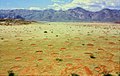
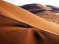 Namib Desert
 -

-
-
 Neckartaldamm
 -


.jpg)


.jpg)
.jpg)
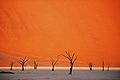
Sossusvlei edit
Main gallery: Sossusvlei.
-
 Oceanic fog near Sossusvlei
 -
 Road to Sossusvlei
 -
 Sossusvlei Dune
 -

-


Animal edit

.jpg)

Etosha National Park edit
| location in Namibia (#5)
|
Main gallery: Etosha National Park.
-
 Etosha pan
 -
-
-
-
 Fort Namutoni


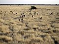
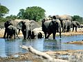
Animal edit
-

-

-
-

-

-
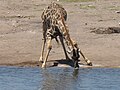 trinkende Giraffe im Etosha Nationalpark
 -
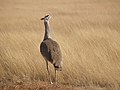
 Dreibandregenpfeifer im Etosha Nationalpark


.jpg)

.jpg)


Sperrgebiet edit
| location in Namibia (#19)
|
Main category: Sperrgebiet


.jpg)
Lüderitz edit
Main gallery: Lüderitz.
-
 Diaz Point
 -
 Große Bucht
 -
 Halifax Island
 -
 Mercury Island


.jpg)
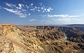
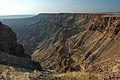
Fish River Canyon edit
| location in Namibia (#1)
|
Main gallery: Fish River Canyon.
-

-
-
-
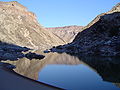 river bed of the Fish River


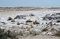
Skeleton Coast National Park edit
| location in Namibia (#3)
|
Main category: Skeleton Coast


World Heritage Site edit
Main category: World Heritage Sites in Namibia
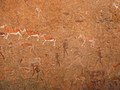
Twyfelfontein edit
 location in Namibia
|
Main gallery: Twyfelfontein.
-
 Lion Petroglyph
 -
 Rock Painting/ Felsmalerei
 -
 San rock art/ San-Felskunst
 -
 Weiße Dame
 -
 Dancing Kudu


City, town and village edit
Main categories: cities in Namibia and villages in Namibia
-
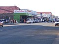
Windhoek
(Capital city) -
-
-

-
 Namibia - Otjikandero Himba Orphan Village - Photo taken in october 2015
 -
 Koës
Koës -
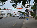
 Henties bay


.jpg)

Region of Namibia edit
Main category: regions of Namibia
Zambezi Region edit
Main gallery: Caprivi.
-
 map of Caprivi
 -
Katima Mulilo
(Capital city) -
 Driving on the Trans-Caprivi Corridor
 -
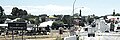
 a Village in the caprivi flood plain/ein Dorf im Überschmemmungsgebiet des Zambesi
 -


Erongo Region edit
Main gallery: Erongo.
-
 map of Erongo
 -

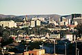
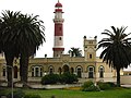
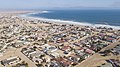
Swakopmund
(Capital city) -
 Dune bashing near Swakopmund
 -

-
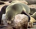
 Cape Cross Seal Colony/ Kreuzkap-Seebärenkolonie
 -

.jpg)
.jpg)


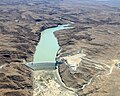
Hardap Region edit
Main gallery: Hardap.
-
 map of Hardap
 -
Mariental
(Capital city) -
 Hardap dam
 -
 Gamsberg
 -


Karas Region edit
Main gallery: Karas.
-
 map of Karas
 -

Keetmanshoop
(Capital city) -

-

-

-


Kavango East Region edit
Main gallery: Kavango.
-
 map of Kavango
 -

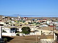
Rundu
(Capital city) -
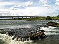
 Popa Falls
 -
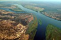
 Okavango river at Utokota
 -
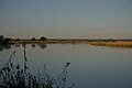 Okavango river at Rundu


Khomas Region edit
Main gallery: Khomas.
-
 map of Khomas
 -

Windhoek
(Capital city) -
 HESS telescopes/ HESS-Teleskope


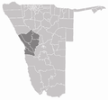
Kunene Region edit
Main gallery: Kunene.
-
 map of Kunene
 -

Opuwo
(Capital city) -
 Kunene river
 -
 Ruacana Falls
 -
 Himba village
 -
 Grootberg
 -
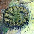
 Fairy circles/ Feenkreise und Hartmannberge

.jpg)


Ohangwena Region edit
Main gallery: Ohangwena.
-
 map of Ohangwena
 -
Eenhana
(Capital city)


Omaheke Region edit
Main gallery: Omaheke.
-
 map of Omaheke
 -

Gobabis
(Capital city) -


Omusati Region edit
Main gallery: Omusati.
-
 map of Omusati
 -

Outapi
(Capital city)


Oshana Region edit
Main gallery: Oshana.
-
 map of Oshana
 -
Oshakati
(Capital city) -
 Der 1976 errichtete Sendemast (275 Meter hoch) im Zentrum von Oshakati
 -
 Dr. Frans Aupa Indongo Open Market in Oshakati, am 11.3.2016 eroeffnet
 -
 Der 48 Meter hohe Aussichtsturm Oshungo ya Shakati am neuen Markt von Oshakati
 -
 Efundia, Oshana


Oshikoto Region edit
Main gallery: Oshikoto.
-
 map of Oshikoto
 -

Omuthiya
(Capital city) -


Otjozondjupa Region edit
Main gallery: Otjozondjupa.
-
 map of Otjozondjupa
 -
Otjiwarongo
(Capital city) -

-
 Cheetah Conservation Fund in Otjiwarongo


Satellite imagery edit
Main category: Satellite pictures of Namibia
-
 NASA's Long Duration Exposure Facility during a photographic survey above the town of Lüderitz
 -
 Fish River Canyon, Huns-berge from LandSat 7
 -
 Sossusvlei, Namib desert from LandSat 7
 -
 Walvis Bay, Erongo from LandSat 7
 -
 Brandberg, Erongo from LandSat 7


Politics edit
Main category: Politics of Namibia
-

-

-

Sam Nujoma
President of the Republic between 1990 and 2005 -

Hifikepunye Pohamba
President of the Republic between 2005 and 2015 -

Nahas Angula
Prime Minister of Namibia between 2005 and 2012 -

Hage Geingob
President of the Republic between 2015 and present -

Saara Kuugongelwa
Prime Minister of Namibia between 2015 and present


.jpg)
Sport edit
Main category: Sports in Namibia

