Airport (Tyne and Wear) Metro station
English: Airport 55°02′11″N 1°42′39″W / 55.0363°N 1.7109°W is a station on the Green Line of the Tyne and Wear Metro, serving Newcastle Airport.
| Opened | New or converted |
Number of platforms | Track alignment | Tyne & Wear metropolitan borough |
| 17 November 1991 | New | 2 | N-S | Newcastle upon Tyne |
| Layout | ||||
| A terminal island platform in a cutting with the two tracks either side ending in buffer stops at their northern ends, partially covered at the southern end by the B6918 road bridging NW-SE | ||||
| Platform no. and position |
Direction of travel M |
Previous stop |
Route | Next stop |
| Platform 1 East |
Southbound | (none) | Green Line to South Hylton (stop 01 of 31) | Callerton Parkway |
| Northbound | Callerton Parkway | Green Line to Airport (stop 31 of 31) | (none) | |
| Platform 2 West |
Southbound | (none) | Green Line to South Hylton (stop 01 of 31) | Callerton Parkway |
| Northbound | Callerton Parkway | Green Line to Airport (stop 31 of 31) | (none) | |
| Notes | ||||
| * M - these are compass headings, which in this station's case do not correspond to the directions diagrammatically indicated on the official Metro route map archive copy at the Wayback Machine - Northbound is Westbound & Southbound is Eastbound on the Metro map | ||||
| Station buildings | ||||
| A rectangular white station hall, 70' by 40', with black full length windows set in sloped walls that rise up to a notional pyramid point (but in reality, bisected by a N-S restricted access airport road over the roof), connected by a covered walkway heading NE to the airport terminal | ||||
| Access | ||||
| A covered walkway emerging SW from the corner of station building NE of the platforms, then turning to head S and descend to platform level, to an opening at their northern end | ||||
| Protection from the elements | ||||
| Full length standalone platform canopy | ||||
| Interchanges | ||||
| air | ||||
-
 The view north east from platform level to the airport terminal buildings
9 May 2007 -
 The view east to the station sign on the other side of the track in Platform 1, with the airport's old control tower in the distance
6 October 2008 -
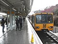 The view south along Platform 2, as Metrocar No. 4048 loads for a journey to South Hylton
8 February 2010 -
 The view north along Platform 2, as Metrocar No. 4042 unloads after finishing a journey to the station
5 January 2009 -
 The view north to the buffers at the end of Platform 1. The vertical glass is part of the covered walkway to the station building (the sloped glass), beyond which the airport terminal is located
5 January 2009 -
 The view south west from Platform 1 across to Platform 2, where Metrocar No. 4059 is loading for a journey to South Hylton
5 January 2009 -
 The view north along Platform 2, as Metrocar No. 4027 unloads after finishing a journey to the station
16 February 2006 -
 The walkway between the terminal (left) and the station building (right)
3 September 2013 -
 The view south along the road the cuts through the top of the station building
3 September 2013


