Category:Église Saint-Hilaire de Nogent-le-Rotrou
| Object location | | View all coordinates using: OpenStreetMap |
|---|
|
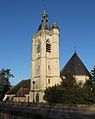
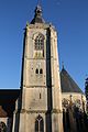
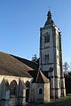
This building is classé au titre des monuments historiques de la France. It is indexed in the base Mérimée, a database of architectural heritage maintained by the French Ministry of Culture, under the reference PA00097175
|
church located in Eure-et-Loir, in France  Façades sud et ouest. | |||||
| Upload media | |||||
| Instance of | |||||
|---|---|---|---|---|---|
| Named after | |||||
| Location | Nogent-le-Rotrou, Eure-et-Loir, Centre-Val de Loire, Metropolitan France, France | ||||
| Street address |
| ||||
| Diocese | |||||
| Owned by | |||||
| Heritage designation |
| ||||
| Religion or worldview | |||||
 | |||||
Subcategories
This category has the following 2 subcategories, out of 2 total.
Media in category "Église Saint-Hilaire de Nogent-le-Rotrou"
The following 12 files are in this category, out of 12 total.
-
 84 Nogent-le-Rotrou église St-Hilaire.jpg 1,024 × 768; 234 KB
-
 85 Nogent-le-Rotrou église Saint-Hilaire.jpg 768 × 1,024; 271 KB
-
 Nogent-le-Rotrou - Town Museum - Louis Moullin - Église Saint-Hilaire vers 1860.JPG 2,856 × 2,352; 2.12 MB
-
 Nogent-le-Rotrou - Église Saint-Hilaire - 1.jpg 3,454 × 4,411; 2.64 MB
-
 Nogent-le-Rotrou - Église Saint-Hilaire - 2.jpg 3,256 × 4,092; 2.04 MB
-
 Nogent-le-Rotrou - Église Saint-Hilaire - 3.jpg 3,456 × 5,184; 2.91 MB
-
 Nogent-le-Rotrou - Église Saint-Hilaire - 4.jpg 3,456 × 5,184; 2.94 MB
-
 Nogent-le-Rotrou - Église Saint-Hilaire - 5.jpg 5,184 × 3,456; 3.24 MB
-
 Nogent-le-Rotrou - Église Saint-Hilaire - 6.jpg 3,456 × 5,184; 2.69 MB
-
 Nogent-le-Rotrou - Église Saint-Hilaire - 7.jpg 5,184 × 3,456; 4.01 MB
-
 Nogent-le-Rotrou - Église Saint-Hilaire - 8.jpg 3,696 × 3,352; 1.58 MB
-
 Nogent-le-Rotrou - Église Saint-Hilaire - 9.JPG 3,168 × 4,499; 1.77 MB


