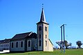
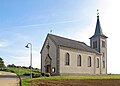
Category:Église Saint-Hubert (Breidweiler)
| Object location | | View all coordinates using: OpenStreetMap |
|---|
 | |||||
| Upload media | |||||
| Instance of | |||||
|---|---|---|---|---|---|
| Location |
| ||||
 | |||||
Media in category "Église Saint-Hubert (Breidweiler)"
The following 5 files are in this category, out of 5 total.
-
 Consdorf, Breidweiler (104).jpg 6,000 × 4,000; 4 MB
-
 Kirche Breidweiler 01.jpg 1,980 × 1,412; 1.76 MB
-
 Kirche Breidweiler 02.jpg 1,982 × 1,415; 1.61 MB
-
 Kirche Breidweiler 03.jpg 1,441 × 1,940; 1.61 MB
-
 Präiteler 1.JPG 4,000 × 3,000; 4.41 MB
.jpg)


