Category:Église Saint-Hubert (Itzig)
| Object location | | View all coordinates using: OpenStreetMap |
|---|
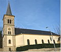
church building in Hesperange, Luxembourg  | |||||
| Upload media | |||||
| Instance of | |||||
|---|---|---|---|---|---|
| Location | Hesperange, Canton of Luxembourg, Luxembourg | ||||
 | |||||
Subcategories
This category has only the following subcategory.
Media in category "Église Saint-Hubert (Itzig)"
The following 15 files are in this category, out of 15 total.
-
 Eglise Saint Hubertus Itzig 2013 01.jpg 3,089 × 2,340; 3.51 MB
-
 KieIze1.JPG 2,627 × 2,237; 395 KB
-
 Kirche Itzig 03.jpg 1,750 × 1,518; 1.49 MB
-
 Église Saint Hubert Itzig-001.jpg 4,272 × 2,812; 5.65 MB
-
 Église Saint Hubert Itzig-002.jpg 3,428 × 2,588; 4.18 MB
-
 Église Saint Hubert Itzig-003.jpg 3,368 × 2,388; 3.57 MB
-
 Église Saint Hubert Itzig-004.jpg 2,848 × 4,288; 7.63 MB
-
 Église Saint Hubert Itzig-005.jpg 2,600 × 3,915; 5.07 MB
-
 Église Saint Hubert Itzig-006.jpg 2,019 × 3,789; 3.82 MB
-
 Église Saint Hubert Itzig-007.jpg 3,836 × 2,548; 4.94 MB
-
 Église Saint Hubert Itzig-008.jpg 2,579 × 3,883; 5.14 MB
-
 Église Saint Hubert Itzig-009.jpg 2,162 × 3,905; 4.23 MB
-
 Église Saint Hubert Itzig-011.jpg 2,221 × 3,344; 4.02 MB
-
 Église Saint Hubert Itzig-012.jpg 2,683 × 4,039; 6.4 MB
-
 Église Saint Hubert Itzig.jpg 2,344 × 2,848; 2.97 MB


