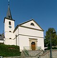
Category:Église Saint-Thomas (Stadtbredimus)
| Object location | | View all coordinates using: OpenStreetMap |
|---|
 | |||||
| Upload media | |||||
| Instance of | |||||
|---|---|---|---|---|---|
| Location |
| ||||
 | |||||
Media in category "Église Saint-Thomas (Stadtbredimus)"
The following 4 files are in this category, out of 4 total.
-
 Kirche Stadtbredimus 01.jpg 1,384 × 2,025; 1.7 MB
-
 Kirche Stadtbredimus 02.jpg 1,450 × 1,930; 1.64 MB
-
 Stadtbredimus Luxembourg church 01.jpg 2,418 × 2,445; 765 KB
-
 Église Saint-Thomas (Stadtbredimus) 2008.jpg 1,181 × 1,797; 445 KB


_2008.jpg)