Category:1570s maps of Lithuania
Countries of Europe: Albania · Armenia‡ · Austria · Azerbaijan‡ · Belgium · Bosnia and Herzegovina · Croatia · Cyprus‡ · France‡ · Georgia‡ · Germany · Greece · Hungary · Italy · Latvia · Lithuania · Netherlands‡ · Poland · Portugal‡ · Romania · Russia‡ · Slovakia · Slovenia · Spain‡ · Turkey‡ · Ukraine
Limited recognition: Abkhazia‡
‡: partly located in Europe
Limited recognition: Abkhazia‡
‡: partly located in Europe
Subcategories
This category has the following 2 subcategories, out of 2 total.
*
1
Media in category "1570s maps of Lithuania"
The following 9 files are in this category, out of 9 total.
-
 Mapa Polski i Litwy 1570.jpg 12,604 × 9,246; 127.67 MB
-
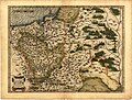 Ortelius Lithuania.jpg 2,220 × 1,682; 822 KB
-
 Atlas Ortelius KB PPN369376781-082av-082br.jpg 3,000 × 2,194; 4.7 MB
-

-
 Poland in 1570s-1580s (reign of Batory).jpg 1,200 × 1,027; 156 KB
-
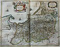
 PRVSSIA1576Casparo Henneberg.png 2,973 × 2,289; 4.5 MB
-
 LIVONIAE NOVA DESCRIPTIO 1573-1578.jpg 1,998 × 1,791; 1.57 MB
-
 Vepriai old map.jpg 360 × 252; 88 KB
-
 "Prussia accurate descripta - a Gasparo Henneberg Erlichensi." (22064855660).jpg 3,865 × 3,005; 2.46 MB


.jpg)


.jpg)