Category:1690s maps of Quebec
Provinces and territories of Canada: Quebec ·
Media in category "1690s maps of Quebec"
The following 3 files are in this category, out of 3 total.
-
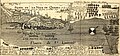 Québec 1691 Voyages 1728.jpg 2,012 × 940; 867 KB
-
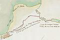 Canal Saint-Gabriel.jpg 1,024 × 682; 440 KB
-
 Fort Richelieu 1695.jpg 1,000 × 1,533; 300 KB


