Category:1720s maps of the world
| 18th-century maps of the world: ← 1700s 1710s 1720s 1730s 1740s 1750s 1760s 1770s 1780s 1790s → |
English: This category is supposed to hold world maps created in the 1720s.
Subcategories
This category has only the following subcategory.
Media in category "1720s maps of the world"
The following 19 files are in this category, out of 19 total.
-
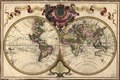
 1720 map of the world - Mappemonde a l'usage du Roy.jpg 17,195 × 11,715; 26.96 MB
-
 Mappemonde a l'usage du Roy Par Guillaume Delisle Premier.jpg 1,024 × 692; 156 KB
-
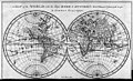
 Orbis Terrarum J D Köhler.jpg 940 × 918; 383 KB
-

-
 Mappemonde - l'usage du Roy par Guillaume Delisle Premier geographe de Sm.png 7,732 × 5,070; 63.26 MB
-
 Mappemonde a l'usage du roy LOC 2005627023.jpg 8,264 × 5,573; 7.93 MB
-
 Mappemonde a l'usage du roy LOC 2005627023.tif 8,264 × 5,573; 131.77 MB
-
 Guillaume Delisle, Mappe monde (FL80386290 2718607).jpg 15,840 × 13,424; 238.24 MB
-

-

-
 A map of the world - Norman B. Leventhal Map Center at the BPL.jpg 1,200 × 712; 317 KB
-
-

-

-
 A New Map of the World 1721.jpg 11,617 × 9,576; 52.93 MB
-

-

-
 Nieuwe Wassende Graaden Paskaart.jpg 6,177 × 3,664; 3.89 MB
-


.jpg)


_Les_Forces_de_l%27Europe,_Asie,_Afrique_et_Amerique_Comme_aussi_les_Cartes_des_C%C3%B4tes_de_France_et_d%27Espagne_(serieti,_RP-P-OB-83.035-14.jpg)
_by_John_Senex._Original_from_The_Beinecke_Rare_Book_%26_Manuscript_Library._Digitally_enhanced_by_rawpixel._(50622864728).jpg)