Category:1759 maps of the Caribbean
Media in category "1759 maps of the Caribbean"
The following 22 files are in this category, out of 22 total.
-

-
-

-

-

-

-
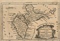
 Carte réduite des isles de la Guadeloupe, Marie Galante, et les Saintes. LOC 75693282.jpg 10,476 × 7,287; 10.59 MB
-
 Carte réduite des isles de la Guadeloupe, Marie Galante, et les Saintes. LOC 75693282.tif 10,476 × 7,287; 218.41 MB
-

-

-

-

-

-

-
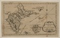
 Guadalupe with the adjacent islands. LOC 2010593356.jpg 3,319 × 2,112; 818 KB
-
 Guadalupe with the adjacent islands. LOC 2010593356.tif 3,319 × 2,112; 20.06 MB
-
 Guadeloupe Banat 1.1.png 783 × 671; 927 KB
-
 Guadeloupe Banat v2.png 768 × 656; 978 KB
-
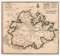
 Insula Antegoa ad fidem prototypi Londinensis LOC 74691680.jpg 3,469 × 3,252; 1.74 MB
-
 Insula Antegoa ad fidem prototypi Londinensis LOC 74691680.tif 3,469 × 3,252; 32.28 MB
-

-


.jpg)


