Category:1780 maps of Georgia (U.S. state)
States of the United States: Alabama · Florida · Georgia · Illinois · Massachusetts · Michigan · Montana · New Jersey · New York · North Dakota · Pennsylvania · Wisconsin
Puerto Rico
Puerto Rico
| 1780 |
Media in category "1780 maps of Georgia (U.S. state)"
The following 8 files are in this category, out of 8 total.
-

-
-
 (Savannah & its fortifications. LOC 74692120.jpg 7,596 × 6,306; 5.15 MB
-
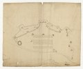 (Savannah & its fortifications. LOC 74692120.tif 7,596 × 6,306; 137.04 MB
-
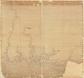
 (Savannah River & Ogeechee River). LOC 73691564.jpg 4,336 × 3,702; 2.37 MB
-
 (Savannah River & Ogeechee River). LOC 73691564.tif 4,336 × 3,702; 45.93 MB
-
 (Savannah. LOC 73691565.jpg 5,486 × 4,576; 3.41 MB
-
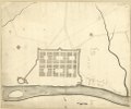 (Savannah. LOC 73691565.tif 5,486 × 4,576; 71.82 MB
_LOC_73691562.jpg)

._LOC_73691564.jpg)
