Category:1840–41 Royal Engineers maps of Palestine and Syria
| Upload media | |||||
| Instance of | |||||
|---|---|---|---|---|---|
| Collection | |||||
| |||||
Media in category "1840–41 Royal Engineers maps of Palestine and Syria"
The following 8 files are in this category, out of 8 total.
-

-

-
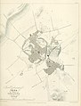 1840–41 Royal Engineers map of Gaza.jpg 2,360 × 3,098; 694 KB
-
 1840–42 Royal Engineers map of Jaffa.jpg 2,059 × 1,955; 961 KB
-
 1840–43 Royal Engineers map of Acre (close up).jpg 2,344 × 3,098; 440 KB
-
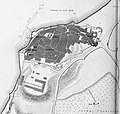
 1840–44 Royal Engineers map of Acre and surrounding region.jpg 2,270 × 2,475; 658 KB
-
 1841 Aldrich and Symonds map of Jerusalem.jpg 7,488 × 6,922; 8.99 MB
-


.jpg)


.jpg)