Category:1860s maps of Guatemala
Countries of the Americas: Argentina · The Bahamas · Belize · Bolivia · Brazil · Canada · Chile · Colombia · Costa Rica · Cuba · Ecuador · Guatemala · Jamaica · Mexico · Panama · Paraguay · Peru · Saint Vincent and the Grenadines · United States of America · Uruguay · Venezuela
Other areas: Puerto Rico
Other areas: Puerto Rico
Media in category "1860s maps of Guatemala"
This category contains only the following file.
-
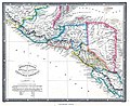 Guatemala or United States of Central America.jpg 3,927 × 3,204; 11.06 MB
