Category:1860s maps of Maryland
States of the United States: Alabama · Alaska · Arizona · Arkansas · California · Colorado · Connecticut · Delaware · Florida · Georgia · Idaho · Illinois · Indiana · Iowa · Kansas · Kentucky · Louisiana · Maine · Maryland · Massachusetts · Michigan · Minnesota · Mississippi · Missouri · Montana · Nebraska · Nevada · New Hampshire · New Jersey · New Mexico · New York · North Carolina · North Dakota · Ohio · Oklahoma · Oregon · Pennsylvania · Rhode Island · South Carolina · South Dakota · Tennessee · Texas · Utah · Vermont · Virginia · Washington · West Virginia · Wisconsin · Wyoming – Washington, D.C.
Puerto Rico
Puerto Rico
Subcategories
This category has the following 6 subcategories, out of 6 total.
- 1860 maps of Maryland (11 F)
- 1863 maps of Maryland (10 F)
Media in category "1860s maps of Maryland"
The following 16 files are in this category, out of 16 total.
-
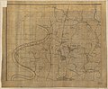
 (No. 2) Map of the battlefield of Antietam LOC 99447387.jpg 9,026 × 10,790; 13.38 MB
-
 (No. 2) Map of the battlefield of Antietam LOC 99447387.tif 9,026 × 10,790; 278.64 MB
-
-
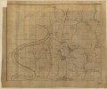 (Northwest, or no. 1 sheet of preliminary map of Antietam (Sharpsburg) battlefield). LOC 2005625020.tif 10,642 × 8,804; 268.06 MB
-

-
 Potomac River, Maryland and Virginia Border 1861.jpg 1,191 × 976; 531 KB
-

-
 Montgomery County MD 1862 Darnestown.png 728 × 710; 822 KB
-

-
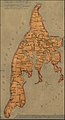
 Martenet and Bond's map of Montgomery County, Maryland LOC 2002620533.tif 10,960 × 9,395; 294.6 MB
-

-

-
 Map of Kent Island -1866.jpg 1,588 × 2,930; 428 KB
-

-

-

_Map_of_the_battlefield_of_Antietam_LOC_99447387.jpg)
_battlefield)._LOC_2005625020.jpg)


.jpg)
