Category:1860s maps of Ontario
Subcategories
This category has the following 7 subcategories, out of 7 total.
- 1862 maps of Ontario (4 F)
- 1864 maps of Ontario (1 F)
- 1866 maps of Ontario (1 F)
- 1869 maps of Ontario (2 F)
T
Media in category "1860s maps of Ontario"
The following 2 files are in this category, out of 2 total.
-
 Hastings County Archives HC02571A (27181266098).jpg 1,454 × 967; 201 KB
-
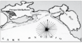 Proposed harbour of refuge, Weller's Bay, 1861.png 429 × 227; 134 KB
.jpg)
