Category:1872 maps of the United States
Countries of the Americas: Canada · United States of America
States of the United States: California · Illinois · Massachusetts · Michigan · New York · Oregon · Pennsylvania · Texas · Utah · Wyoming – Washington, D.C.
Subcategories
This category has the following 12 subcategories, out of 12 total.
C
- 1872 maps of California (1 F)
D
I
- 1872 maps of Illinois (2 F)
M
- 1872 maps of Massachusetts (10 F)
N
- 1872 maps of New York (state) (35 F)
O
- 1872 maps of Oregon (1 F)
P
T
- 1872 maps of Texas (2 F)
U
- 1872 maps of Utah (1 F)
W
- 1872 maps of Wyoming (5 F)
Media in category "1872 maps of the United States"
The following 34 files are in this category, out of 34 total.
-
 1872 Birds Eye View of Columbus Ohio - alternate.png 11,764 × 7,542; 165.17 MB
-
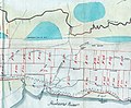
 1872 map of central Robeson County.png 646 × 308; 213 KB
-

-
 AtlanticCountyMap1872byFWBeers.jpg 19,420 × 20,740; 37.85 MB
-

-
 Bird's eye view of the city of Columbia, South Carolina, 1872 - C. Drie. LCCN2008675451.jpg 9,475 × 6,354; 9.82 MB
-
 Bird's eye view of the city of Columbia, South Carolina, 1872 - C. Drie. LCCN2008675451.tif 9,475 × 6,354; 172.27 MB
-
 Charleston South Carolina map 1872.jpg 10,436 × 6,880; 20.38 MB
-

-
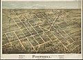 Fostoria, Seneca County, O. (2674662024).jpg 2,000 × 1,458; 3.16 MB
-

-
 HudsonCountyMap1872.jpg 640 × 530; 128 KB
-

-
 Irish American2.png 1,647 × 2,010; 5.56 MB
-
 Map of the Lakes and Drives around Oconomowoc.jpg 2,016 × 1,504; 937 KB
-

-
-

-
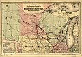
 Map showing the Indiana & Illinois Central Railway and its connections. LOC 98688683.jpg 8,604 × 8,247; 17.34 MB
-
 Map showing the Indiana & Illinois Central Railway and its connections. LOC 98688683.tif 8,604 × 8,247; 203.01 MB
-

-
-

-
-
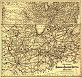
 Map showing the line of the Savannah & Memphis Railroad and its connections. LOC 98688798.jpg 9,918 × 6,792; 14.12 MB
-
 Map showing the line of the Savannah & Memphis Railroad and its connections. LOC 98688798.tif 9,918 × 6,792; 192.73 MB
-

-
-

-

-

-
 Sketch of a hypsometric chart of the United States LOC 2018590112.jpg 5,487 × 4,123; 4.07 MB
-
 Sketch of a hypsometric chart of the United States LOC 2018590112.tif 5,487 × 4,123; 64.72 MB
-
 Wealth, per capita, in the United States, from 9th US Census (1872).jpg 1,635 × 2,032; 580 KB


.jpg)
.jpg)


.jpg)


.jpg)

.jpg)