Category:1880 U.S. presidential election maps, county subdivisions
Media in category "1880 U.S. presidential election maps, county subdivisions"
The following 15 files are in this category, out of 15 total.
-
 CartogramDemocraticPresidentialCounty1880Colorbrewer.png 2,800 × 1,700; 287 KB
-
 CartogramOtherPresidentialCounty1880Colorbrewer.png 2,800 × 1,700; 290 KB
-
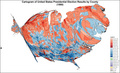 CartogramPresidentialCounty1880Colorbrewer.png 2,800 × 1,700; 320 KB
-
 CartogramRepublicanPresidentialCounty1880Colorbrewer.png 2,800 × 1,700; 286 KB
-
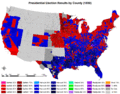
 1880 United States presidential election results map by county.svg 555 × 352; 1.16 MB
-
 DemocraticPresidentialCounty1880.png 2,800 × 2,200; 195 KB
-
 DemocraticPresidentialCounty1880Colorbrewer.png 2,800 × 1,700; 231 KB
-
 OtherPresidentialCounty1880.gif 2,800 × 2,200; 210 KB
-
 OtherPresidentialCounty1880Colorbrewer.gif 2,800 × 1,700; 174 KB
-
 PresidentialCounty1880.gif 2,800 × 2,200; 276 KB
-
 PresidentialCounty1880Colorbrewer.gif 2,800 × 1,700; 212 KB
-
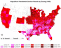 RepublicanPresidentialCounty1880.gif 2,800 × 2,200; 239 KB
-
 RepublicanPresidentialCounty1880Colorbrewer.gif 2,800 × 1,700; 177 KB
-
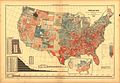 Scribners-1880-Popular-Vote1.jpg 2,132 × 1,475; 1.22 MB
-
 Votes for Republican President James A Garfield 1880.gif 549 × 493; 110 KB


