Category:1880s maps of Slovakia
Countries of Europe: Armenia‡ · Azerbaijan‡ · Belgium · Bosnia and Herzegovina · Bulgaria · Croatia · Cyprus‡ · Czech Republic · Denmark · Estonia · Finland · France‡ · Georgia‡ · Germany · Greece · Hungary · Iceland · Republic of Ireland · Italy · Latvia · Lithuania · Montenegro · Netherlands‡ · Norway · Poland · Portugal‡ · Romania · Russia‡ · Serbia · Slovakia · Slovenia · Spain‡ · Sweden · Switzerland · Turkey‡ · Ukraine · United Kingdom
Limited recognition: Abkhazia‡
‡: partly located in Europe
Limited recognition: Abkhazia‡
‡: partly located in Europe
Media in category "1880s maps of Slovakia"
The following 7 files are in this category, out of 7 total.
-
 Detva BV043866905.jpg 11,830 × 9,520; 23 MB
-
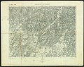
 Mošovce (Turčianske Teplice) BV043866918.jpg 12,848 × 9,168; 25.22 MB
-
 Aufnahmeblatt 4758-1 UNG Theben, Marchmündung.jpg 9,310 × 7,134; 50.47 MB
-
 Handlová BV043867053.jpg 14,406 × 11,102; 31.49 MB
-
 Nová Baňa BV035894221.jpg 9,906 × 7,804; 11.95 MB
-
 Slovenské Pravno BV043867073.jpg 12,180 × 9,920; 25.16 MB
-
 Svodin BV035904793.jpg 8,238 × 6,989; 9.58 MB

_BV043866918.jpg)


