Category:1885 maps of Illinois
States of the United States: California · Connecticut · Delaware · Florida · Georgia · Hawaii · Illinois · Indiana · Iowa · Kansas · Kentucky · Louisiana · Maine · Maryland · Massachusetts · Michigan · Minnesota · Mississippi · Missouri · Nevada · New Hampshire · New Jersey · New York · North Carolina · Ohio · Oregon · Pennsylvania · Rhode Island · Tennessee · Texas · Vermont · Virginia · Washington · Wisconsin – Washington, D.C.
| ← 1880 1881 1883 1884 1885 1886 1887 1888 1889 → |
Subcategories
This category has the following 17 subcategories, out of 17 total.
S
Media in category "1885 maps of Illinois"
The following 23 files are in this category, out of 23 total.
-
 1885 Humboldt Park Map personal photograph, by myself, of my map.jpg 2,048 × 1,536; 2.81 MB
-
 1885 Mitchell map of Chicago.jpg 5,707 × 6,459; 5.33 MB
-
 CairoIllPerspectiveMap1885.jpg 1,027 × 591; 150 KB
-

-
 Sanborn Fire Insurance Map from Braceville, Grundy County, Illinois. LOC sanborn01742 001.tif 6,450 × 7,650; 141.17 MB
-
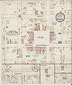
 Sanborn Fire Insurance Map from Cambridge, Henry County, Illinois. LOC sanborn01761 001.jpg 6,450 × 7,650; 4.01 MB
-
 Sanborn Fire Insurance Map from Cambridge, Henry County, Illinois. LOC sanborn01761 001.tif 6,450 × 7,650; 141.17 MB
-

-
 Sanborn Fire Insurance Map from Carthage, Hancock County, Illinois. LOC sanborn01772 001.tif 6,450 × 7,650; 141.17 MB
-
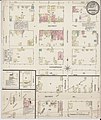
 Sanborn Fire Insurance Map from Clayton, Adams County, Illinois. LOC sanborn01796 001.jpg 6,450 × 7,650; 3.57 MB
-
 Sanborn Fire Insurance Map from Clayton, Adams County, Illinois. LOC sanborn01796 001.tif 6,450 × 7,650; 141.17 MB
-
 Sanborn Fire Insurance Map from Coal City, Grundy County, Illinois. LOC sanborn01798 001.jpg 6,450 × 7,650; 3.78 MB
-
 Sanborn Fire Insurance Map from Coal City, Grundy County, Illinois. LOC sanborn01798 001.tif 6,450 × 7,650; 141.17 MB
-
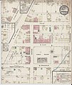
 Sanborn Fire Insurance Map from Elmwood, Peoria County, Illinois. LOC sanborn01851 001.jpg 6,450 × 7,650; 4.08 MB
-
 Sanborn Fire Insurance Map from Elmwood, Peoria County, Illinois. LOC sanborn01851 001.tif 6,450 × 7,650; 141.17 MB
-
-
 Sanborn Fire Insurance Map from Greenfield, Greene County, Illinois. LOC sanborn01903 001.tif 6,450 × 7,650; 141.17 MB
-
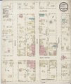
 Sanborn Fire Insurance Map from Griggsville, Pike County, Illinois. LOC sanborn01907 001.jpg 6,450 × 7,650; 3.89 MB
-
 Sanborn Fire Insurance Map from Griggsville, Pike County, Illinois. LOC sanborn01907 001.tif 6,450 × 7,650; 141.17 MB
-

-
 Sanborn Fire Insurance Map from Mount Sterling, Brown County, Illinois. LOC sanborn02033 001.tif 6,450 × 7,650; 141.17 MB
-
 Sanborn Fire Insurance Map from Roodhouse, Greene County, Illinois. LOC sanborn02129 001.jpg 6,450 × 7,650; 4.29 MB
-
 Sanborn Fire Insurance Map from Roodhouse, Greene County, Illinois. LOC sanborn02129 001.tif 6,450 × 7,650; 141.17 MB


