Category:1920 maps of the United Kingdom
Countries of Europe: Belarus · Croatia · Estonia · Finland · France‡ · Germany · Greece · Latvia · Lithuania · Norway · Poland · Russia‡ · Serbia · Slovenia · Spain‡ · Switzerland · Turkey‡ · Ukraine · United Kingdom
‡: partly located in Europe
‡: partly located in Europe
Media in category "1920 maps of the United Kingdom"
The following 4 files are in this category, out of 4 total.
-
 1920s Bartholomew Fire Brigade Map of London, England - Geographicus - London-bartholomew.jpg 9,000 × 6,715; 20.89 MB
-
 Irish.Sea.at.Man.cross.section.jpg 1,800 × 420; 48 KB
-
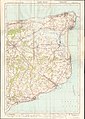 Ordnance Survey One-Inch Sheet 117 East Kent, Published 1920.jpg 8,603 × 12,090; 35.28 MB
-
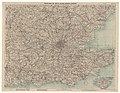 Road map of fifty miles round London - btv1b53192684b.jpg 9,509 × 7,365; 17.93 MB


