Category:1940 maps of Florida
States of the United States: Alaska · Arizona · California · Colorado · Florida · Georgia · Illinois · Iowa · Louisiana · Massachusetts · Michigan · Missouri · Montana · New Hampshire · New Mexico · New York · North Carolina · North Dakota · Ohio · Oregon · Pennsylvania · South Carolina · Tennessee · Texas · Washington
| 1940 1945 |
Subcategories
This category has only the following subcategory.
Media in category "1940 maps of Florida"
The following 3 files are in this category, out of 3 total.
-
 1940 Florida gubernatorial election results map by county.svg 744 × 727; 423 KB
-
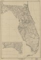
 State of Florida; base map LOC 99466712.jpg 6,575 × 9,448; 7.17 MB
-
 State of Florida; base map LOC 99466712.tif 6,575 × 9,448; 177.73 MB

