Category:1944 maps of Europe
Temperate regions: North America · South America · Africa · Europe · Asia · Oceania – Polar regions: – Other regions:
English: 1944 maps of Europe
Español: Mapas de Europa en 1944
Suomi: Euroopan kartat vuodelta 1944
Română: Hărți ale Europei din 1944
Subcategories
This category has the following 16 subcategories, out of 16 total.
-
A
- 1944 maps of Austria (5 F)
F
- 1944 maps of France (210 F)
- 1945 maps of France (4 F)
G
- 1944 maps of Greece (2 F)
I
- 1944 maps of Italy (20 F)
L
- 1944 maps of Lithuania (10 F)
- 1944 maps of Luxembourg (1 F)
N
- 1944 maps of Norway (13 F)
P
- 1944 maps of Poland (2 F)
S
- 1944 maps of Spain (2 F)
- 1944 maps of Switzerland (1 F)
U
Media in category "1944 maps of Europe"
The following 17 files are in this category, out of 17 total.
-
 30 Corps Dispositions 21-22 December 1944 - NARA - 100384374 (page 1).jpg 7,360 × 5,896; 6.91 MB
-
 30 Corps Dispositions 21-22 December 1944 - NARA - 100384374 (page 2).jpg 7,360 × 5,891; 7.12 MB
-
 After Action Report - Vodňany - NARA - 100384947.jpg 10,800 × 7,843; 9.91 MB
-
 After Action Report - Znojmo - NARA - 100384945.jpg 10,800 × 7,837; 9.85 MB
-
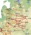
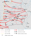 Centre du Front de l'Est du 22 juin au 29 aout 1944-es.svg 2,082 × 2,406; 215 KB
-
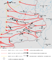 Centre du Front de l'Est du 22 juin au 29 aout 1944.svg 2,082 × 2,406; 221 KB
-
 Europe as viewed from the USSR, 1944.jpg 5,327 × 4,011; 6.17 MB
-
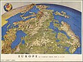
 Europe from the southwest, 1944.jpg 5,496 × 3,487; 2.66 MB
-
 Hungary in 1942.png 1,200 × 647; 30 KB
-
 Leningrad-Novgorod.jpg 800 × 1,043; 417 KB
-
 Newsmap - June 12, 1944.jpg 2,580 × 1,930; 1.6 MB
-
 OEF-map-4.jpg 1,000 × 654; 100 KB
-
 OEF-map-5.jpg 989 × 568; 81 KB
-
 OEF-map-6.jpg 1,148 × 683; 118 KB
-
 OEF-map-7.jpg 1,000 × 591; 73 KB
-
 Operation bagration overview 22 june 1944 to 29 august 1944.png 894 × 1,016; 983 KB
-
 Корсунь-Шевченковская операция.jpg 896 × 970; 212 KB
.jpg)
.jpg)


