Category:1972 United States Senate election maps
Media in category "1972 United States Senate election maps"
The following 42 files are in this category, out of 42 total.
-
 1972 MA Senate.png 2,400 × 1,492; 111 KB
-

-
 1972 United States Senate election in Arkansas results map by county.svg 744 × 655; 384 KB
-

-

-
 1972 United States Senate election in Georgia results map by county.svg 744 × 744; 690 KB
-
-

-
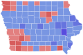 1972 United States Senate election in Iowa results map by county.svg 810 × 532; 31 KB
-

-

-

-

-
 1972 United States Senate Election in Massachusetts by Town.svg 810 × 502; 182 KB
-
 1972 United States Senate election in Massachusetts results map by municipality.svg 2,100 × 1,300; 1.55 MB
-

-

-

-

-

-

-

-

-

-
-

-

-
 1972 United States Senate election in Texas results map by county.svg 810 × 769; 104 KB
-

-

-

-
 1972 United States Senate elections results map.svg 959 × 593; 83 KB
-

-
 1972 virginia senate election map.png 833 × 364; 34 KB
-
 Massachusetts United States Senate Democratic primary results by municipality, 1972.svg 2,100 × 1,300; 1.58 MB
-
 Oklahoma 1972 senate election.svg 898 × 433; 84 KB
-
 Oklahoma Senate Election Results by County, 1972.svg 320 × 168; 47 KB
-
-
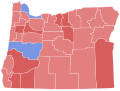
 Oregon Senate Election Results by County, 1972.svg 248 × 188; 17 KB
-
 South Dakota Senate Election Results by County, 1972.svg 243 × 152; 26 KB
-
 US Senate 1972 Delaware by State House District.svg 485 × 760; 202 KB
-
 Us senate result 1972.PNG 506 × 313; 10 KB


