Category:1980 maps of California
States of the United States: Alabama · Arkansas · California · Connecticut · Delaware · Florida · Georgia · Kentucky · Maine · Maryland · Massachusetts · Mississippi · New Jersey · New York · North Carolina · Ohio · Pennsylvania · South Carolina · Tennessee · Texas · Utah · Vermont · Virginia · West Virginia
| 1980 1981 1982 1983 1984 1987 1989 |
Media in category "1980 maps of California"
The following 7 files are in this category, out of 7 total.
-
 All About Muni Metro (1980).jpg 5,232 × 2,592; 2.07 MB
-
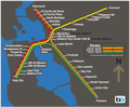
 BART map effective July 7, 1980.jpg 716 × 598; 73 KB
-
 BART map effective July 7, 1980.png 8,300 × 6,900; 566 KB
-
 BART proposed extensions map, 1980.jpg 575 × 620; 60 KB
-
 BART system map, 1980.jpg 1,381 × 1,182; 192 KB
-
 SFSupervisorDistricts1977-1980.png 948 × 784; 34 KB
-
 SFSupervisorDistricts1977-1980.svg 948 × 784; 68 KB
.jpg)


