Category:19th century maps of Finistère
Subcategories
This category has the following 2 subcategories, out of 2 total.
1
Media in category "19th century maps of Finistère"
The following 18 files are in this category, out of 18 total.
-
 050A Saint-Guénolé Cadastre 1833.JPG 1,465 × 724; 352 KB
-

-

-
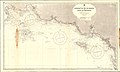
 Admiralty Chart No 2351 Anse de Benodet to Chaussee de Sein, Published 1895.jpg 17,669 × 11,328; 47.36 MB
-
-
 Admiralty Chart No 2744 The Channels and Rade de Morlaix, Published 1861.jpg 11,081 × 16,241; 59.57 MB
-
 Admiralty Chart No 2745 France, north coast, Ile de Bas and adjacent coast, Published 1860.jpg 11,528 × 7,705; 45.97 MB
-
 ARCHIVES CM 965 Pub 1842 Ed 1887 Corr 1897.jpg 8,355 × 12,278; 19.06 MB
-
 Construction du phare d'Armen système de débarquement (1875).jpg 4,289 × 5,820; 2.75 MB
-
 Dépt. du Finistère (région du nord) - Fonds Ancely - B315556101 A LEVASSEUR 032.jpg 3,075 × 2,034; 2.1 MB
-
 LaNature1873-389-PharesFinistère.png 473 × 569; 64 KB
-
 Landudec cadastre ancien.jpg 369 × 279; 82 KB
-
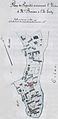 Plan cadastral 1880 Île-Tudy.jpg 404 × 828; 196 KB
-
 Plan de l'Aberildut 1816.jpg 902 × 516; 320 KB
-
 Plan de la cathédrale et de l'évêché de Quimper (1853) - Archives nationales (France).jpg 3,123 × 3,807; 1.21 MB
-
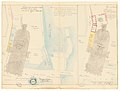 Plan des abords de la cathédrale de Quimper (1850) - Archives nationales (France).jpg 3,948 × 2,985; 1.16 MB
-
 Plouescat Plan de 1828.jpg 1,480 × 664; 647 KB
-
 Tevennec sectors 1895.png 710 × 808; 435 KB


.jpg)
_-_Fonds_Ancely_-_B315556101_A_LEVASSEUR_032.jpg)


_-_Archives_nationales_(France).jpg)
_-_Archives_nationales_(France).jpg)

