Category:2000 United States Census TIGER maps of populated places
English: Maps of cities and other local populated places, such as Census Designated Places, towns, and villages, from the United States Census map generator using TIGER data for the 2000 United States Census. These maps are generally updated every 10 years.
Subcategories
This category has the following 3 subcategories, out of 3 total.
C
Media in category "2000 United States Census TIGER maps of populated places"
The following 22 files are in this category, out of 22 total.
-
 2006 EQ chemical plant fire Apex North Carolina location.png 437 × 328; 39 KB
-
 Az-flagstaff.png 575 × 425; 33 KB
-
 Bolinas CDP, California.png 575 × 425; 23 KB
-
 Garden Grove, California Map.gif 575 × 425; 29 KB
-
 Henderson-nv-map.gif 575 × 425; 28 KB
-
 Key West city.png 575 × 425; 39 KB
-
 LosAngelesCAMap.gif 575 × 425; 64 KB
-
 Marathon.gif 575 × 425; 14 KB
-
 Milpitas layout.gif 500 × 375; 28 KB
-
 NDBalance.gif 722 × 542; 327 KB
-
 North Key Largo.gif 575 × 425; 20 KB
-
 NorthBayShoreCDP.gif 575 × 425; 81 KB
-
 Pine Bush New York.gif 422 × 359; 10 KB
-
 Pinecrest.gif 575 × 425; 75 KB
-
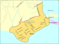
 Provincetown-map.gif 575 × 425; 23 KB
-
 Schiller Park IL 2009 reference map.gif 575 × 425; 42 KB
-
 Searchlight-map.gif 575 × 425; 15 KB
-
 Spackenkill.gif 575 × 425; 67 KB
-
 Tulsa, OK - TIGER map.gif 422 × 359; 20 KB
-
 Walden map.gif 422 × 359; 11 KB
-
 Wilmette IL 2009 reference map.gif 575 × 425; 47 KB
-
 Winnetka IL 2009 reference map.gif 575 × 425; 42 KB


