Category:2000 United States gubernatorial election maps
Media in category "2000 United States gubernatorial election maps"
The following 18 files are in this category, out of 18 total.
-
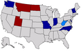
 2000 United States gubernatorial elections results map.svg 959 × 593; 63 KB
-
 2000 Indiana gubernatorial election results map by county.svg 810 × 810; 35 KB
-
 2000 Missouri gubernatorial election results map by county.svg 810 × 717; 49 KB
-
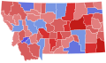 2000 Montana gubernatorial election results map by county.svg 810 × 473; 48 KB
-
 2000 New Hampshire gubernatorial election results map by county.svg 810 × 810; 14 KB
-

-
 2000 North Carolina gubernatorial election results map by county.svg 810 × 316; 80 KB
-
 2000 North Dakota gubernatorial election results map by county.svg 810 × 488; 28 KB
-
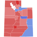 2000 Utah gubernatorial election results map by county.svg 810 × 810; 29 KB
-
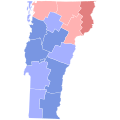 2000 Vermont gubernatorial election results map by county.svg 810 × 810; 17 KB
-
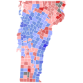 2000 Vermont gubernatorial election results map by municipality.svg 810 × 810; 105 KB
-
 2000 Washington gubernatorial election results map by county.svg 810 × 535; 61 KB
-
 2000 West Virginia gubernatorial election results map by county.svg 810 × 719; 38 KB
-
 Delaware Governor Election Results by County, 2000.svg 810 × 810; 6 KB
-
 2000 North Carolina gubernatorial Republican primary county map.svg 690 × 300; 72 KB
-
 NC Governor County Map 2000.PNG 512 × 384; 31 KB
-
 Us gov 00.png 522 × 324; 14 KB
-
 WestVirginiaGubernatorialElection 2000.png 672 × 600; 94 KB


