Category:2 Canning Street, Liverpool
| Object location | | View all coordinates using: OpenStreetMap |
|---|
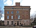
2 Canning Street is an 1830s Grade II* listed house at the north end of Gambier Terrace, from which it derives its listed status.
Media in category "2 Canning Street, Liverpool"
The following 3 files are in this category, out of 3 total.
-
 2 Canning Street, Liverpool 2021.jpg 4,243 × 3,332; 16.05 MB
-
 2 Canning Street.jpg 4,194 × 3,369; 5.91 MB
-
 Gates of Gambier Terrace.jpg 4,373 × 3,353; 7.37 MB


