Category:9 - 21 Rodney Street, Liverpool
| Object location | | View all coordinates using: OpenStreetMap |
|---|
This is a category about listed building number 1209572. |
building in Liverpool, Merseyside, UK | |||||
| Upload media | |||||
| Instance of | |||||
|---|---|---|---|---|---|
| Location | Liverpool, Merseyside, North West England, England | ||||
| Heritage designation |
| ||||
 | |||||
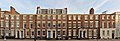
Grade II listed terrace of seven late 18th century houses on Rodney Street, Liverpool. In brick with stone dressings and slate roof.
Subcategories
This category has only the following subcategory.
9
Media in category "9 - 21 Rodney Street, Liverpool"
The following 2 files are in this category, out of 2 total.
-
 21 Rodney Street, Liverpool.jpg 3,024 × 4,857; 8.41 MB
-
 9 - 21 Rodney Street.jpg 9,378 × 3,225; 20.59 MB
