Category:A new and accurate chart of the Bay of Chesapeake (1776)
Media in category "A new and accurate chart of the Bay of Chesapeake (1776)"
The following 17 files are in this category, out of 17 total.
-
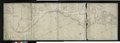
 A New and accurate chart of the bay of Chesapeake - R. Sayer - btv1b53089956z (1 of 4).jpg 9,318 × 6,990; 9.21 MB
-
 A New and accurate chart of the bay of Chesapeake - R. Sayer - btv1b53089956z (2 of 4).jpg 9,421 × 7,018; 9.26 MB
-
 A New and accurate chart of the bay of Chesapeake - R. Sayer - btv1b53089956z (3 of 4).jpg 9,336 × 7,002; 9.25 MB
-
 A New and accurate chart of the bay of Chesapeake - R. Sayer - btv1b53089956z (4 of 4).jpg 9,336 × 7,002; 8.39 MB
-
 A New and accurate chart of the bay of Chesapeake - R. Sayer - btv1b53089957d.jpg 17,334 × 11,748; 28.44 MB
-
 A New and accurate chart of the bay of Chesapeake - R. Sayer - btv1b53089958v (1 of 2).jpg 17,377 × 12,024; 29.68 MB
-
 A New and accurate chart of the bay of Chesapeake - R. Sayer - btv1b53089958v (2 of 2).jpg 1,812 × 2,859; 1.02 MB
-
-

-

-

-

-

-

-

-

-

.jpg)
.jpg)
.jpg)
.jpg)

.jpg)
.jpg)

.jpg)
.jpg)
.jpg)
.jpg)