Category:Aengwirder Tsjerke
| Object location | | View all coordinates using: OpenStreetMap |
|---|
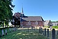
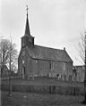
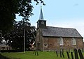
church building in Heerenveen, Netherlands  | |||||
| Upload media | |||||
| Instance of | |||||
|---|---|---|---|---|---|
| Location | Tjalleberd, Friesland, Netherlands | ||||
| Street address |
| ||||
| Located on street |
| ||||
| Heritage designation |
| ||||
| Inception |
| ||||
| Significant event |
| ||||
 | |||||
|
This is a category about rijksmonument number 21199
|
| Address |
|
Media in category "Aengwirder Tsjerke"
The following 12 files are in this category, out of 12 total.
-
 2023 Tsjalbert, Aenjewierster tsjerke (1).jpg 2,218 × 2,221; 1.57 MB
-
 2023 Tsjalbert, Aenjewierster tsjerke (2).jpg 2,671 × 1,781; 2.04 MB
-
 2023 Tsjalbert, Aenjewierster tsjerke (3).jpg 2,131 × 2,134; 1.61 MB
-
 Exterieur - Tjalleberd - 20209645 - RCE.jpg 965 × 1,200; 219 KB
-
 Exterieur - Tjalleberd - 20209646 - RCE.jpg 1,200 × 951; 371 KB
-
 Interieur naar het noorden - Tjalleberd - 20209647 - RCE.jpg 1,200 × 951; 200 KB
-
 Interieur naar het westen - Tjalleberd - 20209649 - RCE.jpg 1,200 × 953; 176 KB
-
 Interieur naar het zuiden - Tjalleberd - 20209648 - RCE.jpg 1,200 × 949; 209 KB
-
 Interieur, aanzicht orgel, orgelnummer 1467 - Tjalleberd - 20369422 - RCE.jpg 811 × 1,200; 156 KB
-
 Tjalleberd Aengwirder Tsjerke.jpg 1,600 × 1,148; 347 KB
-
 Tjalleberd herv.kerk 21199.jpg 3,888 × 2,592; 3.26 MB
-
 Tjalleberd.jpg 1,200 × 849; 211 KB
.jpg)
.jpg)
.jpg)


