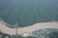
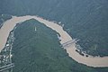
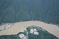
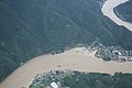
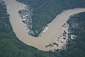
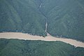
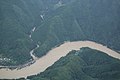
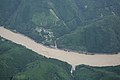
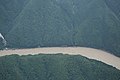
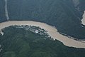
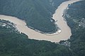
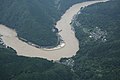
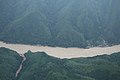
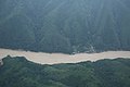
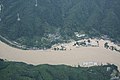
Category:Aerial photographs of July 2020 Kuma River flood by GSI
Media in category "Aerial photographs of July 2020 Kuma River flood by GSI"
The following 200 files are in this category, out of 250 total.
(previous page) (next page)-
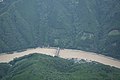
 令和2年(2020年)7月3日からの大雨・斜め写真・球磨川地区(熊本県八代市、芦北町、球磨村)124A2467.jpg 2,880 × 1,920; 2.84 MB
-
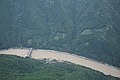
 令和2年(2020年)7月3日からの大雨・斜め写真・球磨川地区(熊本県八代市、芦北町、球磨村)124A2468.jpg 2,880 × 1,920; 2.83 MB
-
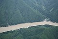
 令和2年(2020年)7月3日からの大雨・斜め写真・球磨川地区(熊本県八代市、芦北町、球磨村)124A2469.jpg 2,880 × 1,920; 2.77 MB
-
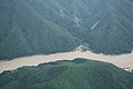
 令和2年(2020年)7月3日からの大雨・斜め写真・球磨川地区(熊本県八代市、芦北町、球磨村)124A2470.jpg 2,880 × 1,920; 2.82 MB
-
 令和2年(2020年)7月3日からの大雨・斜め写真・球磨川地区(熊本県八代市、芦北町、球磨村)124A2471.jpg 2,880 × 1,920; 2.84 MB
-
 令和2年(2020年)7月3日からの大雨・斜め写真・球磨川地区(熊本県八代市、芦北町、球磨村)124A2472.jpg 2,880 × 1,920; 2.98 MB
-
 令和2年(2020年)7月3日からの大雨・斜め写真・球磨川地区(熊本県八代市、芦北町、球磨村)124A2473.jpg 2,880 × 1,920; 3.02 MB
-
 令和2年(2020年)7月3日からの大雨・斜め写真・球磨川地区(熊本県八代市、芦北町、球磨村)124A2474.jpg 2,880 × 1,920; 3 MB
-
 令和2年(2020年)7月3日からの大雨・斜め写真・球磨川地区(熊本県八代市、芦北町、球磨村)124A2475.jpg 2,880 × 1,920; 2.92 MB
-
 令和2年(2020年)7月3日からの大雨・斜め写真・球磨川地区(熊本県八代市、芦北町、球磨村)124A2476.jpg 2,880 × 1,920; 2.99 MB
-
 令和2年(2020年)7月3日からの大雨・斜め写真・球磨川地区(熊本県八代市、芦北町、球磨村)124A2477.jpg 2,880 × 1,920; 3.14 MB
-
 令和2年(2020年)7月3日からの大雨・斜め写真・球磨川地区(熊本県八代市、芦北町、球磨村)124A2479.jpg 2,880 × 1,920; 2.78 MB
-
 令和2年(2020年)7月3日からの大雨・斜め写真・球磨川地区(熊本県八代市、芦北町、球磨村)124A2480.jpg 2,880 × 1,920; 2.76 MB
-
 令和2年(2020年)7月3日からの大雨・斜め写真・球磨川地区(熊本県八代市、芦北町、球磨村)124A2481.jpg 2,880 × 1,920; 2.75 MB
-
 令和2年(2020年)7月3日からの大雨・斜め写真・球磨川地区(熊本県八代市、芦北町、球磨村)124A2482.jpg 2,880 × 1,920; 2.69 MB
-
 令和2年(2020年)7月3日からの大雨・斜め写真・球磨川地区(熊本県八代市、芦北町、球磨村)124A2483.jpg 2,880 × 1,920; 2.71 MB
-
 令和2年(2020年)7月3日からの大雨・斜め写真・球磨川地区(熊本県八代市、芦北町、球磨村)124A2484.jpg 2,880 × 1,920; 2.77 MB
-
 令和2年(2020年)7月3日からの大雨・斜め写真・球磨川地区(熊本県八代市、芦北町、球磨村)124A2485.jpg 2,880 × 1,920; 2.86 MB
-
 令和2年(2020年)7月3日からの大雨・斜め写真・球磨川地区(熊本県八代市、芦北町、球磨村)124A2486.jpg 2,880 × 1,920; 2.8 MB
-
 令和2年(2020年)7月3日からの大雨・斜め写真・球磨川地区(熊本県八代市、芦北町、球磨村)124A2487.jpg 2,880 × 1,920; 2.84 MB
-
 令和2年(2020年)7月3日からの大雨・斜め写真・球磨川地区(熊本県八代市、芦北町、球磨村)124A2488.jpg 2,880 × 1,920; 2.92 MB
-
 令和2年(2020年)7月3日からの大雨・斜め写真・球磨川地区(熊本県八代市、芦北町、球磨村)124A2489.jpg 2,880 × 1,920; 2.95 MB
-
 令和2年(2020年)7月3日からの大雨・斜め写真・球磨川地区(熊本県八代市、芦北町、球磨村)124A2490.jpg 2,880 × 1,920; 2.98 MB
-
 令和2年(2020年)7月3日からの大雨・斜め写真・球磨川地区(熊本県八代市、芦北町、球磨村)124A2491.jpg 2,880 × 1,920; 2.94 MB
-
 令和2年(2020年)7月3日からの大雨・斜め写真・球磨川地区(熊本県八代市、芦北町、球磨村)124A2492.jpg 2,880 × 1,920; 3 MB
-
 令和2年(2020年)7月3日からの大雨・斜め写真・球磨川地区(熊本県八代市、芦北町、球磨村)124A2493.jpg 2,880 × 1,920; 2.98 MB
-
 令和2年(2020年)7月3日からの大雨・斜め写真・球磨川地区(熊本県八代市、芦北町、球磨村)124A2494.jpg 2,880 × 1,920; 2.87 MB
-
 令和2年(2020年)7月3日からの大雨・斜め写真・球磨川地区(熊本県八代市、芦北町、球磨村)124A2495.jpg 2,880 × 1,920; 2.78 MB
-
 令和2年(2020年)7月3日からの大雨・斜め写真・球磨川地区(熊本県八代市、芦北町、球磨村)124A2496.jpg 2,880 × 1,920; 2.77 MB
-
 令和2年(2020年)7月3日からの大雨・斜め写真・球磨川地区(熊本県八代市、芦北町、球磨村)124A2497.jpg 2,880 × 1,920; 2.78 MB
-
 令和2年(2020年)7月3日からの大雨・斜め写真・球磨川地区(熊本県八代市、芦北町、球磨村)124A2498.jpg 2,880 × 1,920; 2.85 MB
-
 令和2年(2020年)7月3日からの大雨・斜め写真・球磨川地区(熊本県八代市、芦北町、球磨村)124A2499.jpg 2,880 × 1,920; 2.83 MB
-
 令和2年(2020年)7月3日からの大雨・斜め写真・球磨川地区(熊本県八代市、芦北町、球磨村)124A2500.jpg 2,880 × 1,920; 2.77 MB
-
 令和2年(2020年)7月3日からの大雨・斜め写真・球磨川地区(熊本県八代市、芦北町、球磨村)124A2501.jpg 2,880 × 1,920; 2.73 MB
-
 令和2年(2020年)7月3日からの大雨・斜め写真・球磨川地区(熊本県八代市、芦北町、球磨村)124A2502.jpg 2,880 × 1,920; 2.79 MB
-
 令和2年(2020年)7月3日からの大雨・斜め写真・球磨川地区(熊本県八代市、芦北町、球磨村)124A2503.jpg 2,880 × 1,920; 2.77 MB
-
 令和2年(2020年)7月3日からの大雨・斜め写真・球磨川地区(熊本県八代市、芦北町、球磨村)124A2504.jpg 2,880 × 1,920; 2.58 MB
-
 令和2年(2020年)7月3日からの大雨・斜め写真・球磨川地区(熊本県八代市、芦北町、球磨村)124A2505.jpg 2,880 × 1,920; 2.6 MB
-
 令和2年(2020年)7月3日からの大雨・斜め写真・球磨川地区(熊本県八代市、芦北町、球磨村)124A2506.jpg 2,880 × 1,920; 2.75 MB
-
 令和2年(2020年)7月3日からの大雨・斜め写真・球磨川地区(熊本県八代市、芦北町、球磨村)124A2507.jpg 2,880 × 1,920; 2.63 MB
-
 令和2年(2020年)7月3日からの大雨・斜め写真・球磨川地区(熊本県八代市、芦北町、球磨村)124A2508.jpg 2,880 × 1,920; 2.28 MB
-
 令和2年(2020年)7月3日からの大雨・斜め写真・球磨川地区(熊本県八代市、芦北町、球磨村)124A2509.jpg 2,880 × 1,920; 2.42 MB
-
 令和2年(2020年)7月3日からの大雨・斜め写真・球磨川地区(熊本県八代市、芦北町、球磨村)124A2510.jpg 2,880 × 1,920; 2.71 MB
-
 令和2年(2020年)7月3日からの大雨・斜め写真・球磨川地区(熊本県八代市、芦北町、球磨村)124A2511.jpg 2,880 × 1,920; 2.87 MB
-
 令和2年(2020年)7月3日からの大雨・斜め写真・球磨川地区(熊本県八代市、芦北町、球磨村)124A2512.jpg 2,880 × 1,920; 2.85 MB
-
 令和2年(2020年)7月3日からの大雨・斜め写真・球磨川地区(熊本県八代市、芦北町、球磨村)124A2513.jpg 2,880 × 1,920; 2.76 MB
-
 令和2年(2020年)7月3日からの大雨・斜め写真・球磨川地区(熊本県八代市、芦北町、球磨村)124A2514.jpg 2,880 × 1,920; 2.88 MB
-
 令和2年(2020年)7月3日からの大雨・斜め写真・球磨川地区(熊本県八代市、芦北町、球磨村)124A2515.jpg 2,880 × 1,920; 2.84 MB
-
 令和2年(2020年)7月3日からの大雨・斜め写真・球磨川地区(熊本県八代市、芦北町、球磨村)124A2516.jpg 2,880 × 1,920; 2.9 MB
-
 令和2年(2020年)7月3日からの大雨・斜め写真・球磨川地区(熊本県八代市、芦北町、球磨村)124A2517.jpg 2,880 × 1,920; 3.01 MB
-
 令和2年(2020年)7月3日からの大雨・斜め写真・球磨川地区(熊本県八代市、芦北町、球磨村)124A2518.jpg 2,880 × 1,920; 3 MB
-
 令和2年(2020年)7月3日からの大雨・斜め写真・球磨川地区(熊本県八代市、芦北町、球磨村)124A2519.jpg 2,880 × 1,920; 2.94 MB
-
 令和2年(2020年)7月3日からの大雨・斜め写真・球磨川地区(熊本県八代市、芦北町、球磨村)124A2520.jpg 2,880 × 1,920; 2.96 MB
-
 令和2年(2020年)7月3日からの大雨・斜め写真・球磨川地区(熊本県八代市、芦北町、球磨村)124A2521.jpg 2,880 × 1,920; 3.04 MB
-
 令和2年(2020年)7月3日からの大雨・斜め写真・球磨川地区(熊本県八代市、芦北町、球磨村)124A2522.jpg 2,880 × 1,920; 3.1 MB
-
 令和2年(2020年)7月3日からの大雨・斜め写真・球磨川地区(熊本県八代市、芦北町、球磨村)124A2523.jpg 2,880 × 1,920; 3.03 MB
-
 令和2年(2020年)7月3日からの大雨・斜め写真・球磨川地区(熊本県八代市、芦北町、球磨村)124A2524.jpg 2,880 × 1,920; 3.2 MB
-
 令和2年(2020年)7月3日からの大雨・斜め写真・球磨川地区(熊本県八代市、芦北町、球磨村)124A2525.jpg 2,880 × 1,920; 3.13 MB
-
 令和2年(2020年)7月3日からの大雨・斜め写真・球磨川地区(熊本県八代市、芦北町、球磨村)124A2526.jpg 2,880 × 1,920; 3.04 MB
-
 令和2年(2020年)7月3日からの大雨・斜め写真・球磨川地区(熊本県八代市、芦北町、球磨村)124A2527.jpg 2,880 × 1,920; 2.98 MB
-
 令和2年(2020年)7月3日からの大雨・斜め写真・球磨川地区(熊本県八代市、芦北町、球磨村)124A2528.jpg 2,880 × 1,920; 2.84 MB
-
 令和2年(2020年)7月3日からの大雨・斜め写真・球磨川地区(熊本県八代市、芦北町、球磨村)124A2529.jpg 2,880 × 1,920; 2.94 MB
-
 令和2年(2020年)7月3日からの大雨・斜め写真・球磨川地区(熊本県八代市、芦北町、球磨村)124A2530.jpg 2,880 × 1,920; 2.71 MB
-
 令和2年(2020年)7月3日からの大雨・斜め写真・球磨川地区(熊本県八代市、芦北町、球磨村)124A2531.jpg 2,880 × 1,920; 3.03 MB
-
 令和2年(2020年)7月3日からの大雨・斜め写真・球磨川地区(熊本県八代市、芦北町、球磨村)124A2534.jpg 2,880 × 1,920; 3.01 MB
-
 令和2年(2020年)7月3日からの大雨・斜め写真・球磨川地区(熊本県八代市、芦北町、球磨村)124A2535.jpg 2,880 × 1,920; 2.88 MB
-
 令和2年(2020年)7月3日からの大雨・斜め写真・球磨川地区(熊本県八代市、芦北町、球磨村)124A2536.jpg 2,880 × 1,920; 2.88 MB
-
 令和2年(2020年)7月3日からの大雨・斜め写真・球磨川地区(熊本県八代市、芦北町、球磨村)124A2537.jpg 2,880 × 1,920; 2.98 MB
-
 令和2年(2020年)7月3日からの大雨・斜め写真・球磨川地区(熊本県八代市、芦北町、球磨村)124A2538.jpg 2,880 × 1,920; 2.91 MB
-
 令和2年(2020年)7月3日からの大雨・斜め写真・球磨川地区(熊本県八代市、芦北町、球磨村)124A2539.jpg 2,880 × 1,920; 2.96 MB
-
 令和2年(2020年)7月3日からの大雨・斜め写真・球磨川地区(熊本県八代市、芦北町、球磨村)124A2540.jpg 2,880 × 1,920; 2.9 MB
-
 令和2年(2020年)7月3日からの大雨・斜め写真・球磨川地区(熊本県八代市、芦北町、球磨村)124A2541.jpg 2,880 × 1,920; 2.74 MB
-
 令和2年(2020年)7月3日からの大雨・斜め写真・球磨川地区(熊本県八代市、芦北町、球磨村)124A2542.jpg 2,880 × 1,920; 2.8 MB
-
 令和2年(2020年)7月3日からの大雨・斜め写真・球磨川地区(熊本県八代市、芦北町、球磨村)124A2543.jpg 2,880 × 1,920; 2.78 MB
-
 令和2年(2020年)7月3日からの大雨・斜め写真・球磨川地区(熊本県八代市、芦北町、球磨村)124A2544.jpg 2,880 × 1,920; 2.69 MB
-
 令和2年(2020年)7月3日からの大雨・斜め写真・球磨川地区(熊本県八代市、芦北町、球磨村)124A2545.jpg 2,880 × 1,920; 2.95 MB
-
 令和2年(2020年)7月3日からの大雨・斜め写真・球磨川地区(熊本県八代市、芦北町、球磨村)124A2546.jpg 2,880 × 1,920; 2.99 MB
-
 令和2年(2020年)7月3日からの大雨・斜め写真・球磨川地区(熊本県八代市、芦北町、球磨村)124A2547.jpg 2,880 × 1,920; 3.02 MB
-
 令和2年(2020年)7月3日からの大雨・斜め写真・球磨川地区(熊本県八代市、芦北町、球磨村)124A2548.jpg 2,880 × 1,920; 3.08 MB
-
 令和2年(2020年)7月3日からの大雨・斜め写真・球磨川地区(熊本県八代市、芦北町、球磨村)124A2549.jpg 2,880 × 1,920; 3.07 MB
-
 令和2年(2020年)7月3日からの大雨・斜め写真・球磨川地区(熊本県八代市、芦北町、球磨村)124A2550.jpg 2,880 × 1,920; 2.99 MB
-
 令和2年(2020年)7月3日からの大雨・斜め写真・球磨川地区(熊本県八代市、芦北町、球磨村)124A2551.jpg 2,880 × 1,920; 3.15 MB
-
 令和2年(2020年)7月3日からの大雨・斜め写真・球磨川地区(熊本県八代市、芦北町、球磨村)124A2552.jpg 2,880 × 1,920; 3.15 MB
-
 令和2年(2020年)7月3日からの大雨・斜め写真・球磨川地区(熊本県八代市、芦北町、球磨村)124A2553.jpg 2,880 × 1,920; 3.15 MB
-
 令和2年(2020年)7月3日からの大雨・斜め写真・球磨川地区(熊本県八代市、芦北町、球磨村)124A2554.jpg 2,880 × 1,920; 3.1 MB
-
 令和2年(2020年)7月3日からの大雨・斜め写真・球磨川地区(熊本県八代市、芦北町、球磨村)124A2555.jpg 2,880 × 1,920; 3.03 MB
-
 令和2年(2020年)7月3日からの大雨・斜め写真・球磨川地区(熊本県八代市、芦北町、球磨村)124A2556.jpg 2,880 × 1,920; 3.02 MB
-
 令和2年(2020年)7月3日からの大雨・斜め写真・球磨川地区(熊本県八代市、芦北町、球磨村)124A2557.jpg 2,880 × 1,920; 3.01 MB
-
 令和2年(2020年)7月3日からの大雨・斜め写真・球磨川地区(熊本県八代市、芦北町、球磨村)124A2558.jpg 2,880 × 1,920; 3.09 MB
-
 令和2年(2020年)7月3日からの大雨・斜め写真・球磨川地区(熊本県八代市、芦北町、球磨村)124A2559.jpg 2,880 × 1,920; 3.04 MB
-
 令和2年(2020年)7月3日からの大雨・斜め写真・球磨川地区(熊本県八代市、芦北町、球磨村)124A2560.jpg 2,880 × 1,920; 3.03 MB
-
 令和2年(2020年)7月3日からの大雨・斜め写真・球磨川地区(熊本県八代市、芦北町、球磨村)124A2561.jpg 2,880 × 1,920; 2.9 MB
-
 令和2年(2020年)7月3日からの大雨・斜め写真・球磨川地区(熊本県八代市、芦北町、球磨村)124A2562.jpg 2,880 × 1,920; 2.78 MB
-
 令和2年(2020年)7月3日からの大雨・斜め写真・球磨川地区(熊本県八代市、芦北町、球磨村)124A2563.jpg 2,880 × 1,920; 2.6 MB
-
 令和2年(2020年)7月3日からの大雨・斜め写真・球磨川地区(熊本県八代市、芦北町、球磨村)124A2564.jpg 2,880 × 1,920; 2.71 MB
-
 令和2年(2020年)7月3日からの大雨・斜め写真・球磨川地区(熊本県八代市、芦北町、球磨村)124A2565.jpg 2,880 × 1,920; 2.87 MB
-
 令和2年(2020年)7月3日からの大雨・斜め写真・球磨川地区(熊本県八代市、芦北町、球磨村)124A2566.jpg 2,880 × 1,920; 2.84 MB
-
 令和2年(2020年)7月3日からの大雨・斜め写真・球磨川地区(熊本県八代市、芦北町、球磨村)124A2567.jpg 2,880 × 1,920; 2.79 MB
-
 令和2年(2020年)7月3日からの大雨・斜め写真・球磨川地区(熊本県八代市、芦北町、球磨村)124A2568.jpg 2,880 × 1,920; 2.71 MB
-
 令和2年(2020年)7月3日からの大雨・斜め写真・球磨川地区(熊本県八代市、芦北町、球磨村)124A2569.jpg 2,880 × 1,920; 2.65 MB
-
 令和2年(2020年)7月3日からの大雨・斜め写真・球磨川地区(熊本県八代市、芦北町、球磨村)124A2570.jpg 2,880 × 1,920; 2.72 MB
-
 令和2年(2020年)7月3日からの大雨・斜め写真・球磨川地区(熊本県八代市、芦北町、球磨村)124A2571.jpg 2,880 × 1,920; 2.55 MB
-
 令和2年(2020年)7月3日からの大雨・斜め写真・球磨川地区(熊本県八代市、芦北町、球磨村)124A2572.jpg 2,880 × 1,920; 2.57 MB
-
 令和2年(2020年)7月3日からの大雨・斜め写真・球磨川地区(熊本県八代市、芦北町、球磨村)124A2573.jpg 2,880 × 1,920; 2.66 MB
-
 令和2年(2020年)7月3日からの大雨・斜め写真・球磨川地区(熊本県八代市、芦北町、球磨村)124A2574.jpg 2,880 × 1,920; 2.57 MB
-
 令和2年(2020年)7月3日からの大雨・斜め写真・球磨川地区(熊本県八代市、芦北町、球磨村)124A2575.jpg 2,880 × 1,920; 2.2 MB
-
 令和2年(2020年)7月3日からの大雨・斜め写真・球磨川地区(熊本県八代市、芦北町、球磨村)124A2576.jpg 2,880 × 1,920; 2.57 MB
-
 令和2年(2020年)7月3日からの大雨・斜め写真・球磨川地区(熊本県八代市、芦北町、球磨村)124A2577.jpg 2,880 × 1,920; 2.38 MB
-
 令和2年(2020年)7月3日からの大雨・斜め写真・球磨川地区(熊本県八代市、芦北町、球磨村)124A2578.jpg 2,880 × 1,920; 2.54 MB
-
 令和2年(2020年)7月3日からの大雨・斜め写真・球磨川地区(熊本県八代市、芦北町、球磨村)124A2579.jpg 2,880 × 1,920; 2.82 MB
-
 令和2年(2020年)7月3日からの大雨・斜め写真・球磨川地区(熊本県八代市、芦北町、球磨村)124A2580.jpg 2,880 × 1,920; 2.87 MB
-
 令和2年(2020年)7月3日からの大雨・斜め写真・球磨川地区(熊本県八代市、芦北町、球磨村)124A2581.jpg 2,880 × 1,920; 2.89 MB
-
 令和2年(2020年)7月3日からの大雨・斜め写真・球磨川地区(熊本県八代市、芦北町、球磨村)124A2582.jpg 2,880 × 1,920; 2.86 MB
-
 令和2年(2020年)7月3日からの大雨・斜め写真・球磨川地区(熊本県八代市、芦北町、球磨村)124A2583.jpg 2,880 × 1,920; 2.89 MB
-
 令和2年(2020年)7月3日からの大雨・斜め写真・球磨川地区(熊本県八代市、芦北町、球磨村)124A2584.jpg 2,880 × 1,920; 2.93 MB
-
 令和2年(2020年)7月3日からの大雨・斜め写真・球磨川地区(熊本県八代市、芦北町、球磨村)124A2585.jpg 2,880 × 1,920; 2.95 MB
-
 令和2年(2020年)7月3日からの大雨・斜め写真・球磨川地区(熊本県八代市、芦北町、球磨村)124A2586.jpg 2,880 × 1,920; 2.92 MB
-
 令和2年(2020年)7月3日からの大雨・斜め写真・球磨川地区(熊本県八代市、芦北町、球磨村)124A2587.jpg 2,880 × 1,920; 2.9 MB
-
 令和2年(2020年)7月3日からの大雨・斜め写真・球磨川地区(熊本県八代市、芦北町、球磨村)124A2588.jpg 2,880 × 1,920; 2.87 MB
-
 令和2年(2020年)7月3日からの大雨・斜め写真・球磨川地区(熊本県八代市、芦北町、球磨村)124A2589.jpg 2,880 × 1,920; 2.64 MB
-
 令和2年(2020年)7月3日からの大雨・斜め写真・球磨川地区(熊本県八代市、芦北町、球磨村)124A2590.jpg 2,880 × 1,920; 2.57 MB
-
 令和2年(2020年)7月3日からの大雨・斜め写真・球磨川地区(熊本県八代市、芦北町、球磨村)124A2591.jpg 2,880 × 1,920; 2.3 MB
-
 令和2年(2020年)7月3日からの大雨・斜め写真・球磨川地区(熊本県八代市、芦北町、球磨村)124A2592.jpg 2,880 × 1,920; 2.51 MB
-
 令和2年(2020年)7月3日からの大雨・斜め写真・球磨川地区(熊本県八代市、芦北町、球磨村)124A2593.jpg 2,880 × 1,920; 2.37 MB
-
 令和2年(2020年)7月3日からの大雨・斜め写真・球磨川地区(熊本県八代市、芦北町、球磨村)124A2594.jpg 2,880 × 1,920; 2.47 MB
-
 令和2年(2020年)7月3日からの大雨・斜め写真・球磨川地区(熊本県八代市、芦北町、球磨村)124A2595.jpg 2,880 × 1,920; 2.47 MB
-
 令和2年(2020年)7月3日からの大雨・斜め写真・球磨川地区(熊本県八代市、芦北町、球磨村)124A2596.jpg 2,880 × 1,920; 2.54 MB
-
 令和2年(2020年)7月3日からの大雨・斜め写真・球磨川地区(熊本県八代市、芦北町、球磨村)124A2597.jpg 2,880 × 1,920; 2.69 MB
-
 令和2年(2020年)7月3日からの大雨・斜め写真・球磨川地区(熊本県八代市、芦北町、球磨村)124A2598.jpg 2,880 × 1,920; 2.61 MB
-
 令和2年(2020年)7月3日からの大雨・斜め写真・球磨川地区(熊本県八代市、芦北町、球磨村)124A2599.jpg 2,880 × 1,920; 2.55 MB
-
 令和2年(2020年)7月3日からの大雨・斜め写真・球磨川地区(熊本県八代市、芦北町、球磨村)124A2600.jpg 2,880 × 1,920; 2.41 MB
-
 令和2年(2020年)7月3日からの大雨・斜め写真・球磨川地区(熊本県八代市、芦北町、球磨村)124A2601.jpg 2,880 × 1,920; 2.42 MB
-
 令和2年(2020年)7月3日からの大雨・斜め写真・球磨川地区(熊本県八代市、芦北町、球磨村)124A2602.jpg 2,880 × 1,920; 2.53 MB
-
 令和2年(2020年)7月3日からの大雨・斜め写真・球磨川地区(熊本県八代市、芦北町、球磨村)124A2603.jpg 2,880 × 1,920; 2.7 MB
-
 令和2年(2020年)7月3日からの大雨・斜め写真・球磨川地区(熊本県八代市、芦北町、球磨村)124A2604.jpg 2,880 × 1,920; 2.67 MB
-
 令和2年(2020年)7月3日からの大雨・斜め写真・球磨川地区(熊本県八代市、芦北町、球磨村)124A2605.jpg 2,880 × 1,920; 2.64 MB
-
 令和2年(2020年)7月3日からの大雨・斜め写真・球磨川地区(熊本県八代市、芦北町、球磨村)124A2606.jpg 2,880 × 1,920; 2.65 MB
-
 令和2年(2020年)7月3日からの大雨・斜め写真・球磨川地区(熊本県八代市、芦北町、球磨村)124A2607.jpg 2,880 × 1,920; 2.65 MB
-
 令和2年(2020年)7月3日からの大雨・斜め写真・球磨川地区(熊本県八代市、芦北町、球磨村)124A2608.jpg 2,880 × 1,920; 2.61 MB
-
 令和2年(2020年)7月3日からの大雨・斜め写真・球磨川地区(熊本県八代市、芦北町、球磨村)124A2609.jpg 2,880 × 1,920; 2.55 MB
-
 令和2年(2020年)7月3日からの大雨・斜め写真・球磨川地区(熊本県八代市、芦北町、球磨村)124A2610.jpg 2,880 × 1,920; 2.57 MB
-
 令和2年(2020年)7月3日からの大雨・斜め写真・球磨川地区(熊本県八代市、芦北町、球磨村)124A2611.jpg 2,880 × 1,920; 2.5 MB
-
 令和2年(2020年)7月3日からの大雨・斜め写真・球磨川地区(熊本県八代市、芦北町、球磨村)124A2612.jpg 2,880 × 1,920; 2.47 MB
-
 令和2年(2020年)7月3日からの大雨・斜め写真・球磨川地区(熊本県八代市、芦北町、球磨村)124A2613.jpg 2,880 × 1,920; 1.77 MB
-
 令和2年(2020年)7月3日からの大雨・斜め写真・球磨川地区(熊本県八代市、芦北町、球磨村)124A2614.jpg 2,880 × 1,920; 2.67 MB
-
 令和2年(2020年)7月3日からの大雨・斜め写真・球磨川地区(熊本県八代市、芦北町、球磨村)124A2615.jpg 2,880 × 1,920; 2.53 MB
-
 令和2年(2020年)7月3日からの大雨・斜め写真・球磨川地区(熊本県八代市、芦北町、球磨村)124A2616.jpg 2,880 × 1,920; 1.91 MB
-
 令和2年(2020年)7月3日からの大雨・斜め写真・球磨川地区(熊本県八代市、芦北町、球磨村)124A2617.jpg 2,880 × 1,920; 2.17 MB
-
 令和2年(2020年)7月3日からの大雨・斜め写真・球磨川地区(熊本県八代市、芦北町、球磨村)124A2618.jpg 2,880 × 1,920; 2.97 MB
-
 令和2年(2020年)7月3日からの大雨・斜め写真・球磨川地区(熊本県八代市、芦北町、球磨村)124A2619.jpg 2,880 × 1,920; 2.93 MB
-
 令和2年(2020年)7月3日からの大雨・斜め写真・球磨川地区(熊本県八代市、芦北町、球磨村)124A2620.jpg 2,880 × 1,920; 2.98 MB
-
 令和2年(2020年)7月3日からの大雨・斜め写真・球磨川地区(熊本県八代市、芦北町、球磨村)124A2621.jpg 2,880 × 1,920; 2.99 MB
-
 令和2年(2020年)7月3日からの大雨・斜め写真・球磨川地区(熊本県八代市、芦北町、球磨村)124A2622.jpg 2,880 × 1,920; 2.99 MB
-
 令和2年(2020年)7月3日からの大雨・斜め写真・球磨川地区(熊本県八代市、芦北町、球磨村)124A2623.jpg 2,880 × 1,920; 3.01 MB
-
 令和2年(2020年)7月3日からの大雨・斜め写真・球磨川地区(熊本県八代市、芦北町、球磨村)124A2624.jpg 2,880 × 1,920; 3.04 MB
-
 令和2年(2020年)7月3日からの大雨・斜め写真・球磨川地区(熊本県八代市、芦北町、球磨村)124A2625.jpg 2,880 × 1,920; 2.98 MB
-
 令和2年(2020年)7月3日からの大雨・斜め写真・球磨川地区(熊本県八代市、芦北町、球磨村)124A2626.jpg 2,880 × 1,920; 3 MB
-
 令和2年(2020年)7月3日からの大雨・斜め写真・球磨川地区(熊本県八代市、芦北町、球磨村)124A2627.jpg 2,880 × 1,920; 2.87 MB
-
 令和2年(2020年)7月3日からの大雨・斜め写真・球磨川地区(熊本県八代市、芦北町、球磨村)124A2628.jpg 2,880 × 1,920; 2.82 MB
-
 令和2年(2020年)7月3日からの大雨・斜め写真・球磨川地区(熊本県八代市、芦北町、球磨村)124A2629.jpg 2,880 × 1,920; 2.86 MB
-
 令和2年(2020年)7月3日からの大雨・斜め写真・球磨川地区(熊本県八代市、芦北町、球磨村)124A2630.jpg 2,880 × 1,920; 2.88 MB
-
 令和2年(2020年)7月3日からの大雨・斜め写真・球磨川地区(熊本県八代市、芦北町、球磨村)124A2631.jpg 2,880 × 1,920; 2.84 MB
-
 令和2年(2020年)7月3日からの大雨・斜め写真・球磨川地区(熊本県八代市、芦北町、球磨村)124A2632.jpg 2,880 × 1,920; 2.69 MB
-
 令和2年(2020年)7月3日からの大雨・斜め写真・球磨川地区(熊本県八代市、芦北町、球磨村)124A2633.jpg 2,880 × 1,920; 2.68 MB
-
 令和2年(2020年)7月3日からの大雨・斜め写真・球磨川地区(熊本県八代市、芦北町、球磨村)124A2634.jpg 2,880 × 1,920; 2.79 MB
-
 令和2年(2020年)7月3日からの大雨・斜め写真・球磨川地区(熊本県八代市、芦北町、球磨村)124A2635.jpg 2,880 × 1,920; 1.8 MB
-
 令和2年(2020年)7月3日からの大雨・斜め写真・球磨川地区(熊本県八代市、芦北町、球磨村)124A2636.jpg 2,880 × 1,920; 2.27 MB
-
 令和2年(2020年)7月3日からの大雨・斜め写真・球磨川地区(熊本県八代市、芦北町、球磨村)124A2637.jpg 2,880 × 1,920; 2.74 MB
-
 令和2年(2020年)7月3日からの大雨・斜め写真・球磨川地区(熊本県八代市、芦北町、球磨村)124A2638.jpg 2,880 × 1,920; 2.63 MB
-
 令和2年(2020年)7月3日からの大雨・斜め写真・球磨川地区(熊本県八代市、芦北町、球磨村)124A2639.jpg 2,880 × 1,920; 2.63 MB
-
 令和2年(2020年)7月3日からの大雨・斜め写真・球磨川地区(熊本県八代市、芦北町、球磨村)124A2640.jpg 2,880 × 1,920; 2.63 MB
-
 令和2年(2020年)7月3日からの大雨・斜め写真・球磨川地区(熊本県八代市、芦北町、球磨村)124A2641.jpg 2,880 × 1,920; 2.54 MB
-
 令和2年(2020年)7月3日からの大雨・斜め写真・球磨川地区(熊本県八代市、芦北町、球磨村)124A2642.jpg 2,880 × 1,920; 2.66 MB
-
 令和2年(2020年)7月3日からの大雨・斜め写真・球磨川地区(熊本県八代市、芦北町、球磨村)124A2643.jpg 2,880 × 1,920; 2.73 MB
-
 令和2年(2020年)7月3日からの大雨・斜め写真・球磨川地区(熊本県八代市、芦北町、球磨村)124A2644.jpg 2,880 × 1,920; 2.69 MB
-
 令和2年(2020年)7月3日からの大雨・斜め写真・球磨川地区(熊本県八代市、芦北町、球磨村)124A2645.jpg 2,880 × 1,920; 2.64 MB
-
 令和2年(2020年)7月3日からの大雨・斜め写真・球磨川地区(熊本県八代市、芦北町、球磨村)124A2646.jpg 2,880 × 1,920; 2.73 MB
-
 令和2年(2020年)7月3日からの大雨・斜め写真・球磨川地区(熊本県八代市、芦北町、球磨村)124A2647.jpg 2,880 × 1,920; 2.71 MB
-
 令和2年(2020年)7月3日からの大雨・斜め写真・球磨川地区(熊本県八代市、芦北町、球磨村)124A2648.jpg 2,880 × 1,920; 2.55 MB
-
 令和2年(2020年)7月3日からの大雨・斜め写真・球磨川地区(熊本県八代市、芦北町、球磨村)124A2649.jpg 2,880 × 1,920; 2.52 MB
-
 令和2年(2020年)7月3日からの大雨・斜め写真・球磨川地区(熊本県八代市、芦北町、球磨村)124A2650.jpg 2,880 × 1,920; 2.64 MB
-
 令和2年(2020年)7月3日からの大雨・斜め写真・球磨川地区(熊本県八代市、芦北町、球磨村)124A2651.jpg 2,880 × 1,920; 2.42 MB
-
 令和2年(2020年)7月3日からの大雨・斜め写真・球磨川地区(熊本県八代市、芦北町、球磨村)124A2652.jpg 2,880 × 1,920; 2.27 MB
-
 令和2年(2020年)7月3日からの大雨・斜め写真・球磨川地区(熊本県八代市、芦北町、球磨村)124A2653.jpg 2,880 × 1,920; 2.53 MB
-
 令和2年(2020年)7月3日からの大雨・斜め写真・球磨川地区(熊本県八代市、芦北町、球磨村)124A2654.jpg 2,880 × 1,920; 2.61 MB
-
 令和2年(2020年)7月3日からの大雨・斜め写真・球磨川地区(熊本県八代市、芦北町、球磨村)124A2655.jpg 2,880 × 1,920; 2.66 MB
-
 令和2年(2020年)7月3日からの大雨・斜め写真・球磨川地区(熊本県八代市、芦北町、球磨村)124A2656.jpg 2,880 × 1,920; 2.7 MB
-
 令和2年(2020年)7月3日からの大雨・斜め写真・球磨川地区(熊本県八代市、芦北町、球磨村)124A2657.jpg 2,880 × 1,920; 2.76 MB
-
 令和2年(2020年)7月3日からの大雨・斜め写真・球磨川地区(熊本県八代市、芦北町、球磨村)124A2658.jpg 2,880 × 1,920; 2.72 MB
-
 令和2年(2020年)7月3日からの大雨・斜め写真・球磨川地区(熊本県八代市、芦北町、球磨村)124A2659.jpg 2,880 × 1,920; 2.56 MB
-
 令和2年(2020年)7月3日からの大雨・斜め写真・球磨川地区(熊本県八代市、芦北町、球磨村)124A2660.jpg 2,880 × 1,920; 2.48 MB
-
 令和2年(2020年)7月3日からの大雨・斜め写真・球磨川地区(熊本県八代市、芦北町、球磨村)124A2661.jpg 2,880 × 1,920; 2.58 MB
-
 令和2年(2020年)7月3日からの大雨・斜め写真・球磨川地区(熊本県八代市、芦北町、球磨村)124A2662.jpg 2,880 × 1,920; 2.7 MB
-
 令和2年(2020年)7月3日からの大雨・斜め写真・球磨川地区(熊本県八代市、芦北町、球磨村)124A2663.jpg 2,880 × 1,920; 2.8 MB
-
 令和2年(2020年)7月3日からの大雨・斜め写真・球磨川地区(熊本県八代市、芦北町、球磨村)124A2664.jpg 2,880 × 1,920; 2.87 MB
-
 令和2年(2020年)7月3日からの大雨・斜め写真・球磨川地区(熊本県八代市、芦北町、球磨村)124A2665.jpg 2,880 × 1,920; 2.84 MB
-
 令和2年(2020年)7月3日からの大雨・斜め写真・球磨川地区(熊本県八代市、芦北町、球磨村)124A2666.jpg 2,880 × 1,920; 2.84 MB
-
 令和2年(2020年)7月3日からの大雨・斜め写真・球磨川地区(熊本県八代市、芦北町、球磨村)124A2667.jpg 2,880 × 1,920; 2.69 MB
-
 令和2年(2020年)7月3日からの大雨・斜め写真・球磨川地区(熊本県八代市、芦北町、球磨村)124A2668.jpg 2,880 × 1,920; 2.63 MB
-
 令和2年(2020年)7月3日からの大雨・斜め写真・球磨川地区(熊本県八代市、芦北町、球磨村)124A2669.jpg 2,880 × 1,920; 2.6 MB


