Category:Aerial photographs of Playa de Arena (Santiago del Teide)
| Camera location | | View all coordinates using: OpenStreetMap |
|---|
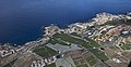
English: Pictures of aerial photographs of Playa de la Arena and Puerto de Santiago belongs to municipality Santiago del Teide on Tenerife one of the islands of the Canary Islands in Spain
Media in category "Aerial photographs of Playa de Arena (Santiago del Teide)"
The following 3 files are in this category, out of 3 total.
-
 A0215 Tenerife, Playa de La Arena aerial view.jpg 7,051 × 3,687; 10.76 MB
-
 A0218 Tenerife, Playa de La Arena and Los Gigantes aerial view.jpg 7,526 × 3,882; 11.31 MB
-
 A0221 Tenerife, Playa de La Arena and Los Gigantes aerial view.jpg 6,320 × 4,513; 11.58 MB


