Category:Aerial photographs of the Scottish Borders
Council areas (municipalities) of Scotland: Aberdeen · Aberdeenshire · Angus · Argyll and Bute · Clackmannanshire · Dumfries and Galloway · Dundee · East Ayrshire · East Dunbartonshire · East Lothian · East Renfrewshire · Edinburgh · Falkirk · Fife · Glasgow · Highland · Inverclyde · Midlothian · Moray · North Ayrshire · North Lanarkshire · Outer Hebrides · Orkney Islands · Perth and Kinross · Renfrewshire · Scottish Borders · Shetland Islands · South Ayrshire · South Lanarkshire · Stirling · West Dunbartonshire · West Lothian
Media in category "Aerial photographs of the Scottish Borders"
The following 11 files are in this category, out of 11 total.
-
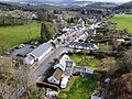 Broughton Village, Scottish Borders.jpg 4,000 × 3,000; 5.75 MB
-
 Fogo Kirk - geograph.org.uk - 194592.jpg 640 × 458; 61 KB
-
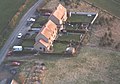
 Newark Castle - geograph.org.uk - 1127867.jpg 629 × 438; 157 KB
-
 Quarry near Penicuik and Eddleston 01.jpg 2,784 × 2,448; 4.04 MB
-
 Quarry near Penicuik and Eddleston 02.jpg 3,180 × 2,380; 6.63 MB
-

-
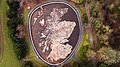 The Great Polish Map of Scotland - geograph.org.uk - 4887145.jpg 660 × 371; 103 KB
-
 The Great Polish Map of Scotland.JPG 4,000 × 2,250; 4.21 MB
-

-
 Rashie Fogo - geograph.org.uk - 194595.jpg 640 × 448; 75 KB
-
 River Tweed - geograph.org.uk - 613782.jpg 640 × 434; 153 KB


