Category:Alesheim
municipality of Germany  .jpg)   | |||||
| Upload media | |||||
| Instance of |
| ||||
|---|---|---|---|---|---|
| Part of |
| ||||
| Location | Weißenburg-Gunzenhausen, Middle Franconia, Bavaria, Germany | ||||
| Head of government |
| ||||
| Population |
| ||||
| Area |
| ||||
| Elevation above sea level |
| ||||
| official website | |||||
 | |||||
Subcategories
This category has the following 3 subcategories, out of 3 total.
C
Media in category "Alesheim"
The following 8 files are in this category, out of 8 total.
-
 Wappen Alesheim.svg 735 × 701; 20 KB
-
 Wappen von Alesheim.png 150 × 160; 6 KB
-
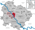 Alesheim in WUG.svg 611 × 532; 1.02 MB
-
 Alesheim Luftaufnahme (2020).jpg 3,781 × 2,388; 3.35 MB
-
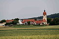 Alesheim X.JPG 4,752 × 3,168; 370 KB
-
 Flüglinger Berg Luftaufnahme (2020).jpg 3,943 × 2,162; 2.59 MB
-

-
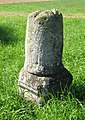 Vermessungsstein WUG4 Tromm.jpg 1,104 × 1,558; 768 KB

.jpg)
.jpg)
