Category:Alford, Lincolnshire
English: Alford (pronounced "Olford") is a town in Lincolnshire, England, with a population of about 3,500. Alford lies at the foot of the Lincolnshire Wolds, north-west of Skegness.
Esperanto: Alford estas malgranda urbo en la angla provinco Lincolnshire.
Română: Alford este un oraş în comitatul Lincolnshire, regiunea East Midlands, Anglia. Oraşul se află în districtul East Lindsey.
town and civil parish in Lincolnshire, England  | |||||
| Upload media | |||||
| Instance of | |||||
|---|---|---|---|---|---|
| Location | East Lindsey, Lincolnshire, East Midlands, England | ||||
| Said to be the same as | Alford (Wikimedia duplicated page, civil parish) | ||||
| official website | |||||
 | |||||
Subcategories
This category has the following 7 subcategories, out of 7 total.
Media in category "Alford, Lincolnshire"
The following 99 files are in this category, out of 99 total.
-
 118 West Street Alford - geograph.org.uk - 3651174.jpg 5,184 × 3,456; 6.94 MB
-
 12 South Market Place, Alford (geograph 7212738).jpg 1,024 × 768; 148 KB
-
 16 Church Street, Alford - geograph.org.uk - 6268841.jpg 5,184 × 3,456; 6.08 MB
-
 1914-1918 House near Alford Station - geograph.org.uk - 3861594.jpg 640 × 427; 82 KB
-
 26 to 28 South Market Place - geograph.org.uk - 3651868.jpg 5,063 × 3,369; 4.17 MB
-
 29 West Street, Alford - geograph.org.uk - 6270544.jpg 3,888 × 2,592; 2.76 MB
-
 6 High Street - geograph.org.uk - 3651108.jpg 4,803 × 4,100; 5.3 MB
-

-

-
 A1111 entering Alford from Bilsby - geograph.org.uk - 3005516.jpg 640 × 496; 110 KB
-
 Acacia Cottage 112 West Street - geograph.org.uk - 3651205.jpg 5,184 × 3,456; 6.56 MB
-
 Aglais io - geograph.org.uk - 469867.jpg 640 × 480; 82 KB
-
-
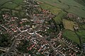
 Alford centre, aerial 2017 (1) - geograph.org.uk - 5361484.jpg 640 × 427; 88 KB
-
 Alford centre, aerial 2017 (2) - geograph.org.uk - 5361500.jpg 1,024 × 683; 173 KB
-
 Alford centre, aerial 2018 - geograph.org.uk - 5940875.jpg 640 × 427; 80 KB
-
 Alford fire station - geograph.org.uk - 2024704.jpg 640 × 427; 177 KB
-
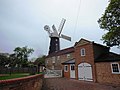
 Alford Mill - geograph.org.uk - 3970519.jpg 1,600 × 1,064; 567 KB
-
 Alford mill - geograph.org.uk - 4071222.jpg 1,024 × 667; 145 KB
-
 Alford Mill - Meal Floor - geograph.org.uk - 3976895.jpg 1,064 × 1,600; 300 KB
-
 Alford windmill - geograph.org.uk - 6213040.jpg 683 × 1,024; 165 KB
-
 Alford windmill, 1984 - geograph.org.uk - 5503897.jpg 640 × 440; 43 KB
-
 Alford windmill, aerial - geograph.org.uk - 3084615.jpg 640 × 427; 47 KB
-
 Alford windmill, aerial 2013 - geograph.org.uk - 3665741.jpg 640 × 427; 91 KB
-
 Alford Windmill, Lincs - geograph.org.uk - 3761038.jpg 768 × 1,024; 185 KB
-
 Alloa Cottage 116 West Street Alford - geograph.org.uk - 3651181.jpg 5,184 × 3,456; 6.87 MB
-

-
 Cemetery Chapel - geograph.org.uk - 2054743.jpg 640 × 426; 99 KB
-

-
 Christmas in Church Street, Alford - geograph.org.uk - 3260593.jpg 640 × 427; 67 KB
-
 Church view down Windmill Lane - geograph.org.uk - 3584554.jpg 640 × 427; 93 KB
-
 Co-op Foodstore, Church Street - geograph.org.uk - 3651057.jpg 5,184 × 3,456; 6.17 MB
-
 Coalyard entrance (geograph 6649913).jpg 6,189 × 4,066; 4.54 MB
-
 Common Darter in Alford Car Park - geograph.org.uk - 469717.jpg 640 × 480; 77 KB
-

-
 Cricket Pavilion at Well - geograph.org.uk - 2380231.jpg 3,296 × 2,472; 1.88 MB
-

-
 Cut-through off Christopher Road - geograph.org.uk - 5548952.jpg 1,280 × 960; 459 KB
-

-
 Drain next to car park, Alford - geograph.org.uk - 6108637.jpg 5,179 × 3,451; 5 MB
-
 Drinking fountain, Market Place, Alford (geograph 7213318).jpg 1,024 × 768; 215 KB
-
 East Street (A1104) in Alford - geograph.org.uk - 6074941.jpg 4,000 × 3,000; 2.63 MB
-
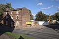
 Empty shops (geograph 6651494).jpg 4,163 × 6,251; 3.23 MB
-
 Feather in the woods at Alford - geograph.org.uk - 471387.jpg 640 × 480; 46 KB
-

-
 Five Sailed Windmill, Alford - geograph.org.uk - 3464525.jpg 4,608 × 3,456; 3.42 MB
-
 Footpath and crop field - geograph.org.uk - 3070164.jpg 2,256 × 1,504; 1.44 MB
-
 Former Church on West Street, Alford - geograph.org.uk - 4152757.jpg 1,600 × 1,200; 443 KB
-
 Former Lloyd's Bank (geograph 6646918).jpg 5,885 × 4,054; 2.85 MB
-
 Free parking over the bridge - geograph.org.uk - 3260600.jpg 640 × 427; 72 KB
-
 Fungi in the woods at Alford - geograph.org.uk - 469807.jpg 640 × 480; 73 KB
-

-
 Glass shelter, South Street, Alford - geograph.org.uk - 6108654.jpg 5,184 × 3,456; 7.07 MB
-
 Half Moon Hotel and Restaurant, 25-28 West Street, Alford - geograph.org.uk - 6270569.jpg 3,888 × 2,592; 3.04 MB
-
 House opposite old Alford Station - geograph.org.uk - 3861593.jpg 1,024 × 683; 160 KB
-
 Houses on the A1104 near the old Alford Station - geograph.org.uk - 3861592.jpg 1,024 × 683; 133 KB
-
 Ivy House (geograph 6649910).jpg 6,166 × 4,032; 3.8 MB
-
 Ivy House 12 Church Street - geograph.org.uk - 3642838.jpg 3,456 × 5,184; 7.28 MB
-
-
 Lichen on a small branch - geograph.org.uk - 469772.jpg 640 × 480; 35 KB
-
 Lloyds TSB 13 Market Place - geograph.org.uk - 3651850.jpg 3,456 × 5,184; 6.03 MB
-

-
 Market Place Alford - geograph.org.uk - 3005544.jpg 640 × 480; 79 KB
-
 Market Square, Alford - geograph.org.uk - 3584559.jpg 640 × 427; 79 KB
-

-

-

-
 Old school building for sale - geograph.org.uk - 3861589.jpg 1,024 × 683; 137 KB
-
 Ordnance Survey Cut Mark - geograph.org.uk - 6087734.jpg 4,000 × 3,000; 4.77 MB
-
 Overspill Car Park, Alford - geograph.org.uk - 423047.jpg 640 × 480; 79 KB
-
 Polygonia c-album - geograph.org.uk - 469870.jpg 640 × 480; 95 KB
-
 Post Office 123 High Street - geograph.org.uk - 3651123.jpg 3,456 × 5,184; 6.5 MB
-
 River through Alford, after heavy rain - geograph.org.uk - 3260616.jpg 640 × 427; 129 KB
-
 Road (and footpath) to Tothby Manor - geograph.org.uk - 3868706.jpg 640 × 427; 43 KB
-
 Road signage in Alford - geograph.org.uk - 2815717.jpg 2,525 × 1,965; 1.14 MB
-
 Robinson Avenue joining Tothby Lane in Alford - geograph.org.uk - 6074959.jpg 4,000 × 3,000; 3.34 MB
-
 Round the back of the White Horse - geograph.org.uk - 3861586.jpg 1,024 × 683; 132 KB
-
 South Street (B1196) in Alford - geograph.org.uk - 6074951.jpg 4,000 × 3,000; 2.71 MB
-
 St Wilfrid's Church Church Street Alford - geograph.org.uk - 6268760.jpg 5,184 × 3,456; 6.01 MB
-
 Telephone Exchange - geograph.org.uk - 3861590.jpg 640 × 427; 44 KB
-
 The Five Sailed Windmill, Alford - geograph.org.uk - 5417799.jpg 480 × 640; 73 KB
-
 The George Inn 13-14 High Street Alford - geograph.org.uk - 6268730.jpg 5,881 × 3,476; 6.37 MB
-
 The Handyman - geograph.org.uk - 3584532.jpg 640 × 427; 65 KB
-
 The Studio Coffee House 17 Market Place - geograph.org.uk - 3651815.jpg 3,456 × 5,184; 4.98 MB
-
 The Windmill Hotel 10 Market Place - geograph.org.uk - 3642685.jpg 5,184 × 3,456; 4.7 MB
-
 The Wool Factory, 5 Market Place, Alford - geograph.org.uk - 6270709.jpg 3,888 × 2,592; 3.11 MB
-
 The writing's on the wall - geograph.org.uk - 3861596.jpg 640 × 427; 58 KB
-
 Tothby Lane in Alford - geograph.org.uk - 6074964.jpg 4,000 × 3,000; 3.53 MB
-

-
 Twice closed (geograph 6647346).jpg 5,858 × 3,949; 3.61 MB
-
 Umbellifer in the woods at Alford - geograph.org.uk - 469842.jpg 640 × 480; 76 KB
-

-
 War Memorial St Wilfrid's Churchyard Church Street Alford - geograph.org.uk - 6268762.jpg 3,456 × 5,184; 5.75 MB
-
 Well Turn - geograph.org.uk - 231885.jpg 640 × 480; 91 KB
-
 Well Vale Hall, 2012 aerial-geograph-3087618.jpg 640 × 427; 72 KB
-
 West Street, Alford - geograph.org.uk - 4368450.jpg 2,000 × 1,408; 1.05 MB
-

-
 White Horse Hotel 29 West Street - geograph.org.uk - 3651798.jpg 6,529 × 2,681; 4.11 MB
-
 Wildflower verge, Alford - geograph.org.uk - 6213042.jpg 1,024 × 683; 181 KB

.jpg)


_-_geograph.org.uk_-_5361484.jpg)
_-_geograph.org.uk_-_5361500.jpg)


.jpg)


.jpg)
_in_Alford_-_geograph.org.uk_-_6074941.jpg)


.jpg)


.jpg)


_to_Tothby_Manor_-_geograph.org.uk_-_3868706.jpg)


_in_Alford_-_geograph.org.uk_-_6074951.jpg)


.jpg)


.jpg)