Category:Allée couverte du Grand Village
|
This building is indexed in the base Mérimée, a database of architectural heritage maintained by the French Ministry of Culture, under the reference IA00010170
|
| Object location | | View all coordinates using: OpenStreetMap |
|---|
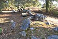
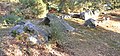
gallery grave in Caro, France  | |||||
| Upload media | |||||
| Instance of | |||||
|---|---|---|---|---|---|
| Location | Caro, Morbihan, Brittany, Q88521114, Metropolitan France, France | ||||
| Heritage designation | |||||
 | |||||
Media in category "Allée couverte du Grand Village"
The following 6 files are in this category, out of 6 total.
-
 Allee Couverte Caro.jpg 2,272 × 1,704; 3.01 MB
-
 Caro grand-village 03.jpg 4,608 × 3,072; 3.55 MB
-
 Caro grand-village 04.jpg 3,914 × 4,477; 3.37 MB
-
 Caro grand-village 05.jpg 4,608 × 3,072; 3.49 MB
-
 Caro grand-village 06.jpg 3,603 × 4,431; 3.29 MB
-
 Caro grand-village 07.jpg 6,505 × 3,017; 3.85 MB


