Category:Alpe Nesdale
|
Alpe Nesdale has an entry on OpenStreetMap (show). |
mountain pasture in the Italian municipality of Plesio      | |||||
| Upload media | |||||
| Instance of | |||||
|---|---|---|---|---|---|
| Location | Plesio, Province of Como, Lombardy, Italy | ||||
| Elevation above sea level |
| ||||
 | |||||
Italiano: L'Alpe Nesdale (1612 m.) è un alpeggio in Val Sanagra, nel comune di Plesio.
Subcategories
This category has the following 4 subcategories, out of 4 total.
Media in category "Alpe Nesdale"
The following 11 files are in this category, out of 11 total.
-
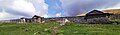 Alpe Nesdale seen from SW.jpg 5,078 × 1,479; 3.3 MB
-
 Alpe Nesdale, as seen arriving from Alpe Pisanera.jpg 3,322 × 1,378; 2.01 MB
-
 Alpe Nesdale, seen from east.jpg 3,059 × 1,329; 2.39 MB
-
 Alpe Nesdale, view from east.jpg 3,853 × 1,380; 3.04 MB
-
 Baita Nesdale, at Alpe Nesdale.jpg 4,659 × 2,454; 4.54 MB
-
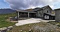
 Building at Alpe Nesdale, NE side.jpg 5,522 × 2,196; 5.42 MB
-
 Building at Alpe Nesdale, SW side.jpg 5,263 × 1,766; 4.66 MB
-
 Entrance to Baita Nesdale, at Alpe Nesdale.jpg 2,516 × 2,816; 3.63 MB
-
 Information board affixed on Baita Nesdale.jpg 1,007 × 741; 261 KB
-
 Photosphere at Alpe Nesdale.jpg 5,322 × 2,661; 5.6 MB
-
 Roof with painted name at Alpe Nesdale.jpg 3,648 × 2,736; 4.25 MB


