Category:Alte Ganterbrücke
| Object location | | View all coordinates using: OpenStreetMap |
|---|
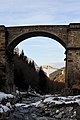
English: The bridge was erected as part of the Simplon road built 1801–1805 by Napoleon I. The bridges had to grab a quick destructive way a middle section made of wood. The stone (concrete) arch was built later.
Deutsch: Die Brücke wurde im Zuge der Simplonstraße erstellt, die Napoleon I. 1801–1805 bauen ließ. Die Brücken hatten zwecks rascherer Zerstörungsmöglichkeit einen Mittelteil aus Holz. Der steinerne (betonierte) Bogen wurde später eingebaut.
Road bridge in Brig-Glis, Valais, Switzerland; Brig-Glis, Valais, Switzerland  | |||||
| Upload media | |||||
| Instance of | |||||
|---|---|---|---|---|---|
| Location | Ried-Brig, Brig District, Valais, Switzerland | ||||
| Crosses |
| ||||
 | |||||
Media in category "Alte Ganterbrücke"
The following 18 files are in this category, out of 18 total.
-
 2007-07-08 DSC 0008 Pont du Kanter Ancien CH-3907 Simplon.JPG 1,936 × 1,296; 1.34 MB
-
 Alte Ganterbruecke 01 11.jpg 1,575 × 1,049; 692 KB
-
 Alte Ganterbruecke 02 11.jpg 1,575 × 1,049; 608 KB
-
 Alte Ganterbruecke 03 11.jpg 1,049 × 1,575; 677 KB
-
 Alte Ganterbruecke 04 11.jpg 1,575 × 1,049; 886 KB
-
 Alte Ganterbruecke 05 11.jpg 1,575 × 1,049; 1.29 MB
-
 Alte Ganterbruecke 06 11.jpg 1,575 × 1,049; 805 KB
-
 Alte Ganterbruecke 07 11.jpg 1,575 × 1,049; 839 KB
-
 Alte Ganterbruecke 08 11.jpg 1,049 × 1,575; 890 KB
-
 Alte Ganterbruecke 09 11.jpg 1,049 × 1,575; 1.05 MB
-
 Alte Ganterbruecke 10 11.jpg 1,575 × 1,049; 893 KB
-

-
 CH-NB-Album -Mit schweizerischen und ausländischen Ansichten--nbdig-18629-page193.tif 3,217 × 2,390; 7.67 MB
-
 CH-NB-La Suisse en miniature-19522-page167.tif 4,075 × 3,414; 12.37 MB
-
 Leopoldo Metlicovitz, 1906 - ponte-di-crevola-berisal.png 1,181 × 767; 1.18 MB
-
 Simplon Pass Berisal Valais Alps of Switzerland.jpg 1,068 × 835; 177 KB
-
 Simplon Pass, Berisal, Valais, Alps of, Switzerland-LCCN2001703322.jpg 3,670 × 2,738; 3.27 MB
-
 Simplon Pass, Berisal, Valais, Alps of, Switzerland-LCCN2001703322.tif 3,670 × 2,738; 28.75 MB


