Category:Altenwerder Unterfeuer
| Object location | | View all coordinates using: OpenStreetMap |
|---|
lighthouse in Hamburg, Germany  | |||||
| Upload media | |||||
| Instance of | |||||
|---|---|---|---|---|---|
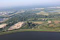
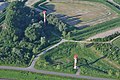
| Location | Moorburg, Harburg, Hamburg, Germany | ||||
| Located in or next to body of water | |||||
| Inception |
| ||||
 | |||||
Media in category "Altenwerder Unterfeuer"
The following 12 files are in this category, out of 12 total.
-
 Altenwerder 013.jpg 1,600 × 1,200; 473 KB
-
 Container-Terminal-Altenwerder-CTA-2004.jpg 1,400 × 938; 774 KB
-
 HP L4425.JPG 5,760 × 3,840; 7.85 MB
-
 Leuchtfeuer (Hamburg-Moorburg).1.phb.ajb.jpg 4,106 × 2,727; 8.57 MB
-
 Leuchtfeuer (Hamburg-Moorburg).2.phb.ajb.jpg 4,148 × 2,755; 8.77 MB
-
 2013-06-08 Projekt Heißlufftballon DSCF7666.jpg 2,500 × 1,673; 3.34 MB
-
 Moorburg, Hamburg, Germany - panoramio (1).jpg 3,080 × 4,120; 4.1 MB
-
 Projekt Heißluftballon-IMG-1320.jpg 3,155 × 4,732; 14.78 MB
-
 Richtfeuer Altenwerder (Hamburg-Moorburg).1.phb.ajb.jpg 2,818 × 4,243; 12.34 MB
-
 Richtfeuer Altenwerder (Hamburg-Moorburg).2.phb.ajb.jpg 4,288 × 2,848; 9.95 MB
-
 Richtfeuer Altenwerder (Hamburg-Moorburg).3.phb.ajb.jpg 4,288 × 2,848; 9.02 MB
-
 Richtfeuer Ellerholz in Hamburg-Moorburg.jpg 4,608 × 3,456; 11.52 MB


.1.phb.ajb.jpg)
.2.phb.ajb.jpg)

.jpg)

.1.phb.ajb.jpg)
.2.phb.ajb.jpg)
.3.phb.ajb.jpg)
