Category:Alton, Wiltshire
English: Alton is a civil parish in the English county of Wiltshire. It comprises the 'twin' villages of Alton Barnes and Alton Priors, together with the nearby hamlet of Honeystreet on the Kennet and Avon Canal.
Nederlands: Alton is een civil parish in de unitary authority Wiltshire, in het Engelse graafschap Wiltshire.
civil parish in Wiltshire, UK  | |||||
| Upload media | |||||
| Instance of | |||||
|---|---|---|---|---|---|
| Location | Wiltshire, South West England, England | ||||
| official website | |||||
 | |||||
Subcategories
This category has the following 4 subcategories, out of 4 total.
A
W
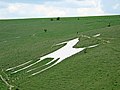
- Alton Barnes White Horse (20 F)
Media in category "Alton, Wiltshire"
The following 200 files are in this category, out of 409 total.
(previous page) (next page)-
 2011 , Lane to West Stowell on a grey day - geograph.org.uk - 2707620.jpg 2,621 × 2,346; 2.2 MB
-
 A bullock, two hikers and a cloud - geograph.org.uk - 4614542.jpg 1,600 × 1,022; 131 KB
-
 A fine downland vista - geograph.org.uk - 5432442.jpg 4,320 × 3,240; 3.66 MB
-

-
 A muddy gateway - geograph.org.uk - 5670004.jpg 640 × 480; 184 KB
-
 A view over the gorse into the Vale of Pewsey - geograph.org.uk - 2380939.jpg 1,920 × 1,280; 1.36 MB
-
 Adam's Grave on Walkers Hill - geograph.org.uk - 5670894.jpg 640 × 480; 117 KB
-

-
 All Saints, Alton Priors, churchyard (i) - geograph.org.uk - 4288726.jpg 640 × 480; 130 KB
-

-

-

-

-
 All Saints, Alton Priors, churchyard (v) - geograph.org.uk - 4288731.jpg 640 × 480; 116 KB
-

-

-

-
 All Saints, Alton Priors, churchyard (x) - geograph.org.uk - 4288738.jpg 640 × 480; 138 KB
-

-

-
 All Saints, Alton Priors, font - geograph.org.uk - 4288757.jpg 640 × 480; 40 KB
-
 All Saints, Alton Priors, gate - geograph.org.uk - 4288745.jpg 478 × 640; 112 KB
-

-

-

-
-

-

-

-

-

-

-

-

-

-
 All Saints, Alton Priors, tower (I) - geograph.org.uk - 4288747.jpg 480 × 640; 137 KB
-
 All Saints, Alton Priors, tower (II) - geograph.org.uk - 4288749.jpg 480 × 640; 78 KB
-

-
 Along the bank - geograph.org.uk - 5654230.jpg 4,320 × 3,240; 4.78 MB
-
 Alton Barnes Turnstile - geograph.org.uk - 3344726.jpg 4,864 × 3,648; 1.65 MB
-
 Alton Barnes White Horse (zoom shot) - geograph.org.uk - 3142833.jpg 1,844 × 1,382; 472 KB
-
 Alton Barnes White Horse - 1 - geograph.org.uk - 1913251.jpg 640 × 480; 99 KB
-
 Alton Barnes White Horse - 2 - geograph.org.uk - 1913256.jpg 640 × 480; 88 KB
-
 Alton Barnes White Horse - geograph.org.uk - 3142829.jpg 1,740 × 1,305; 947 KB
-
 Alton Barnes White Horse - geograph.org.uk - 5436734.jpg 1,024 × 768; 159 KB
-
 Alton Barnes White Horse - geograph.org.uk - 6190728.jpg 1,024 × 678; 1.07 MB
-
 Alton Barns - White Horse - geograph.org.uk - 2834058.jpg 800 × 600; 150 KB
-
 Alton Priors Manor (1) - geograph.org.uk - 5669036.jpg 4,320 × 3,240; 3.96 MB
-
 Alton Priors Manor (2) - geograph.org.uk - 5669039.jpg 4,320 × 3,240; 4.25 MB
-
 Alton Priors Manor (3) - geograph.org.uk - 5669041.jpg 4,320 × 3,240; 2.39 MB
-
 Alton Valley bridge (no 123) - geograph.org.uk - 3704150.jpg 1,024 × 768; 144 KB
-

-

-
 Ascending the Wiltshire Downs - geograph.org.uk - 5669999.jpg 640 × 428; 84 KB
-
 Ascending the Wiltshire Downs - geograph.org.uk - 5670002.jpg 640 × 428; 147 KB
-
 Bales and White Horse - geograph.org.uk - 5283449.jpg 1,024 × 710; 216 KB
-
 Barge moored by the Barge Inn - geograph.org.uk - 2705714.jpg 1,600 × 1,200; 427 KB
-
 Barn at Alton Priors Farm (geograph 5669070).jpg 4,320 × 3,240; 2.72 MB
-
 Barns and bridleway, Woodborough - geograph.org.uk - 844057.jpg 640 × 480; 169 KB
-
 Barrows Above Alton Priors - geograph.org.uk - 6002096.jpg 1,600 × 1,066; 478 KB
-
 Beware of the bull - geograph.org.uk - 4497498.jpg 4,320 × 3,240; 4.96 MB
-
 Bluebells near the Wansdyke - geograph.org.uk - 1906374.jpg 640 × 480; 181 KB
-
 Bridleway leaves the road - geograph.org.uk - 5669085.jpg 4,320 × 3,240; 4.24 MB
-
 Browns Cottage - geograph.org.uk - 5669050.jpg 4,320 × 3,240; 3.32 MB
-
 Browns Lane - geograph.org.uk - 4587660.jpg 640 × 480; 92 KB
-

-

-

-
 Byway at Red Shore - geograph.org.uk - 1906439.jpg 640 × 480; 97 KB
-
 Canal bridge at Honeystreet - geograph.org.uk - 5764828.jpg 640 × 427; 73 KB
-
 Car park from Walkers Hill - geograph.org.uk - 3142814.jpg 1,638 × 1,228; 623 KB
-
 Car park Knap Hill - geograph.org.uk - 4589096.jpg 640 × 457; 78 KB
-
 Carthouse at Alton Priors Farms (geograph 5669072).jpg 4,219 × 3,164; 2.72 MB
-
 Carthouse at Alton Priors Farms (geograph 5669078).jpg 4,320 × 3,240; 3.11 MB
-
 Cattle on the slopes of Knap Hill - geograph.org.uk - 1914067.jpg 640 × 433; 87 KB
-
 Cattle on tumulus - geograph.org.uk - 6191399.jpg 1,024 × 678; 506 KB
-
 Cattle on tumulus - geograph.org.uk - 6327695.jpg 800 × 600; 137 KB
-
 Cereal crop near Alton Barnes - geograph.org.uk - 6327792.jpg 800 × 600; 112 KB
-
 Chalk Milkwort on the Pewsey Downs - geograph.org.uk - 2381020.jpg 1,920 × 1,280; 608 KB
-
 Chalkpits on Walkers Hill - geograph.org.uk - 1914055.jpg 640 × 433; 113 KB
-
 Church of St. Mary, Alton Barnes - geograph.org.uk - 3362682.jpg 4,864 × 3,648; 3.86 MB
-
 Climbing Walkers Hill, Pewsey Downs - geograph.org.uk - 5436550.jpg 1,024 × 824; 124 KB
-
 Clump of violets on Knap Hill - geograph.org.uk - 2329314.jpg 1,920 × 1,280; 826 KB
-
 Common Pollen Beetle - geograph.org.uk - 2329270.jpg 2,917 × 2,188; 3.6 MB
-
 Common Yellow Dung Fly - geograph.org.uk - 2329137.jpg 1,427 × 1,070; 1.02 MB
-
 Cottage Village Street Alton Barnes - geograph.org.uk - 3330815.jpg 4,864 × 3,235; 6.74 MB
-
 Country road - geograph.org.uk - 4589110.jpg 640 × 480; 49 KB
-
 Cows in pasture near Knap Cottage - geograph.org.uk - 2705570.jpg 1,600 × 1,200; 314 KB
-

-
 Crop circle below Milk Hill - geograph.org.uk - 2719529.jpg 1,600 × 1,200; 332 KB
-
 Crop fields off National Cycle Route 45 - geograph.org.uk - 6327681.jpg 800 × 600; 108 KB
-
 Cross Dyke - geograph.org.uk - 1913004.jpg 640 × 480; 97 KB
-

-
 Cutting through Wansdyke - geograph.org.uk - 2705578.jpg 1,600 × 1,200; 391 KB
-
 Cycle route 45 at Alton Barnes - geograph.org.uk - 2066996.jpg 640 × 480; 134 KB
-
 Daisies on the Pewsey Downs - geograph.org.uk - 2329325.jpg 1,920 × 1,280; 595 KB
-
 Down east of Knap Hill - geograph.org.uk - 5670888.jpg 640 × 480; 153 KB
-
 Downland at Walkers Hill - geograph.org.uk - 1913243.jpg 640 × 480; 88 KB
-
 Downland gate and stile - geograph.org.uk - 5671058.jpg 640 × 480; 140 KB
-
 Downland near New Town - geograph.org.uk - 1906460.jpg 640 × 480; 98 KB
-
 Downland north of New Town - geograph.org.uk - 1906482.jpg 640 × 480; 119 KB
-
 Downland track - geograph.org.uk - 4614528.jpg 800 × 738; 93 KB
-
 Downland west of Golden Ball Hill - geograph.org.uk - 5671436.jpg 640 × 480; 121 KB
-
 Downland, Alton Barnes - geograph.org.uk - 844742.jpg 640 × 480; 128 KB
-
 Ducks on the Kennet ^ Avon canal - geograph.org.uk - 3704140.jpg 1,024 × 768; 140 KB
-
 Early Purple Orchid on Knap Hill - geograph.org.uk - 2381433.jpg 853 × 1,280; 413 KB
-
 East Field - geograph.org.uk - 1913816.jpg 640 × 429; 88 KB
-
 East Field - geograph.org.uk - 5526653.jpg 5,292 × 1,986; 3.9 MB
-
 East Field - geograph.org.uk - 6327789.jpg 640 × 434; 55 KB
-
 East of Shaw Copse - geograph.org.uk - 1912346.jpg 640 × 426; 79 KB
-
 Elusive path - geograph.org.uk - 4497495.jpg 4,320 × 3,240; 5.07 MB
-
 Entering Alton Barnes - geograph.org.uk - 6327794.jpg 800 × 600; 117 KB
-
 Entering Honeystreet from the south - geograph.org.uk - 5669997.jpg 640 × 428; 121 KB
-
 Entrance to Alton Barnes - geograph.org.uk - 3123819.jpg 640 × 480; 84 KB
-
 Entrance to Alton Barnes - geograph.org.uk - 4582304.jpg 640 × 463; 67 KB
-
 Entrance to Alton Priors - geograph.org.uk - 4587664.jpg 640 × 465; 87 KB
-
 Entrance to Honey Street - geograph.org.uk - 4582310.jpg 640 × 454; 106 KB
-
 Evening sunlight on wooden fence - geograph.org.uk - 4715013.jpg 640 × 427; 100 KB
-
 Evening sunlight on wooden fence - geograph.org.uk - 4715016.jpg 640 × 427; 90 KB
-
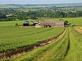
 Farm in the Vale of Pewsey - geograph.org.uk - 3357430.jpg 4,318 × 2,766; 3.99 MB
-

-
-
 Farm track at New Town - geograph.org.uk - 1912917.jpg 640 × 480; 93 KB
-
 Farm track viewed from Knap Hill - geograph.org.uk - 2159543.jpg 1,920 × 1,280; 1.06 MB
-
 Farmland below Walkers Hill - geograph.org.uk - 6257259.jpg 2,592 × 1,944; 1.82 MB
-
 Farmland Near Alton Barnes - geograph.org.uk - 6002079.jpg 1,600 × 1,200; 512 KB
-
 Farmland, New Town Farm - geograph.org.uk - 6327688.jpg 800 × 600; 104 KB
-
 Female Common Yellow Dung Fly - geograph.org.uk - 2329241.jpg 2,371 × 1,778; 2.43 MB
-
 Field corner north of Draycott Hill - geograph.org.uk - 1915967.jpg 640 × 426; 88 KB
-
 Field corner north of Draycott Hill - geograph.org.uk - 1915975.jpg 640 × 426; 88 KB
-

-
 Field edge path - geograph.org.uk - 4497501.jpg 4,320 × 3,240; 4.78 MB
-
 Field south of Shaw Copse - geograph.org.uk - 1915991.jpg 640 × 426; 98 KB
-
 Fields by Alton Road - geograph.org.uk - 5526654.jpg 4,000 × 3,000; 2.58 MB
-
 Finger post on Knap Hill - geograph.org.uk - 1912968.jpg 640 × 486; 104 KB
-
 Follow the field edge - geograph.org.uk - 4497568.jpg 4,320 × 3,240; 4.89 MB
-

-
 Footpath, Alton Barnes - geograph.org.uk - 1428721.jpg 640 × 481; 168 KB
-
 Former parish church - geograph.org.uk - 5669065.jpg 4,320 × 3,240; 2.7 MB
-
 Former pond - geograph.org.uk - 1915933.jpg 640 × 426; 121 KB
-
 From Alton Valley bridge looking East - geograph.org.uk - 3332818.jpg 4,972 × 3,756; 6.09 MB
-
 From Knap Hill to Adam's Grave - geograph.org.uk - 5432457.jpg 4,320 × 3,240; 4.3 MB
-
 Gate and path at Knap Hill - geograph.org.uk - 4346877.jpg 640 × 427; 73 KB
-

-
 Gateway in the middle of a field - geograph.org.uk - 1915908.jpg 640 × 426; 89 KB
-
 Germander Speedwell on the Pewsey Downs - geograph.org.uk - 2381084.jpg 1,920 × 1,280; 796 KB
-
 Golden Ball Hill - geograph.org.uk - 1912264.jpg 640 × 426; 87 KB
-
 Golden Ball Hill - geograph.org.uk - 1914223.jpg 640 × 426; 98 KB
-
 Grassland north of Draycott Hill - geograph.org.uk - 1912309.jpg 640 × 431; 95 KB
-
 Grassland north of Draycott Hill - geograph.org.uk - 1915942.jpg 640 × 426; 95 KB
-
 Grassland north of Draycott Hill - geograph.org.uk - 1915982.jpg 640 × 426; 66 KB
-
 Hawthorn tree on Knap Hill - geograph.org.uk - 2160129.jpg 1,920 × 1,280; 1.95 MB
-
 Honey Street - geograph.org.uk - 3123813.jpg 640 × 480; 85 KB
-
 Honey Street bridge (no 124) - geograph.org.uk - 3704142.jpg 1,024 × 768; 136 KB
-
 Honey Street Farm (1) - geograph.org.uk - 4497550.jpg 4,320 × 3,240; 4.79 MB
-
 Honey Street Farm (2) - geograph.org.uk - 4497565.jpg 4,320 × 3,240; 4.66 MB
-
 Honeystreet - Bridge Over The Canal - geograph.org.uk - 2831036.jpg 800 × 600; 154 KB
-
 Honeystreet - Cruiser - geograph.org.uk - 2831133.jpg 800 × 600; 173 KB
-
 Honeystreet - Defended Bridge - geograph.org.uk - 2833898.jpg 800 × 600; 194 KB
-
 Honeystreet - Defended Bridge - geograph.org.uk - 2833912.jpg 800 × 600; 180 KB
-
 Honeystreet - geograph.org.uk - 3646.jpg 640 × 480; 59 KB
-
 Honeystreet - Kennet And Avon Canal - geograph.org.uk - 2831052.jpg 800 × 600; 155 KB
-
 Honeystreet - Kennet And Avon Canal - geograph.org.uk - 2831077.jpg 800 × 600; 187 KB
-
 Honeystreet - Kennet And Avon Canal - geograph.org.uk - 2831110.jpg 800 × 600; 170 KB
-
 Honeystreet - Memorial - geograph.org.uk - 2827551.jpg 800 × 600; 290 KB
-
 Honeystreet - Memorial - geograph.org.uk - 2827573.jpg 800 × 600; 169 KB
-
 Honeystreet - Narrowboats - geograph.org.uk - 2831085.jpg 800 × 600; 155 KB
-
 Honeystreet - Pillbox - geograph.org.uk - 2833933.jpg 800 × 600; 240 KB
-
 Honeystreet - Pillbox - geograph.org.uk - 2833988.jpg 800 × 600; 307 KB
-
 Honeystreet - Pillbox - geograph.org.uk - 2834004.jpg 800 × 600; 236 KB
-
 Honeystreet Bridge - geograph.org.uk - 505029.jpg 480 × 640; 502 KB
-
 Honeystreet Bridge - No.124 - KandA Canal - geograph.org.uk - 470232.jpg 640 × 493; 107 KB
-

-
 Horse and cow - geograph.org.uk - 6190719.jpg 1,024 × 678; 1.18 MB
-
 House in Honeystreet - geograph.org.uk - 6327802.jpg 800 × 554; 153 KB
-
 Houses at Alton Barnes - geograph.org.uk - 2066995.jpg 640 × 480; 94 KB
-
 Inside All Saints, Alton Priors (A) - geograph.org.uk - 4288752.jpg 480 × 640; 39 KB
-
 Inside All Saints, Alton Priors (B) - geograph.org.uk - 4288754.jpg 640 × 457; 48 KB
-
 Inside All Saints, Alton Priors (C) - geograph.org.uk - 4288755.jpg 473 × 640; 41 KB
-
 Inside All Saints, Alton Priors (D) - geograph.org.uk - 4288756.jpg 480 × 640; 39 KB
-
 Inside All Saints, Alton Priors (E) - geograph.org.uk - 4288758.jpg 640 × 471; 28 KB
-
 Inside All Saints, Alton Priors (F) - geograph.org.uk - 4288759.jpg 640 × 480; 47 KB
-
 Inside All Saints, Alton Priors (G) - geograph.org.uk - 4288760.jpg 640 × 480; 61 KB
-
 Inside All Saints, Alton Priors (H) - geograph.org.uk - 4288761.jpg 469 × 640; 36 KB
-
 Inside All Saints, Alton Priors (I) - geograph.org.uk - 4288763.jpg 476 × 640; 37 KB
-
 Inside All Saints, Alton Priors (J) - geograph.org.uk - 4288764.jpg 640 × 471; 30 KB
-
 Inside All Saints, Alton Priors (K) - geograph.org.uk - 4288765.jpg 640 × 537; 45 KB
-
 Inside St. Mary, Alton Barnes (1) - geograph.org.uk - 4288814.jpg 480 × 640; 50 KB
-
 Inside St. Mary, Alton Barnes (10) - geograph.org.uk - 4288872.jpg 640 × 480; 55 KB
-
 Inside St. Mary, Alton Barnes (2) - geograph.org.uk - 4288815.jpg 640 × 480; 52 KB
-
 Inside St. Mary, Alton Barnes (3) - geograph.org.uk - 4288817.jpg 640 × 480; 56 KB
-
 Inside St. Mary, Alton Barnes (4) - geograph.org.uk - 4288818.jpg 640 × 480; 58 KB
-
 Inside St. Mary, Alton Barnes (5) - geograph.org.uk - 4288867.jpg 640 × 480; 58 KB
-
 Inside St. Mary, Alton Barnes (6) - geograph.org.uk - 4288868.jpg 480 × 640; 39 KB
-
 Inside St. Mary, Alton Barnes (7) - geograph.org.uk - 4288869.jpg 640 × 480; 49 KB
-
 Inside St. Mary, Alton Barnes (8) - geograph.org.uk - 4288870.jpg 640 × 480; 59 KB
-
 Inside St. Mary, Alton Barnes (9) - geograph.org.uk - 4288871.jpg 640 × 480; 50 KB
-
 Just after dawn over the Vale of Pewsey - geograph.org.uk - 3658931.jpg 1,200 × 710; 257 KB
-
 Kennet and Avon Canal at Honeystreet - geograph.org.uk - 4346873.jpg 640 × 427; 104 KB
-
 Kennet and Avon Canal south of Honeystreet - geograph.org.uk - 3142885.jpg 1,843 × 1,382; 689 KB


_-_geograph.org.uk_-_4288726.jpg)
_-_geograph.org.uk_-_4288727.jpg)
_-_geograph.org.uk_-_4288728.jpg)
_-_geograph.org.uk_-_4288729.jpg)
_-_geograph.org.uk_-_4288736.jpg)
_-_geograph.org.uk_-_4288731.jpg)
_-_geograph.org.uk_-_4288732.jpg)
_-_geograph.org.uk_-_4288734.jpg)
_-_geograph.org.uk_-_4288735.jpg)
_-_geograph.org.uk_-_4288738.jpg)
_-_geograph.org.uk_-_4288741.jpg)
_-_geograph.org.uk_-_4288742.jpg)


_-_geograph.org.uk_-_4288766.jpg)
_-_geograph.org.uk_-_4288776.jpg)
_-_geograph.org.uk_-_4288767.jpg)
_-_geograph.org.uk_-_4288768.jpg)
_-_geograph.org.uk_-_4288769.jpg)
_-_geograph.org.uk_-_4288770.jpg)
_-_geograph.org.uk_-_4288771.jpg)
_-_geograph.org.uk_-_4288772.jpg)
_-_geograph.org.uk_-_4288773.jpg)
_-_geograph.org.uk_-_4288775.jpg)
_-_geograph.org.uk_-_4288722.jpg)
_-_geograph.org.uk_-_4288723.jpg)
_-_geograph.org.uk_-_4288725.jpg)
_-_geograph.org.uk_-_4288747.jpg)
_-_geograph.org.uk_-_4288749.jpg)


_-_geograph.org.uk_-_3142833.jpg)


_-_geograph.org.uk_-_5669036.jpg)
_-_geograph.org.uk_-_5669039.jpg)
_-_geograph.org.uk_-_5669041.jpg)
_-_geograph.org.uk_-_3704150.jpg)


.jpg)


.jpg)
.jpg)


_off_National_Cycle_Route_45_-_geograph.org.uk_-_6327682.jpg)


_-_geograph.org.uk_-_3704142.jpg)
_-_geograph.org.uk_-_4497550.jpg)
_-_geograph.org.uk_-_4497565.jpg)


_-_geograph.org.uk_-_4288752.jpg)
_-_geograph.org.uk_-_4288754.jpg)
_-_geograph.org.uk_-_4288755.jpg)
_-_geograph.org.uk_-_4288756.jpg)
_-_geograph.org.uk_-_4288758.jpg)
_-_geograph.org.uk_-_4288759.jpg)
_-_geograph.org.uk_-_4288760.jpg)
_-_geograph.org.uk_-_4288761.jpg)
_-_geograph.org.uk_-_4288763.jpg)
_-_geograph.org.uk_-_4288764.jpg)
_-_geograph.org.uk_-_4288765.jpg)
_-_geograph.org.uk_-_4288814.jpg)
_-_geograph.org.uk_-_4288872.jpg)
_-_geograph.org.uk_-_4288815.jpg)
_-_geograph.org.uk_-_4288817.jpg)
_-_geograph.org.uk_-_4288818.jpg)
_-_geograph.org.uk_-_4288867.jpg)
_-_geograph.org.uk_-_4288868.jpg)
_-_geograph.org.uk_-_4288869.jpg)
_-_geograph.org.uk_-_4288870.jpg)
_-_geograph.org.uk_-_4288871.jpg)


