Category:Am Sande (Lüneburg)
| Object location | | View all coordinates using: OpenStreetMap |
|---|

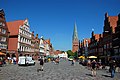
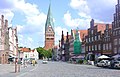
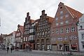
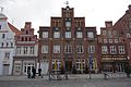
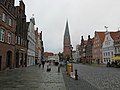
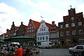
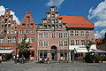
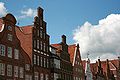
Am Sandeis a street in Lüneburg, District Lüneburg, Lower Saxony, Germany.
House numbers of the architectural monuments: 1, 2, 3, 4, 6/7, 8, 9, 10, 11, 12, 14/15, 16, 18, 19, 20, 21, 22, 23, 24, 25, 26, 25/27 a, 28, 29, 30, 30 a, 31, 31 a/b, 31 c/f, 31 g, 32, 33, 35, 36, 37, 38/39, 40, 41, 42, 43/43 a, 44, 45, 46, 47, 49, 50, 51, 52, 53, 54
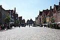
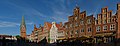
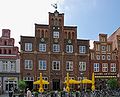
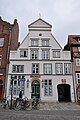
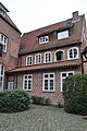
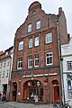
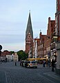
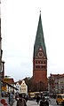
- The square Am Sande is the largest square in the city of Lüneburg. Here crossed important roads of the Middle Ages. At the beginning the square was not fortified, hence the name Am Sande. On the square are houses all architectural styles of Lüneburg. The square is characterised by the houses Am Sande 1 and 2 on the west side and the St. Johannis Church in the east of the square. Also in the east of the square is a road from the north, which also bears the name Am Sande to the next intersection (Papenstraße).
Central Square in Lüneburg .jpg) | |||||
| Upload media | |||||
| Instance of | |||||
|---|---|---|---|---|---|
| Location | Lüneburg, Lower Saxony, Germany | ||||
 | |||||
Subcategories
This category has the following 10 subcategories, out of 10 total.
A
- Am Sande 9 (14 F)
- Am Sande 31 (8 F)
- Am Sande 36 (10 F)
- Am Sande 46 (Lüneburg) (5 F)
- Am Sande 49 (Lüneburg) (2 F)
- Am Sande 53 (12 F)
B
- Bäckerei Am Sande (5 F)
E
- Einhorn-Apotheke Lüneburg (15 F)
I
L
- Landeszeitung Lüneburg (9 F)
Media in category "Am Sande (Lüneburg)"
The following 200 files are in this category, out of 221 total.
(previous page) (next page)-
 Lueneburg 2010 016.jpg 2,048 × 1,536; 1.31 MB
-
 Haus in Lüneburg skillshare 2010 Apostoloff 033.JPG 4,272 × 2,848; 7.5 MB
-
 Haus in Lüneburg skillshare 2010 Apostoloff 032.JPG 4,272 × 2,848; 1.64 MB
-
 Am Sande 45 Lüneburg.jpg 6,016 × 4,000; 2.56 MB
-
 Am Sande 43 43a 2015 Lüneburg.jpg 6,016 × 4,000; 2.56 MB
-
 Am Sande 43 43a Lüneburg.jpg 6,016 × 4,000; 2.18 MB
-
 Haus in Lüneburg skillshare 2010 Apostoloff 046.JPG 3,873 × 2,583; 1.37 MB
-
 Haus in Lüneburg skillshare 2010 Apostoloff 043.JPG 4,272 × 2,848; 5.39 MB
-
 Am Sande 27 Lüneburg.jpg 6,016 × 4,000; 1.91 MB
-
 Am Sande 29 Lüneburg.jpg 6,016 × 4,000; 1.94 MB
-
 2010-06-04-lueneburg-by-RalfR-14.jpg 3,008 × 2,000; 2.81 MB
-
 Am Sande,Lueneburg.jpg 960 × 720; 83 KB
-
 AmSande.jpg 650 × 418; 53 KB
-
 Kirche St Johannis Lueneburg.jpg 2,000 × 1,500; 1.28 MB
-
 Am Sande - panoramio.jpg 2,272 × 1,704; 923 KB
-
 Am Sande 22 - 25, Lüneburg.jpg 3,000 × 3,600; 8.66 MB
-
 050907 Lueneburg 2.jpg 1,592 × 1,200; 1.13 MB
-
 Hans von Bartels Am Sande.jpg 2,838 × 4,013; 7 MB
-
 Haus in Lüneburg skillshare 2010 Apostoloff 022.JPG 2,848 × 4,272; 6.03 MB
-
 Am Sande 12 -18 Lüneburg.jpg 6,016 × 4,000; 2.35 MB
-
 Haus in Lüneburg skillshare 2010 Apostoloff 021.JPG 2,848 × 4,272; 4.76 MB
-
 Am Sande 9 Lüneburg.jpg 6,016 × 4,000; 1.85 MB
-
 Haus in Lüneburg skillshare 2010 Apostoloff 044.JPG 4,059 × 2,705; 1.15 MB
-
 Haus in Lüneburg skillshare 2010 Apostoloff 045.JPG 4,272 × 2,848; 4.91 MB
-
 Am Sande Aprl 2015 Lüneburg.jpg 6,016 × 4,000; 1.78 MB
-
 Am Sande Lüneburg.jpg 3,876 × 2,676; 3.74 MB
-
 Am Sande, Lüneburg.jpg 3,960 × 2,228; 8.95 MB
-
 Haus in Lüneburg skillshare 2010 Apostoloff 030.JPG 2,848 × 4,272; 4.41 MB
-
 2010-06-05-lueneburg-by-RalfR-07.jpg 2,000 × 3,008; 2.28 MB
-
 2010-06-05-lueneburg-by-RalfR-08.jpg 2,000 × 3,008; 2.2 MB
-
 2010-06-06-lueneburg-by-RalfR-10.jpg 5,807 × 3,203; 5.46 MB
-
 2010-06-06-lueneburg-by-RalfR-11.jpg 3,008 × 2,000; 3.32 MB
-
 2010-06-06-lueneburg-by-RalfR-12.jpg 3,008 × 2,000; 3.38 MB
-
 2010-06-06-lueneburg-nachts-by-RalfR-2.jpg 3,008 × 2,000; 2.13 MB
-
 2010-06-06-lueneburg-nachts-by-RalfR-3.jpg 3,008 × 2,000; 1.85 MB
-
 2010-06-06-lueneburg-nachts-by-RalfR-4.jpg 3,008 × 2,000; 1.89 MB
-
 2010-06-06-lueneburg-nachts-by-RalfR-5.jpg 3,008 × 2,000; 2.26 MB
-
 2014 Lüneburg 18.jpg 4,975 × 3,317; 4.23 MB
-
 2014 Lüneburg 19.jpg 3,766 × 3,367; 2.7 MB
-
 Am Sande (Lüneburg).jpg 4,000 × 3,000; 2.65 MB
-
 Am Sande 30 Lüneburg.jpg 6,016 × 4,000; 1.99 MB
-
 Am Sande 31 Lüneburg.jpg 6,016 × 4,000; 1.84 MB
-
 Am Sande 33 Lüneburg.jpg 6,016 × 4,000; 1.47 MB
-
 Am Sande 34 Lüneburg.jpg 3,968 × 3,916; 1.23 MB
-
 Am Sande 35 Lüneburg.jpg 6,016 × 4,000; 1.96 MB
-
 Am Sande 37 Lüneburg.jpg 3,820 × 3,892; 1.42 MB
-
 Am Sande 38 39 Lüneburg.jpg 4,512 × 3,948; 1.3 MB
-
 Am Sande 40 Lüneburg.jpg 4,516 × 3,988; 1.38 MB
-
 Am Sande 42 ff. in Lüneburg (2017).jpg 4,800 × 3,000; 13.49 MB
-
 Am Sande 48 Lüneburg.jpg 6,016 × 4,000; 2.49 MB
-
 Am Sande 49 Lüneburg.jpg 6,016 × 4,000; 2.56 MB
-
 Am Sande 50 2015 Lüneburg.jpg 6,016 × 4,000; 2.37 MB
-
 Am Sande 50 Lüneburg.jpg 6,016 × 4,000; 2.45 MB
-
 Am Sande 51 Lüneburg.jpg 6,016 × 4,000; 2.28 MB
-
 Am Sande 52 Lüneburg.jpg 6,016 × 4,000; 2.47 MB
-
 Haus in Lüneburg skillshare 2010 Apostoloff 019.JPG 2,848 × 4,272; 4.78 MB
-
 Am Sande 6 7 8 Lüneburg.jpg 6,016 × 4,000; 1.96 MB
-
 Am Sande 7-12 (Lüneburg).jpg 4,000 × 3,000; 2.42 MB
-
 Am Sande 8, Lüneburg.jpg 1,707 × 2,560; 4.36 MB
-
 033 2015 07 12 Am Sande 8,6.jpg 2,746 × 1,820; 4.35 MB
-
 Am Sande, Lüneburg 2016a.jpg 4,032 × 3,024; 3.74 MB
-
 Am Sande, Lüneburg 2016b.jpg 4,032 × 3,024; 3.3 MB
-
 Am Sande, Lüneburg 2016c.jpg 4,032 × 3,024; 3.21 MB
-
 Am Sande, Lüneburg 2016d.jpg 3,024 × 4,032; 3.74 MB
-
 AmSandeLueneburg-msu-2023-0I9A-2976-.jpg 5,471 × 3,647; 5.34 MB
-
 Franz Krüger Diele Am Sande 8.jpg 4,287 × 1,475; 2.86 MB
-
 Giebelhäuser Lüneburg.jpg 1,560 × 1,151; 492 KB
-
 Haus in Lüneburg skillshare 2010 Apostoloff 020.JPG 2,848 × 4,272; 4.72 MB
-
 Haus in Lüneburg skillshare 2010 Apostoloff 029.JPG 2,848 × 4,272; 5.86 MB
-
 Haus in Lüneburg skillshare 2010 Apostoloff 031.JPG 2,848 × 4,272; 4.31 MB
-
 Haus in Lüneburg skillshare 2010 Apostoloff 034.JPG 4,272 × 2,848; 5.8 MB
-
 Haus in Lüneburg skillshare 2010 Apostoloff 035.JPG 2,848 × 4,272; 4.94 MB
-
 Haus in Lüneburg skillshare 2010 Apostoloff 036.JPG 2,848 × 4,272; 5.21 MB
-
 Haus in Lüneburg skillshare 2010 Apostoloff 038.JPG 2,848 × 4,272; 7.21 MB
-
 Haus in Lüneburg skillshare 2010 Apostoloff 039.JPG 2,848 × 4,272; 6.71 MB
-
 Haus in Lüneburg skillshare 2010 Apostoloff 040.JPG 2,848 × 4,272; 6.15 MB
-
 Haus in Lüneburg skillshare 2010 Apostoloff 041.JPG 2,848 × 4,272; 7.25 MB
-
 Haus in Lüneburg skillshare 2010 Apostoloff 042.JPG 2,848 × 4,272; 5.49 MB
-
 Im Sande stitched 2 Skillshare Apostoloff.jpg 6,054 × 2,222; 2.73 MB
-
 Im Sande stitched 3 Skillshare Apostoloff.jpg 8,928 × 2,938; 13.46 MB
-
 Industrie und Handelskammer - panoramio.jpg 2,838 × 2,129; 1.6 MB
-
 Kurt Hielscher Deutschland 1924 Lüneburg Am Sande.jpg 951 × 1,673; 545 KB
-
 Lueneburg 2010 024.jpg 2,048 × 1,536; 1.31 MB
-
 Lueneburg am sande panorama.jpg 7,496 × 2,696; 15.22 MB
-
 Lueneburg IMGP9202 wp.jpg 2,778 × 4,230; 8.18 MB
-
 Lueneburg IMGP9338 wp.jpg 2,742 × 3,522; 6.09 MB
-
 Lueneburg IMGP9343 wp.jpg 2,644 × 3,958; 6.48 MB
-
 Lueneburg IMGP9366 wp.jpg 2,038 × 3,000; 3.85 MB
-
 Lueneburg IMGP9798 wp.jpg 1,942 × 3,000; 4.13 MB
-
 Lueneburg IMGP9802 wp.jpg 3,000 × 2,022; 4.19 MB
-
 Lueneburg IMGP9804 wp.jpg 1,907 × 3,000; 3.72 MB
-
 Lueneburg IMGP9813 wp.jpg 1,949 × 3,000; 4.06 MB
-
 Lueneburg IMGP9822 wp.jpg 1,999 × 3,000; 3.96 MB
-
 Lueneburg IMGP9825 wp.jpg 2,000 × 3,000; 4.29 MB
-
 Lueneburg platz am sande ds 08 2007.jpg 1,633 × 1,250; 333 KB
-
 Lueneburg-Sand.jpg 15,808 × 6,101; 10.55 MB
-
 Luneburg, Germany (8001288882).jpg 3,888 × 2,592; 7.98 MB
-
 Luneburg, Germany (8001294107).jpg 3,888 × 2,592; 9.53 MB
-
 Luneburgo en invierno.JPG 2,560 × 1,920; 1.08 MB
-
 Lunenburg (28694172515).jpg 4,032 × 3,024; 3.96 MB
-
 Lüneburg (25809711568).jpg 5,120 × 3,840; 6.12 MB
-
 Lüneburg (25809712478).jpg 5,120 × 3,840; 6.45 MB
-
 Lüneburg (25809739878).jpg 5,120 × 3,840; 6.78 MB
-
 Lüneburg (25809740818).jpg 5,120 × 3,840; 6.63 MB
-
 Lüneburg (27903165909).jpg 5,120 × 3,840; 6.72 MB
-
 Lüneburg (38972761834).jpg 5,120 × 3,840; 6.71 MB
-
 Lüneburg (38972762594).jpg 5,120 × 3,840; 6.05 MB
-
 Lüneburg (39681515431).jpg 5,120 × 3,840; 5.55 MB
-
 Lüneburg (39681516081).jpg 5,120 × 3,840; 5.93 MB
-
 Lüneburg (39681517011).jpg 5,120 × 3,840; 6.57 MB
-
 Lüneburg (DerHexer) 02.jpg 4,288 × 2,848; 6.56 MB
-
 Lüneburg - Am Berge 05 ies.jpg 3,888 × 2,592; 1.2 MB
-
 Lüneburg - Am Sande (Wasserturm) 01 ies.jpg 3,888 × 2,592; 2.54 MB
-
 Lüneburg - Am Sande 01 ies.jpg 3,888 × 2,592; 2.11 MB
-
 Lüneburg - Am Sande 02 ies.jpg 3,888 × 2,592; 2.34 MB
-
 Lüneburg - Am Sande 03 ies.jpg 3,888 × 2,592; 1.88 MB
-
 Lüneburg - Am Sande 04 ies.jpg 3,888 × 2,592; 1.61 MB
-
 Lüneburg - Am Sande 06 ies.jpg 3,882 × 2,592; 1.63 MB
-
 Lüneburg - Am Sande 08 ies.jpg 3,882 × 2,592; 2.26 MB
-
 Lüneburg - Am Sande 10 ies.jpg 3,888 × 2,592; 2.25 MB
-
 Lüneburg - Am Sande 11 ies.jpg 3,888 × 2,592; 2.74 MB
-
 Lüneburg - Am Sande 13 ies.jpg 3,888 × 2,592; 2.81 MB
-
 Lüneburg - Am Sande 14 ies.jpg 3,888 × 2,592; 2.11 MB
-
 Lüneburg - Am Sande 15 ies.jpg 3,888 × 2,592; 1.73 MB
-
 Lüneburg - Am Sande 16 ies.jpg 3,888 × 2,592; 1.8 MB
-
 Lüneburg - Am Sande 17 ies.jpg 3,888 × 2,592; 2.16 MB
-
 Lüneburg - Am Sande 18 ies.jpg 3,888 × 2,592; 1.49 MB
-
 Lüneburg - Am Sande 19 ies.jpg 3,888 × 2,592; 1.95 MB
-
 Lüneburg - Am Sande 20 ies.jpg 3,882 × 2,592; 2.69 MB
-
 Lüneburg - Am Sande 21 ies.jpg 3,888 × 2,592; 2.1 MB
-
 Lüneburg - Am Sande 22 ies.jpg 3,888 × 2,592; 2.1 MB
-
 Lüneburg - Am Sande, Panorama.jpg 1,920 × 1,423; 2.19 MB
-
 Lüneburg 115 Am Sande 49.jpg 2,013 × 2,362; 941 KB
-
 Lüneburg 127 Am Sande 49 Giebel.jpg 1,637 × 1,634; 945 KB
-
 Lüneburg 128 Am Sande 8 Haustür.jpg 1,576 × 2,113; 708 KB
-
 Lüneburg 189 Dacherker Am Sande 40.jpg 967 × 1,302; 500 KB
-
 Lüneburg 190 Dacherker Am Sande 41.jpg 931 × 1,284; 462 KB
-
 Lüneburg 204 Brunnenbecken am Sande.jpg 1,241 × 1,500; 363 KB
-
 Lüneburg Am Sande 001 9205 BW.jpg 2,862 × 3,452; 1.11 MB
-
 Lüneburg Am Sande 001 9205.jpg 2,862 × 3,452; 1.15 MB
-
 Lüneburg Am Sande 002 9225.jpg 2,568 × 3,378; 1.18 MB
-
 Lüneburg Am Sande 003 9237.jpg 2,798 × 3,102; 1.34 MB
-
 Lüneburg Am Sande 004 9242.jpg 3,099 × 3,180; 1.27 MB
-
 Lüneburg Am Sande 005 9247.jpg 2,898 × 3,396; 1.15 MB
-
 Lüneburg Am Sande 006 9252.jpg 1,465 × 2,879; 553 KB
-
 Lüneburg Am Sande 007 9257.jpg 3,759 × 3,023; 1.5 MB
-
 Lüneburg Am Sande 008 9267.jpg 1,603 × 2,751; 753 KB
-
 Lüneburg Am Sande 012 9319.jpg 4,465 × 2,459; 2.11 MB
-
 Lüneburg Am Sande 04.jpg 2,848 × 4,288; 5.81 MB
-
 Lüneburg Am Sande 16 Hofflügel.jpg 2,848 × 4,288; 6.24 MB
-
 Lüneburg Am Sande 16.jpg 2,848 × 4,288; 6.37 MB
-
 Lüneburg Am Sande 18 Rück.jpg 2,848 × 4,288; 6.52 MB
-
 Lüneburg Am Sande 19 Hofflügel.jpg 2,848 × 4,288; 6.32 MB
-
 Lüneburg Am Sande 19.jpg 2,848 × 4,288; 6.57 MB
-
 Lüneburg Am Sande 20.jpg 2,848 × 4,288; 5.66 MB
-
 Lüneburg Am Sande 21.jpg 2,848 × 4,288; 5.85 MB
-
 Lüneburg Am Sande 23.jpg 2,848 × 4,288; 5.03 MB
-
 Lüneburg Am Sande 24.jpg 2,848 × 4,288; 4.77 MB
-
 Lüneburg Am Sande 25.jpg 2,848 × 4,288; 4.54 MB
-
 Lüneburg Am Sande 26.jpg 2,848 × 4,288; 4.42 MB
-
 Lüneburg Am Sande 28.jpg 2,848 × 4,288; 4.7 MB
-
 Lüneburg Am Sande 29 Hofflügel.jpg 2,848 × 4,288; 4.91 MB
-
 Lüneburg Am Sande 30a.jpg 2,848 × 4,288; 6.71 MB
-
 Lüneburg Am Sande 30b.jpg 2,848 × 4,288; 6.75 MB
-
 Lüneburg Am Sande 31.jpg 2,848 × 4,288; 4.56 MB
-
 Lüneburg Am Sande 31a 1.jpg 2,848 × 4,288; 6.09 MB
-
 Lüneburg Am Sande 31a.jpg 2,848 × 4,288; 5.84 MB
-
 Lüneburg Am Sande 31b.jpg 2,848 × 4,288; 6.23 MB
-
 Lüneburg Am Sande 31c.jpg 2,848 × 4,288; 6.4 MB
-
 Lüneburg Am Sande 31d.jpg 2,848 × 4,288; 5.73 MB
-
 Lüneburg Am Sande 31e.jpg 2,848 × 4,288; 6.51 MB
-
 Lüneburg Am Sande 31f.jpg 2,848 × 4,288; 7.01 MB
-
 Lüneburg Am Sande 31g.jpg 2,848 × 4,288; 6.21 MB
-
 Lüneburg Am Sande 32.jpg 2,848 × 4,288; 5.64 MB
-
 Lüneburg Am Sande 41.jpg 2,848 × 4,288; 4.49 MB
-
 Lüneburg Am Sande 42.jpg 2,848 × 4,288; 5.02 MB
-
 Lüneburg Am Sande 43.jpg 2,848 × 4,288; 5.55 MB
-
 Lüneburg Am Sande 45.jpg 2,848 × 4,288; 6.19 MB
-
 Lüneburg Am Sande 47.jpg 2,848 × 4,288; 5.44 MB
-
 Lüneburg Am Sande 52 Hofflügel.jpg 2,848 × 4,288; 6.38 MB
-
 Lüneburg Am Sande 52 Wirtschaftsgebäude.jpg 2,848 × 4,288; 5.77 MB
-
 Lüneburg Am Sande 52.jpg 2,848 × 4,288; 4.42 MB
-
 Lüneburg Am Sande abends.jpg 2,354 × 3,240; 2.05 MB
-
 Lüneburg Am Sande mit St. Johannis.jpg 3,648 × 2,736; 2.58 MB
-
 Lüneburg am Sande Ostseite.jpg 1,600 × 1,200; 1.37 MB
-
 Lüneburg Am Sande vom Wasserturm 2.jpg 3,110 × 2,206; 3.05 MB
-
 Lüneburg Am Sande vom Wasserturm.jpg 3,264 × 2,448; 2.47 MB
-
 Lüneburg Am Sande47 Relief.jpg 2,448 × 3,264; 2.53 MB
-
 Lüneburg Am Sande47.jpg 2,014 × 3,220; 2.23 MB
-
 Lüneburg Plan 1889 Am Sande.jpg 1,243 × 767; 630 KB
-
 Lüneburg St Johannis.jpg 2,796 × 3,131; 1.03 MB
-
 Lüneburg, der Platz "Am Sande", Turm der Kirche St. Johannis.jpg 1,531 × 2,558; 668 KB
-
 Lüneburg, der Platz "Am Sande".jpg 2,335 × 1,699; 1.57 MB
-
 Lüneburg, die Häuser Am Sande 1 und 3.jpg 2,232 × 1,674; 1.28 MB
-
 Lüneburg, Haus Am Sande 3.jpg 656 × 1,074; 376 KB
-
 Lüneburg, Häuserzeile am Platz "Am Sande".jpg 2,300 × 1,644; 1.29 MB
-
 Lüneburg, Innenstadt, Restaurantmeile.JPG 3,680 × 2,760; 3.77 MB
-
 Lüneburg, Niedersachsen - Schütting; Am Sande; Stintmarkt (Zeno Ansichtskarten).jpg 1,374 × 2,181; 266 KB
-
 Lüneburg, the square "Am Sande".jpg 2,462 × 1,387; 948 KB
-
 Lüneburg-amsande01.jpg 2,304 × 1,728; 2.62 MB


.jpg)


.jpg)


.jpg)
.jpg)

.jpg)
.jpg)
.jpg)
.jpg)
.jpg)
.jpg)
.jpg)
.jpg)
.jpg)
.jpg)
.jpg)
_02.jpg)

_01_ies.jpg)


.jpg)


&filefrom=L%C3%BCneburg-amsande02.jpg#mw-category-media)