Category:Ammergauer Alpen

mountain range   | |||||
| Upload media | |||||
| Instance of | |||||
|---|---|---|---|---|---|
| Made from material | |||||
| Located in protected area | |||||
| Location | |||||
| Mountain range | |||||
| Highest point | |||||
| Elevation above sea level |
| ||||
 | |||||
Deutsch: Ammergauer Alpen oder Ammergebirge.
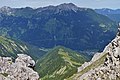
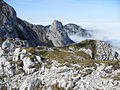
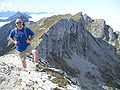
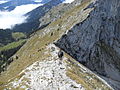
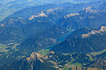
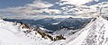
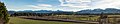
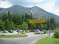
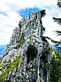
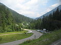
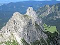
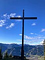
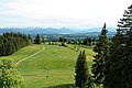
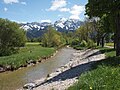
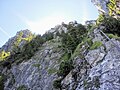
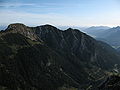
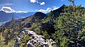
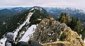
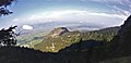
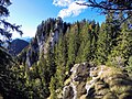
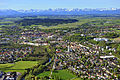
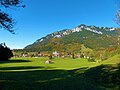
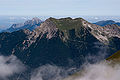
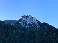
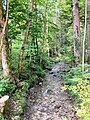
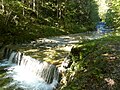
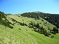
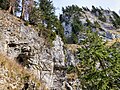
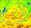
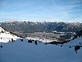
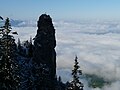
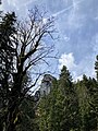
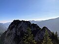
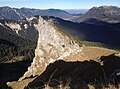
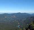
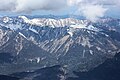
English: The Ammergau Alps are a mountain range in the Northern Limestone Alps in the states of Bavaria (Germany) and Tyrol (Austria). They cover an area of about 30 x 30 km and begin at the outer edge of the Alps. The highest summit is the Daniel which has a height of 2,340 m.
Deutsch: Als Abgrenzung für die Region wird die Definition der Nördlichen Kalkalpen und ihrer Unterteilung in einzelne Gebirgsgruppen nach Alpenvereinseinteilung der Ostalpen (AVE) verwendet.[1].
Subcategories
This category has the following 25 subcategories, out of 25 total.
A
B
- Brunnenkopf (Berg) (1 F)
E
F
G
- Großer Zunderkopf (1 F)
H
- Hirschbichel (1 F)
K
- Kohlbergspitze (14 F)
- Kolbensattel (4 F)
L
- Laubeneck (1 F)
- Lobentalbach (5 F)
N
- Neidernach (Loisach) (13 F)
R
- Rappenkopf (Ammergau) (2 F)
S
- Schleifmühlenlaine (22 F)
T
- Torsäulenbach (3 F)
V
- Views to the Ammergauer Alpen (29 F)
- Vorderer Felderkopf (2 F)
Z
Pages in category "Ammergauer Alpen"
This category contains only the following page.
Media in category "Ammergauer Alpen"
The following 142 files are in this category, out of 142 total.
-
 09-Gipsmühle.jpg 2,030 × 1,512; 1.52 MB
-
 14-Grubigstein-NO.jpg 4,240 × 2,832; 6.4 MB
-
 20090919 Hiking the Hochplatte (04).JPG 3,072 × 2,304; 1.72 MB
-
 20090919 Hiking the Hochplatte (21).JPG 3,072 × 2,304; 1.7 MB
-
 20090919 Hiking the Hochplatte (38).JPG 3,072 × 2,304; 1.78 MB
-
 20090919 Hiking the Hochplatte (47).JPG 3,072 × 2,304; 1.76 MB
-
 20090919 Hiking the Hochplatte (59).JPG 3,072 × 2,304; 1.79 MB
-
 20090919 Hiking the Hochplatte (65).JPG 3,072 × 2,304; 1.8 MB
-
 20090919 Hiking the Hochplatte (68).JPG 3,072 × 2,304; 1.79 MB
-
 2011-05-09 10-12-23 Austria Tirol Boden.jpg 4,288 × 2,848; 7.96 MB
-
 20170227 Panorama Reutte 03 DSC00914 H PtrQs.jpg 7,771 × 3,206; 19.26 MB
-
 20171122 A7 Exit138 PanoramaAlpenA7 DSC06977 tiltCCW PtrQs.JPG 20,000 × 3,972; 64.12 MB
-
 2019-06-30 Heiterwanger See Tirol 22.jpg 5,184 × 3,456; 7.76 MB
-
 Alpen-blender-text.jpg 7,500 × 537; 1.96 MB
-
 Alpen-blender.jpg 7,500 × 537; 1.82 MB
-
 Alpii Ammergau.jpg 3,072 × 2,304; 932 KB
-
 Alpii Ammergau1.jpg 3,072 × 2,304; 1.09 MB
-
 Alpii Ammergau2.jpg 3,072 × 2,304; 1.31 MB
-
 Alpii Ammergau3.jpg 3,072 × 2,304; 914 KB
-
 Alpspitze mit Blick auf das Loisachtal.jpg 3,456 × 2,304; 2.83 MB
-
 Am Zahn.jpg 3,024 × 4,032; 3.89 MB
-
 Ammersattel.jpg 3,072 × 2,304; 741 KB
-
 AmmgAlpen KraeheAhornspitze2012.jpg 1,131 × 848; 399 KB
-
 AmmgAlpen KraeheGumpenkarspitzeGeiselstein2012.jpg 1,131 × 848; 390 KB
-
 Aschauer Berg.jpg 4,032 × 3,024; 3.55 MB
-
 Aufacker-Gipfelkreuz.jpg 3,024 × 4,032; 1.2 MB
-
 Ausblick Auerberg bjs070510-03.jpg 3,456 × 2,304; 2.08 MB
-
 Berge des Außerfern - panoramio.jpg 2,000 × 1,339; 510 KB
-
 Bergpanorama vom Friederspitz, Sonnenuntergang.jpg 10,770 × 3,716; 12.58 MB
-
 Bernbeuren - Auerberg - Firstberg, Zugspitze, Schneefernerkopf 230918 - 02.jpg 4,608 × 2,167; 605 KB
-
 Blick vom Hennenkopf auf Ammergebirge und Wettersteingebirge.jpg 4,396 × 2,770; 6.64 MB
-
 Blick von der Zugspitze auf den Eibsee. 8a origWI.jpg 3,749 × 2,447; 3.14 MB
-
 Brandnerschrofen.jpg 800 × 600; 156 KB
-
 Burg Falkenstein Pfronten 5.jpg 1,600 × 1,200; 313 KB
-
 Burg Falkenstein Pfronten 6.jpg 1,600 × 1,200; 346 KB
-
 Burgstall Schaumburg GO-5.jpg 2,592 × 1,944; 1.27 MB
-
 Daniel-Upsspitze Gipfelgrat Blick nach Norden.JPG 3,264 × 2,448; 4 MB
-
 Dreisäulerkopf.jpg 3,503 × 2,054; 2.04 MB
-
 DSC02508 Füssen bei Nacht mit Tegelberg und Säuling.jpg 5,296 × 3,104; 2.68 MB
-
 Edelsberg.JPG 3,264 × 2,448; 2.94 MB
-
 Ehrwald - Ort mit dem Daniel 2340 Hm.NN.JPG 5,348 × 2,671; 2.57 MB
-
 Festung Schlosskopf 4.jpg 800 × 600; 121 KB
-
 Flug -Rom-Düsseldorf-Hamburg 2013 by-RaBoe 179.jpg 3,666 × 2,361; 1.14 MB
-
 Flug -Rom-Düsseldorf-Hamburg 2013 by-RaBoe 180.jpg 3,666 × 2,361; 1.16 MB
-
 Forggensee Muehlberger Ache.JPG 4,032 × 3,024; 2.39 MB
-
 Gehrenspitze Reutte.JPG 3,264 × 2,448; 4.68 MB
-
 Geierköpfe und Kreuzspitze.jpg 8,725 × 3,852; 5.99 MB
-
 Geiselstein Gabelschrofen.jpg 800 × 600; 165 KB
-
 GeiselsteinP.png 953 × 295; 138 KB
-
 Gelbe-Wand Klettersteig mit Gelber Wandschrofen.jpg 1,320 × 990; 717 KB
-
 Germany July 5 (9425827693).jpg 1,200 × 803; 838 KB
-
 Graflaine (Große Laine).jpg 3,024 × 4,032; 4.09 MB
-
 Grainau, Eibsee, Leihstelle für Boote, Ammergauer Alpen.JPG 4,272 × 2,848; 3.15 MB
-
 Grosse Schlicke Karretschrofen Bugschrofen.JPG 3,264 × 2,448; 2.58 MB
-
 Großer Laber.jpg 7,010 × 3,888; 8.97 MB
-
 Gämse am Frieder.jpg 1,272 × 1,148; 635 KB
-
 Günzach - Schlegelsberg Ri SO - Auerberg, H Trauchberg, Ammergeb 020120.jpg 4,443 × 1,521; 570 KB
-
 Halblech Lobenbachtal.jpg 3,424 × 1,168; 3.27 MB
-
 Hennenkopf.jpg 3,465 × 1,870; 2.05 MB
-
 Herrsching Ammersee , liegende Weide (8353092575).jpg 4,907 × 3,259; 8.35 MB
-
 Hiking the Hochplatte (Ammergauer Alpen).jpg 3,072 × 2,304; 1.74 MB
-
 Hohenpeißenberg - H Peißenberg - Rottenbuch - Schönberg v N, Kreuzspitz 140221.jpg 4,608 × 2,592; 925 KB
-
 Hopferau BAB 7 GO.jpg 2,592 × 1,944; 1 MB
-
 Hornburg (Ammergebirge).jpg 3,949 × 1,903; 1.43 MB
-
 Hornburg Schwangau.jpg 4,032 × 1,960; 3.24 MB
-
 Höllstein.jpg 4,000 × 3,000; 4.38 MB
-
 Hütte unterm Lichtbrenntjoch - panoramio.jpg 2,000 × 1,339; 435 KB
-
 ISS030-E-17138 - View of Germany.jpg 4,288 × 2,848; 2.02 MB
-
 ISS058-E-13135 - View of Earth.jpg 3,712 × 5,568; 3.13 MB
-
 Karretschrofen02.JPG 3,264 × 2,448; 4.03 MB
-
 Karte Ammergauer Alpen.png 3,721 × 3,458; 2.54 MB
-
 Kaufbeuren Luftbild 01.jpg 4,520 × 3,020; 5.23 MB
-
 Kenzenbach.JPG 2,033 × 1,692; 1.59 MB
-
 Kienjoch.jpg 2,048 × 1,536; 1,018 KB
-
 Kleine Ammer im Ettaler Weidmoos im oberen Ammertal.jpg 3,264 × 4,928; 8.06 MB
-
 Kleiner Laber.jpg 1,210 × 1,613; 1.31 MB
-
 Klettersteig Riffelscharte.jpeg 5,536 × 2,160; 4.16 MB
-
 Kofel Ettal Laber.jpg 1,200 × 900; 1.4 MB
-
 Kohlbergspitze.jpg 3,888 × 2,592; 2.91 MB
-
 Krinnenspitze from Litnisschrofen.JPG 3,264 × 2,448; 3.88 MB
-
 Laberköpfl.jpg 4,032 × 3,024; 606 KB
-
 Laberlaine (Ramsach).jpg 3,024 × 4,032; 5.03 MB
-
 Lahnegraben (Lindenbach).jpg 4,032 × 3,024; 2.55 MB
-
 Lahnenwiesgraben 11.jpg 1,200 × 900; 1.77 MB
-
 Lahnenwiesgraben 12.jpg 1,200 × 900; 473 KB
-
 Lahnenwiesgraben 13.jpg 1,200 × 900; 487 KB
-
 Lahnenwiesgraben 14.jpg 1,920 × 1,080; 729 KB
-
 Lahnenwiesgraben 15.jpg 1,600 × 1,200; 871 KB
-
 Lahnenwiesgraben 18.jpg 1,600 × 1,200; 971 KB
-
 Lahnenwiesgraben 19.jpg 1,600 × 1,200; 1.05 MB
-
 Lahnenwiesgraben 21.jpg 1,600 × 1,200; 751 KB
-
 Lahnenwiesgraben 22.jpg 1,600 × 1,200; 939 KB
-
 Lengenwang - Kirche v NW, Ammergebirge 190412.JPG 2,560 × 1,440; 1.69 MB
-
 Loesertalkopf Gipfelpanorama.jpg 10,304 × 1,046; 2.89 MB
-
 Loesertalkopf.jpg 2,272 × 1,704; 2.8 MB
-
 Luftbild Alpen 05 (RaBoe).jpg 1,000 × 750; 676 KB
-
 Martinswand.jpg 4,032 × 3,024; 5.93 MB
-
 Naturpark Ammergauer Alpen.png 1,990 × 1,850; 368 KB
-
 Naturschutzgebiet Ammergauer Alpen.jpg 1,772 × 1,181; 525 KB
-
 Naturschutzgebiet Ammergebirge Säuling.jpg 8,858 × 5,912; 46.69 MB
-
 Naturschutzgebiet Ammergebirge.jpg 6,277 × 3,155; 15.8 MB
-
 Nebengipfel an der Kohlbergspitze - panoramio.jpg 2,000 × 1,339; 738 KB
-
 Niederbleick Panorama.jpg 13,651 × 936; 3.53 MB
-
 OALSchwangauWaltenhofen06.jpg 4,272 × 2,848; 1.68 MB
-
 Ostallgäu GO-1.jpg 2,592 × 1,944; 1.13 MB
-
 Panorama Morgenbach&Ammergauer Alpen.jpg 18,872 × 2,079; 3.84 MB
-
 Pfronten - Edelsberg - Weissensee, Pfronten DxO.jpg 2,272 × 1,704; 2.65 MB
-
 Plansee und die Spitze vom Heiterwanger See - panoramio (1).jpg 2,000 × 1,339; 502 KB
-
 Plansee und die Spitze vom Heiterwanger See - panoramio.jpg 2,000 × 1,339; 438 KB
-
 Reutte (Tirol).JPG 3,264 × 2,448; 3.21 MB
-
 Reutte - Plansee Ri Ammerwald - Torsäulenbach, Winter.JPG 2,272 × 1,704; 1.18 MB
-
 Riegsee (Gemeinde) GO-2.jpg 3,264 × 2,448; 2.43 MB
-
 Rossberg Forggensee.JPG 3,264 × 2,448; 3.26 MB
-
 Roter Stein.JPG 3,264 × 2,448; 2.45 MB
-
 Schartenkopf (Ammergauer Alpen).jpg 4,000 × 3,000; 3.67 MB
-
 Scheinbergspitz.JPG 1,820 × 1,473; 450 KB
-
 Scheinbergspitze.jpg 2,816 × 2,112; 1.13 MB
-
 Schwangau - Illasbergsee Halbinsel - Hochplatte, Abendrot.JPG 2,451 × 1,658; 1.19 MB
-
 Schwangau - Tegelberg - Gelber Wandschrofen v N 03.JPG 3,264 × 2,448; 3.59 MB
-
 Schwangau-3.jpg 4,864 × 3,243; 8.89 MB
-
 Schwarzenkopf.jpg 3,024 × 4,032; 3.88 MB
-
 Sefelwand-Grat.jpg 4,032 × 3,024; 1.83 MB
-
 Sefelwand.jpg 9,202 × 3,858; 8.62 MB
-
 Soiener See soir Hohe Bleick.jpg 1,276 × 732; 723 KB
-
 Spießberg.jpg 12,058 × 3,814; 6.42 MB
-
 Stamm Ägypten, Osterwanderlager 1984 - Kenzenkopf.png 1,650 × 1,070; 2.17 MB
-
 Starnberger See, HB-03.jpg 2,480 × 1,770; 3.12 MB
-
 Stuibenspitze 151103.jpg 800 × 593; 112 KB
-
 Sägertalbach.jpg 4,032 × 3,024; 5.74 MB
-
 Thaneller und Galtjoch - panoramio.jpg 2,000 × 1,339; 534 KB
-
 Trauchberge.jpg 1,080 × 963; 671 KB
-
 View from Zugspitze to Austria.jpg 8,435 × 2,537; 2.33 MB
-
 Vivir y convivir.jpg 4,000 × 3,000; 4.41 MB
-
 Wassergraben (Eschenbach).jpg 3,024 × 4,032; 5.39 MB
-
 Waxenstein von jubigrat 20120819.jpg 4,000 × 3,000; 3.84 MB
-
 Weißenbach (Halbammer).jpg 4,032 × 3,024; 4.88 MB
-
 Weißensee (Füssen).jpg 1,944 × 996; 867 KB
-
 Werners Eck - panoramio.jpg 2,000 × 1,339; 668 KB
-
 Wetzsteinkalk neu.jpg 2,000 × 1,334; 463 KB
-
 Wildeck Gsäß.jpg 4,608 × 2,592; 3.38 MB
-
 Wolkenmeer im Ammergebirge.jpg 7,981 × 3,913; 4.95 MB
-
 Zugspitze, Blick zu den Ammergauer Alpen.JPG 4,272 × 2,848; 3.38 MB


.JPG)
.JPG)
.JPG)
.JPG)
.JPG)
.JPG)
.JPG)


.jpg)
.jpg)


.jpg)
.jpg)


.jpg)


.jpg)
.jpg)


.jpg)


.jpg)

.JPG)

_GO-2.jpg)


.jpg)


.jpg)

.jpg)
.jpg)


