Category:April 2009 in Herefordshire
Deutsch: Bilder, die im April 2009 in Herefordshire aufgenommen worden sind. Bitte beachten Sie, dass dies weder das Datum des Uploads noch das Datum des Scannens eines Fotos ist.
English: Images/pictures taken in Herefordshire during April 2009. Note this is not the date of the upload, nor the date a photo was scanned.
Español: Fotografías o imágenes tomadas en Herefordshire durante abril 2009. No es la fecha de subida ni escaneo, sino la fecha en que las fotografías o imágenes se crearon.
Esperanto: Bildoj faritaj en Herefordshire en aprilo 2009. Tio ne estas la dato, kiam la bildoj estis alŝutitaj aŭ skanitaj.
Français : Photographies ou images prises en Herefordshire durant avril 2009. Ce n'est pas la date du téléchargement ou du scan.
Galego: Fotografías ou imaxes tomadas en Herefordshire durante abril 2009. Non é a data de subida nin escaneamento, senón a data na que se crearon as fotografías ou imaxes.
Italiano: Fotografie o immagini scattate a Herefordshire nel aprile 2009. Nota bene: la data non si riferisce né a quella di upload né a quella in cui la foto è stata digitalizzata.
Norsk bokmål: Bilder tatt i Herefordshire i løpet av april 2009. Merk at dette ikke er datoen for opplasting, eller når et bilde har blitt skannet.
Norsk nynorsk: Bilete teke i Herefordshire i løpet av april 2009. Merk at dette ikkje er datoen for opplasting, eller når eit bilete har vorte skanna.
Русский: Изображения, сделанные в Herefordshire в течение апрель 2009 (не дата загрузки изображения).
Українська: Зображення, зроблені в Herefordshire протягом квітень 2009. Зауважте, що це не дата завантаження чи дата сканування фотографії.
| April 2008 | ← | April 2009 | → | April 2010 | |||||||
| Jan | Feb | Mar | Apr | May | Jun | Jul | Aug | Sep | Oct | Nov | Dec |
| 144 | 111 | 158 | 173 | 64 | 180 | 61 | 133 | 63 | 66 | 43 | 53 |
|---|---|---|---|---|---|---|---|---|---|---|---|
Media in category "April 2009 in Herefordshire"
The following 173 files are in this category, out of 173 total.
-
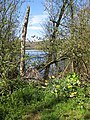 A glimpse of the lake - geograph.org.uk - 1248549.jpg 480 × 640; 234 KB
-
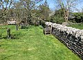 A quiet corner of a country churchyard - geograph.org.uk - 1248587.jpg 640 × 459; 179 KB
-
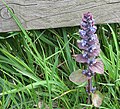 A single spear of Bugle - geograph.org.uk - 1270949.jpg 640 × 580; 288 KB
-
 A thin carpet of bluebells - geograph.org.uk - 1274342.jpg 640 × 457; 310 KB
-
 Access track to houses at Great Marston - geograph.org.uk - 1522328.jpg 640 × 480; 112 KB
-
 Approaching Hereford Station - geograph.org.uk - 1268778.jpg 640 × 465; 66 KB
-
 Arable land near Bilfield Farm - geograph.org.uk - 1515282.jpg 640 × 480; 131 KB
-
 Arable land on the Great Marston Estate - geograph.org.uk - 1522389.jpg 640 × 480; 111 KB
-

-
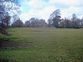
 Berrington Hall parkland - geograph.org.uk - 1274998.jpg 640 × 480; 88 KB
-
 Berrington Pool - geograph.org.uk - 1263214.jpg 640 × 426; 96 KB
-
 Berrington Pool - geograph.org.uk - 1265843.jpg 640 × 426; 95 KB
-
 Berrington Pool - geograph.org.uk - 1266944.jpg 640 × 426; 128 KB
-
 Berrington Pool - geograph.org.uk - 1266948.jpg 640 × 426; 115 KB
-
 Bilfield communications mast - geograph.org.uk - 1515274.jpg 640 × 480; 83 KB
-
 Bilfield Farm - geograph.org.uk - 1515222.jpg 640 × 480; 116 KB
-
 Bodenham's War Memorial - geograph.org.uk - 1248855.jpg 640 × 469; 108 KB
-
 Bridleway sign near Great Marston - geograph.org.uk - 1520162.jpg 640 × 480; 104 KB
-
 Brook running through Haugh Wood - geograph.org.uk - 1274322.jpg 453 × 640; 290 KB
-
 Bull rushes, Berrington Pool - geograph.org.uk - 1265848.jpg 640 × 426; 152 KB
-
 Cannocks Wood - geograph.org.uk - 1250857.jpg 640 × 480; 186 KB
-
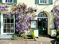 Castle Lodge entrance with wisteria - geograph.org.uk - 1274713.jpg 640 × 480; 222 KB
-
 Charcoal burner near Hatfield Court - geograph.org.uk - 1511565.jpg 640 × 480; 170 KB
-
 Chase Hill - geograph.org.uk - 1268615.jpg 640 × 480; 235 KB
-
 Chase Road - geograph.org.uk - 1231814.jpg 640 × 480; 128 KB
-
 Cherry blossom 1 - geograph.org.uk - 1251061.jpg 640 × 480; 194 KB
-
 Churchyard Steps, St. Mary's - geograph.org.uk - 1231713.jpg 480 × 640; 120 KB
-
 Corn field near The Broad - geograph.org.uk - 1289623.jpg 640 × 480; 131 KB
-
 Curvaceous - geograph.org.uk - 1231871.jpg 640 × 415; 115 KB
-
 Dandelion-rich pasture - geograph.org.uk - 1257928.jpg 480 × 640; 223 KB
-
 David's bench - geograph.org.uk - 1268558.jpg 640 × 480; 287 KB
-
 Drain from the egg production unit - geograph.org.uk - 1511540.jpg 640 × 472; 114 KB
-
 Dutch barn near Berrington Hall - geograph.org.uk - 1278994.jpg 640 × 480; 108 KB
-
 Dymock Forest in spring - geograph.org.uk - 1251112.jpg 640 × 480; 223 KB
-
 Eastfield Road - geograph.org.uk - 1231738.jpg 640 × 480; 126 KB
-
 Embankment drainage tunnel - geograph.org.uk - 1511283.jpg 480 × 640; 147 KB
-
 End Of The Road, Marston Stannett - geograph.org.uk - 1235623.jpg 640 × 480; 264 KB
-
 Entrance drive to The Homestead - geograph.org.uk - 1290868.jpg 640 × 480; 111 KB
-
 Entrance driveway to Eye church - geograph.org.uk - 1282016.jpg 640 × 480; 90 KB
-
 Entrance lane to Crossbrook Farm - geograph.org.uk - 1280305.jpg 640 × 480; 81 KB
-
 Entrance to a new egg production unit - geograph.org.uk - 1511485.jpg 640 × 480; 108 KB
-
 Entrance to Alton Business Park - geograph.org.uk - 1231821.jpg 640 × 465; 58 KB
-
 Entrance to Fairview Holiday Park - geograph.org.uk - 1511381.jpg 640 × 480; 111 KB
-
 Entrance to Fencote Station - geograph.org.uk - 1512745.jpg 640 × 469; 117 KB
-
 Entrance to Little Crows - geograph.org.uk - 1287452.jpg 640 × 480; 118 KB
-
 Eye cemetery - geograph.org.uk - 1280316.jpg 640 × 480; 98 KB
-
 Eye Church - geograph.org.uk - 1261730 (cropped).jpg 630 × 413; 75 KB
-
 Eye Church - geograph.org.uk - 1261730.jpg 640 × 426; 85 KB
-
 Eye church interior - geograph.org.uk - 1285430.jpg 640 × 480; 85 KB
-
 Eye churchyard - geograph.org.uk - 1282132.jpg 640 × 480; 129 KB
-
 Eye lych gate - geograph.org.uk - 1263027.jpg 426 × 640; 69 KB
-
 Farm track near Grendon Court - geograph.org.uk - 1516791.jpg 640 × 480; 120 KB
-
 Farmland at Little Crows - geograph.org.uk - 1287447.jpg 640 × 469; 69 KB
-
 Farmland near Quarry Coppice - geograph.org.uk - 1287503.jpg 640 × 480; 150 KB
-
 Farmland west of Grendon Court Farm - geograph.org.uk - 1516807.jpg 640 × 480; 124 KB
-
 Felled beeches and a few oaks - geograph.org.uk - 1270940.jpg 640 × 480; 218 KB
-
 Fencote Station - geograph.org.uk - 1512686.jpg 640 × 480; 143 KB
-
 Fencote Station closeup - geograph.org.uk - 1512699.jpg 640 × 480; 133 KB
-
 Fields Near Marston Stannett - geograph.org.uk - 1235614.jpg 640 × 480; 181 KB
-
 Fields Of Risbury - geograph.org.uk - 1235597.jpg 640 × 480; 211 KB
-
 Flowering stage of the bilberry plant - geograph.org.uk - 1274494.jpg 640 × 443; 251 KB
-
 Footpath in Dymock Forest - geograph.org.uk - 1251106.jpg 640 × 480; 229 KB
-
 Footpath in Dymock Forest. - geograph.org.uk - 1251118.jpg 640 × 480; 235 KB
-
-
 Footpath to Eye church - geograph.org.uk - 1280313.jpg 640 × 480; 123 KB
-

-
-

-
 Gated entrance to Merrivale Farm - geograph.org.uk - 1231780.jpg 640 × 480; 79 KB
-
 Gatley Farm outbuildings - geograph.org.uk - 1259668.jpg 640 × 480; 139 KB
-
 GPO marker - geograph.org.uk - 1231704.jpg 461 × 640; 200 KB
-
 Grazing land at Grendon Court - geograph.org.uk - 1516797.jpg 640 × 480; 133 KB
-
 Green lane at Moreton - geograph.org.uk - 1263086.jpg 640 × 426; 102 KB
-
 Green lane near Shuttocks Hill - geograph.org.uk - 1263098.jpg 426 × 640; 126 KB
-
 Green trail through Haugh Wood - geograph.org.uk - 1270868.jpg 640 × 465; 282 KB
-

-

-

-
 Grove of poplars near Great Marston - geograph.org.uk - 1520085.jpg 640 × 480; 108 KB
-
 Ha-ha at Berrington Hall - geograph.org.uk - 1263574.jpg 640 × 426; 92 KB
-
 Hatfield Court - geograph.org.uk - 1511400.jpg 640 × 480; 110 KB
-
 Hatfield Court Farm - geograph.org.uk - 1512265.jpg 640 × 483; 84 KB
-
 Hatfield village - geograph.org.uk - 1512548.jpg 640 × 480; 96 KB
-
 Hereford Garden Centre - geograph.org.uk - 1248389.jpg 640 × 480; 96 KB
-
 Herefordshire Trail west of Hatfield - geograph.org.uk - 1512570.jpg 640 × 480; 91 KB
-
 House, Evendine Lane - geograph.org.uk - 1258346.jpg 640 × 480; 69 KB
-
 Humber valley - geograph.org.uk - 1510499.jpg 640 × 480; 111 KB
-
 Ingestone - geograph.org.uk - 1253944.jpg 640 × 480; 214 KB
-
 Ingestone Only - geograph.org.uk - 1253933.jpg 480 × 640; 203 KB
-
 Interior of St Leonard's - 1 - geograph.org.uk - 1512260.jpg 640 × 480; 109 KB
-
 Interior of St Leonard's - 2 - geograph.org.uk - 1512264.jpg 640 × 480; 93 KB
-
 Junction For Marston Stannett - geograph.org.uk - 1235605.jpg 640 × 480; 227 KB
-
 Kington goods shed (geograph 4032491).jpg 3,872 × 2,592; 4.27 MB
-
 Kingtons first railway station (geograph 4032486).jpg 3,872 × 2,592; 4.51 MB
-
 Lane at Hatfield - geograph.org.uk - 1512243.jpg 640 × 480; 112 KB
-
 Lane near Hatfield Court - geograph.org.uk - 1511340.jpg 640 × 480; 105 KB
-
 Lane out of Hatfield - geograph.org.uk - 1512558.jpg 640 × 480; 97 KB
-
 Lane through Hatfield - geograph.org.uk - 1512277.jpg 640 × 480; 129 KB
-
 Lane to Eye - geograph.org.uk - 1280308.jpg 640 × 480; 93 KB
-
 Large meadow at Grendon Court Farm - geograph.org.uk - 1516802.jpg 640 × 480; 79 KB
-
 Lay-by by the A417 - geograph.org.uk - 1253901.jpg 640 × 480; 188 KB
-
 Lay-by by the A417 - geograph.org.uk - 1253904.jpg 640 × 480; 210 KB
-
 Leaning on a stile - geograph.org.uk - 1231866.jpg 640 × 439; 102 KB
-
 Leominster Canal north of Park Farm - geograph.org.uk - 1274335.jpg 480 × 640; 152 KB
-
 Looking towards Weston Hall 2 - geograph.org.uk - 1257925.jpg 640 × 480; 236 KB
-
 Main Ditch - 1 - geograph.org.uk - 1280310.jpg 640 × 480; 110 KB
-
 Main Ditch and Crossbrook Farm - geograph.org.uk - 1280311.jpg 640 × 480; 118 KB
-
 Marston Stannett - geograph.org.uk - 1235626.jpg 640 × 480; 160 KB
-
 Meadow near Hatfield Church - geograph.org.uk - 1512241.jpg 640 × 480; 109 KB
-
 Meadows in the Humber valley - geograph.org.uk - 1511307.jpg 640 × 480; 104 KB
-
 Merrivale Road - geograph.org.uk - 1231766.jpg 640 × 480; 78 KB
-
 Minor track through Haugh Wood - geograph.org.uk - 1274501.jpg 480 × 640; 325 KB
-
 Moreton Ride - geograph.org.uk - 1265852.jpg 426 × 640; 135 KB
-
 Oak tree leafing up - geograph.org.uk - 1268153.jpg 640 × 480; 223 KB
-
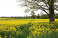
 Oil seed rape crop at Hill Farm - 2 - geograph.org.uk - 1287512.jpg 640 × 480; 153 KB
-
 Oil seed rape crop at Hill Farm - 3 - geograph.org.uk - 1287516.jpg 640 × 480; 152 KB
-
 Oil seed rape crop at Hill Farm - geograph.org.uk - 1287508.jpg 640 × 480; 124 KB
-
 Old barn by the A40 at Wilton - geograph.org.uk - 1274731.jpg 640 × 480; 211 KB
-
 Old boat house, Berrington Pool - geograph.org.uk - 1265868.jpg 640 × 426; 105 KB
-
 Old railway bridge - geograph.org.uk - 1511276.jpg 640 × 480; 165 KB
-
 Old railway embankment - geograph.org.uk - 1511272.jpg 640 × 480; 96 KB
-

-
 Potato field near Bromsash 2 - geograph.org.uk - 1237709.jpg 640 × 480; 215 KB
-
 Potato fields near Bromsash - geograph.org.uk - 1237707.jpg 480 × 640; 198 KB
-
 Public footpath in the Humber valley - geograph.org.uk - 1511319.jpg 640 × 480; 113 KB
-
 Recently planted orchard - geograph.org.uk - 1267827.jpg 640 × 480; 243 KB
-
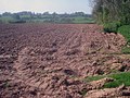
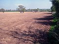
 Red soil of Ross - geograph.org.uk - 1268578.jpg 640 × 480; 203 KB
-
 Red soil of Ross 2 - geograph.org.uk - 1268584.jpg 640 × 480; 238 KB
-
 Remains of the Leominster Canal - geograph.org.uk - 1263064.jpg 640 × 426; 109 KB
-
 River Wye - geograph.org.uk - 1249700.jpg 640 × 480; 121 KB
-
 River Wye, north of Goodrich Castle - geograph.org.uk - 1250865.jpg 640 × 480; 137 KB
-
 Riverside path by the Wye - geograph.org.uk - 1250847.jpg 640 × 480; 141 KB
-
 Ross-on-Wye Sorting Office - geograph.org.uk - 1250992.jpg 640 × 480; 179 KB
-
 Shoreline of Berrington Pool - geograph.org.uk - 1265837.jpg 426 × 640; 88 KB
-
 Silhouetted tree, Moreton - geograph.org.uk - 1263112.jpg 640 × 426; 66 KB
-
 Small pool, Haugh Wood - geograph.org.uk - 1270931.jpg 640 × 480; 290 KB
-
 Stream and farmland at Eye - geograph.org.uk - 1261757.jpg 426 × 640; 103 KB
-
 The man in the moon - geograph.org.uk - 1274318.jpg 480 × 640; 205 KB
-
 The spuds are going in - geograph.org.uk - 1243109.jpg 640 × 480; 117 KB
-
 The spuds are going in 2 - geograph.org.uk - 1243116.jpg 640 × 480; 121 KB
-
 The spuds are going in 3 - geograph.org.uk - 1243134.jpg 640 × 480; 122 KB
-
 The spuds are going in 4 - geograph.org.uk - 1243139.jpg 640 × 480; 128 KB
-
 This year's home of choice - geograph.org.uk - 1250897.jpg 640 × 480; 199 KB
-
 Timber framed cottage at Moreton - geograph.org.uk - 1277452.jpg 640 × 480; 101 KB
-
 Track and bridleway to Moreton - geograph.org.uk - 1265857.jpg 640 × 426; 101 KB
-
 Track and footpath to Sherborne - geograph.org.uk - 1243065.jpg 640 × 480; 251 KB
-
 Track and path in Moreton Ride - geograph.org.uk - 1265863.jpg 426 × 640; 149 KB
-
 Track in Haugh Wood - geograph.org.uk - 1274339.jpg 640 × 442; 193 KB
-
 Track junction, Haugh Wood - geograph.org.uk - 1270919.jpg 640 × 480; 259 KB
-
 Track to Great Marston - geograph.org.uk - 1520123.jpg 640 × 480; 124 KB
-
 Track to Great Marston - geograph.org.uk - 1522347.jpg 640 × 480; 137 KB
-
 Track to Great Marston - geograph.org.uk - 1522360.jpg 640 × 480; 141 KB
-
 Track to Hatfield - geograph.org.uk - 1512238.jpg 640 × 480; 101 KB
-
 Track to Uphampton Farm - geograph.org.uk - 1509658.jpg 640 × 480; 90 KB
-
 Two gateways to Berrington Hall - geograph.org.uk - 1279053.jpg 640 × 480; 108 KB
-
 Two stiles and a memorial - geograph.org.uk - 1268550.jpg 640 × 480; 246 KB
-
 Unfurling beech leaves 1 - geograph.org.uk - 1251092.jpg 640 × 482; 271 KB
-
 Unfurling beech leaves 2 - geograph.org.uk - 1251098.jpg 640 × 480; 313 KB
-
 Units available - geograph.org.uk - 1231828.jpg 640 × 480; 107 KB
-
 Victorian post box - geograph.org.uk - 1248410.jpg 426 × 640; 118 KB
-
 Victorian Postbox - geograph.org.uk - 1248534.jpg 640 × 480; 89 KB
-

-
 View from a road junction - geograph.org.uk - 1231808.jpg 640 × 480; 83 KB
-
 View north-west from Lea Bailey - geograph.org.uk - 1243062.jpg 640 × 480; 238 KB
-
 View over the col - geograph.org.uk - 1268143.jpg 640 × 480; 225 KB
-
 View to Rudge Wood - geograph.org.uk - 1274328.jpg 640 × 480; 242 KB
-
 Walwyn Road, Colwall - geograph.org.uk - 1258338.jpg 640 × 480; 125 KB
-
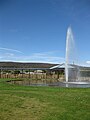 Water feature - geograph.org.uk - 1248387.jpg 480 × 640; 72 KB
-
 Arable land at Grendon Manor Farm - geograph.org.uk - 1516029.jpg 640 × 443; 131 KB
-
 Arable land near Lower Brockington Farm - geograph.org.uk - 1516037.jpg 640 × 480; 120 KB
-
 Arable land near Newbury Farm - geograph.org.uk - 1516054.jpg 640 × 480; 118 KB
-
 Bridge over the Humber Brook - geograph.org.uk - 1511328.jpg 640 × 480; 141 KB
-
 Bridleway to Bockleton - geograph.org.uk - 1512532.jpg 640 × 480; 96 KB


.jpg)


.jpg)
.jpg)


