Category:Arconciel, Ferme, La Souche
| Object location | | View all coordinates using: OpenStreetMap |
|---|
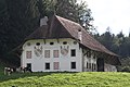
farmbuilding in Arconciel in the canton of Fribourg, Switzerland  | |||||
| Upload media | |||||
| Instance of | |||||
|---|---|---|---|---|---|
| Part of | |||||
| Location | Arconciel, Bois-d’Amont, Sarine District, Canton of Fribourg, Switzerland | ||||
| Located in or next to body of water | |||||
| Street address |
| ||||
| Heritage designation | |||||
| Inception |
| ||||
 | |||||
Media in category "Arconciel, Ferme, La Souche"
The following 2 files are in this category, out of 2 total.
-
 Arconciel Ferme.jpg 5,202 × 3,465; 10.32 MB
-
 Farm La Souche Arconciel Sep 2010.jpg 4,752 × 3,168; 5.13 MB
