Category:Ardtole
English: Ardtole is a townland of 472 acres in the Electoral Division of Ardglass, in Civil Parish of Ardglass, in the Barony of Lecale Lower, in the County of Down
human settlement in Northern Ireland | |||||
| Upload media | |||||
| Instance of | |||||
|---|---|---|---|---|---|
| Location |
| ||||
| |||||
Media in category "Ardtole"
The following 7 files are in this category, out of 7 total.
-
 A farmhouse at Ardtole - geograph.org.uk - 1522005.jpg 640 × 377; 72 KB
-
 Cropland at Ardtole - geograph.org.uk - 1522012.jpg 640 × 258; 33 KB
-
-
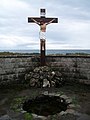
 St Patrick's Well, Ardtole - geograph.org.uk - 1535138.jpg 640 × 389; 33 KB
-

-

-
 The new Ardglass GAA Ground at Ardtole - geograph.org.uk - 2615749.jpg 1,024 × 768; 180 KB


