Category:Artilleriewerk Galenhütten
| Object location | | View all coordinates using: OpenStreetMap |
|---|
military fortifications in Oberwald in the canton of Valais, Switzerland  | |||||
| Upload media | |||||
| Instance of | |||||
|---|---|---|---|---|---|
| Part of | |||||
| Location | Oberwald, Obergoms, Goms District, Valais, Switzerland | ||||
| Heritage designation | |||||
 | |||||
|
This is a category about a cultural property of regional significance in Switzerland with KGS number 6914
|
Deutsch: A8605 Artilleriewerk Galenhütten
Fort Galenhütten / A8605 Artilleriewerk Galenhütten (1893 -
- 2 × 12 cm Kanonen / 2 canons de casemate de 12 cm
- 1 x 12 cm Panzerhaubitze / 1 obusier cuirassé de 12 cm
- 4 x 8,4 cm-Kanonen / 4 canons de caponnière de 8,4cm
Media in category "Artilleriewerk Galenhütten"
The following 17 files are in this category, out of 17 total.
-
 Artilleriewerk Galenhütten.jpg 1,422 × 830; 199 KB
-
 Belvedere Galenhütten Dia 348-05109.jpg 4,608 × 3,456; 4.41 MB
-
 Furkapass Galenhütten 02.JPG 2,816 × 2,112; 2.17 MB
-
 Furkapass Galenhütten.JPG 2,816 × 2,112; 1.06 MB
-
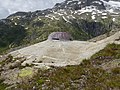
 Galenhüten, Ansicht von Osten.jpg 4,000 × 3,000; 4.64 MB
-
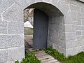
 Galenhüten, Eingang zu Küche und Zisterne.jpg 3,000 × 4,000; 4.92 MB
-
 Galenhüten, gepanzerte Beobachterkuppel.jpg 4,000 × 3,000; 4.91 MB
-
 Galenhüten, Kaponniere Nord.jpg 4,000 × 3,000; 4.73 MB
-
 Galenhüten, Kaponniere Süd.jpg 4,000 × 3,000; 4.66 MB
-
 Galenhüten, offener Innenhof.jpg 4,000 × 3,000; 4.49 MB
-
 Galenhüten,Ansicht von Westen.jpg 4,000 × 3,000; 4.94 MB
-
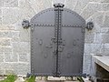 Galenhütten, Eingangstor.jpg 4,000 × 3,000; 4.5 MB
-
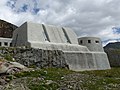
 Galenhütten, Frontalansicht.jpg 4,000 × 3,000; 4.98 MB
-
 Galenhütten, Graben.jpg 4,000 × 3,000; 4.54 MB
-
 Galenhütten, Mauer.jpg 4,000 × 3,000; 4.67 MB
-
 Galenhütten, verschlossener Unterstand.jpg 4,000 × 3,000; 5.08 MB
-
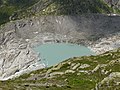 Rhonegletschersee von Galenhütten aus.jpg 4,000 × 3,000; 4.66 MB


