Category:Aubrey Valley

valley in Arizona, United States of America | |||||
| Upload media | |||||
| Instance of | |||||
|---|---|---|---|---|---|
| Location | Arizona | ||||
| Length |
| ||||
 | |||||
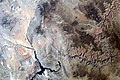
English: Aubrey Valley — a scenic desert valley in southwestern Coconino County, and into northwestern Yavapai County, in the High Plateaus section of Arizona.
- Arizona State Route 66 (Historic U.S. Route 66) passes through the valley.
- The Aubrey Cliffs form the east and northeast valley border, and are part of the escarpment at the southwest perimeter of the Coconino Plateau.
Media in category "Aubrey Valley"
The following 5 files are in this category, out of 5 total.
-
 Map of the Grand Canyon National Park 1926.jpg 4,696 × 2,668; 2.43 MB
-
 AZ State Route 66.jpg 936 × 556; 88 KB
-
 Grand Canyon area of Arizona by Sally Ride EarthKAM.jpg 4,312 × 2,868; 6.62 MB
-
 SB Point, Tuckup Canyon, Tuckup Point, Whitmore Wash, Toroweap Valley, and Shivwits Plateau.png 1,125 × 2,001; 11.68 MB
-


,_Diamond_Canyon,_(West_Colorado_R.),_GC,_west,_and_(South_Rim_region),_Aubrey_Cliffs,_and_Canyon.png)