Category:Auburn State Recreation Area
state recreation area in California, USA  | |||||
| Upload media | |||||
| Instance of |
| ||||
|---|---|---|---|---|---|
| Location |
| ||||
| official website | |||||
 | |||||
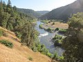
Auburn State Recreation Area extends 20 miles from about Auburn to Colfax south of Interstate 80 in California, USA. It surrounds the North and Middle Forks of the American River in Placer and El Dorado Counties.
Media in category "Auburn State Recreation Area"
The following 6 files are in this category, out of 6 total.
-
 AubrunStateRecreationArea.JPG 2,576 × 1,932; 1.58 MB
-
 Auburn State Recreation Area 2.jpg 2,048 × 1,536; 769 KB
-
 Auburn State Recreation Area.jpg 2,048 × 1,536; 1.32 MB
-
 Middle Fork American River at Sliger Mine.JPG 3,648 × 2,736; 3.38 MB
-
 Middle Fork American River near Browns Bar.JPG 3,648 × 2,736; 3.07 MB
-
 Middle Fork American River Near Confluence.JPG 3,648 × 2,736; 2.4 MB


