Category:Auob River
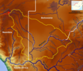
river in Namibia and South Africa  | |||||
| Upload media | |||||
| Instance of | |||||
|---|---|---|---|---|---|
| Location | Hardap Region, Namibia | ||||
| Length |
| ||||
| Elevation above sea level |
| ||||
| Mouth of the watercourse | |||||
| Drainage basin | |||||
 | |||||
Subcategories
This category has the following 2 subcategories, out of 2 total.
A
- Auchterlonie waterhole (4 F)
Media in category "Auob River"
The following 11 files are in this category, out of 11 total.
-
 Aloe hereroensis Auob C15.JPG 1,201 × 1,200; 418 KB
-
 Auchterlonie Museum (31180749377).jpg 5,472 × 2,657; 11.77 MB
-
 Auob at Gochas.jpg 5,472 × 3,648; 9.11 MB
-
 Auob matamata2.jpg 1,024 × 682; 294 KB
-
 Auob Valley.jpg 1,024 × 682; 266 KB
-
 Kreuzung der Hauptstraßen C18 und C15 bei Gochas, Namibia (2017) mit Strassenbezeichnung.jpg 4,928 × 3,264; 6.94 MB
-
 Kreuzung der Hauptstraßen C18 und C15 bei Gochas, Namibia (2017).jpg 4,928 × 3,264; 7.05 MB
-
 Matamata Camp Gate ... (50111640172).jpg 5,222 × 3,103; 10.76 MB
-
 Matamata Waterhole illuminated at night ... (50111397873).jpg 5,472 × 3,140; 9.19 MB
-
 Molopo Basin OSM.png 7,183 × 6,202; 38.72 MB
-
 Red Dune ... (33235101828).jpg 5,472 × 3,243; 5.24 MB

.jpg)


_mit_Strassenbezeichnung.jpg)
.jpg)
.jpg)
.jpg)

.jpg)